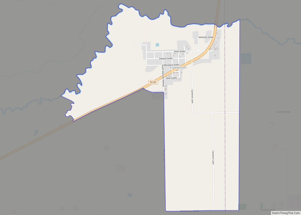
Fowlerton is a census-designated place (CDP) in La Salle County, Texas, United States. Its population was 55 at the 2010 census.
| Name: | Fowlerton CDP |
|---|---|
| LSAD Code: | 57 |
| LSAD Description: | CDP (suffix) |
| State: | Texas |
| County: | La Salle County |
| Elevation: | 318 ft (97 m) |
| Total Area: | 2.18 sq mi (5.64 km²) |
| Land Area: | 2.17 sq mi (5.62 km²) |
| Water Area: | 0.004 sq mi (0.01 km²) |
| Total Population: | 73 |
| Population Density: | 25/sq mi (9.8/km²) |
| ZIP code: | 78021 |
| Area code: | 830 |
| FIPS code: | 4827144 |
| GNISfeature ID: | 2408251 |
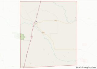
Online Interactive Map
Click on ![]() to view map in "full screen" mode.
to view map in "full screen" mode.
Fowlerton location map. Where is Fowlerton CDP?


History
Fowlerton is named for two brothers who settled the community about 1910. By 1914, Fowlerton peaked in population at around 1,000, and had telephone service. Farmers faced droughts and low prices. The Fowler brothers had described themselves as “colonizers” and widely advertised the town. They soon faced lawsuits from disgruntled settlers. By 1925, the population had declined to about 600, and never recovered. The San Antonio, Uvalde and Gulf Railroad, now part of Union Pacific, brought only temporary prosperity to Fowlerton.
Fowlerton Road Map

Fowlerton city Satellite Map

Geography
Fowlerton is located in northeastern La Salle County at 28°27′53″N 98°48′42″W / 28.46472°N 98.81167°W / 28.46472; -98.81167 (28.464840, -98.811642). It is bordered to the east by McMullen County. Texas State Highway 97 passes through the community, leading north 29 miles (47 km) to Charlotte and west 27 miles (43 km) to Cotulla. Texas State Highway 72 leaves Highway 97 2 miles (3 km) north of Fowlerton and leads east 39 miles (63 km) to Three Rivers. San Antonio is 75 miles (121 km) north of Fowlerton, Corpus Christi is 114 miles (183 km) to the southeast, and Laredo is 100 miles (160 km) to the southwest.
According to the U.S. Census Bureau, the Fowlerton CDP has a total area of 2.2 square miles (5.6 km), of which 0.004 square miles (0.01 km), or 0.22%, are water. The Frio River runs along the northern edge of the community, leading east to the Nueces River at Three Rivers.
See also
Map of Texas State and its subdivision:- Anderson
- Andrews
- Angelina
- Aransas
- Archer
- Armstrong
- Atascosa
- Austin
- Bailey
- Bandera
- Bastrop
- Baylor
- Bee
- Bell
- Bexar
- Blanco
- Borden
- Bosque
- Bowie
- Brazoria
- Brazos
- Brewster
- Briscoe
- Brooks
- Brown
- Burleson
- Burnet
- Caldwell
- Calhoun
- Callahan
- Cameron
- Camp
- Carson
- Cass
- Castro
- Chambers
- Cherokee
- Childress
- Clay
- Cochran
- Coke
- Coleman
- Collin
- Collingsworth
- Colorado
- Comal
- Comanche
- Concho
- Cooke
- Coryell
- Cottle
- Crane
- Crockett
- Crosby
- Culberson
- Dallam
- Dallas
- Dawson
- Deaf Smith
- Delta
- Denton
- Dewitt
- Dickens
- Dimmit
- Donley
- Duval
- Eastland
- Ector
- Edwards
- El Paso
- Ellis
- Erath
- Falls
- Fannin
- Fayette
- Fisher
- Floyd
- Foard
- Fort Bend
- Franklin
- Freestone
- Frio
- Gaines
- Galveston
- Garza
- Gillespie
- Glasscock
- Goliad
- Gonzales
- Gray
- Grayson
- Gregg
- Grimes
- Guadalupe
- Hale
- Hall
- Hamilton
- Hansford
- Hardeman
- Hardin
- Harris
- Harrison
- Hartley
- Haskell
- Hays
- Hemphill
- Henderson
- Hidalgo
- Hill
- Hockley
- Hood
- Hopkins
- Houston
- Howard
- Hudspeth
- Hunt
- Hutchinson
- Irion
- Jack
- Jackson
- Jasper
- Jeff Davis
- Jefferson
- Jim Hogg
- Jim Wells
- Johnson
- Jones
- Karnes
- Kaufman
- Kendall
- Kenedy
- Kent
- Kerr
- Kimble
- King
- Kinney
- Kleberg
- Knox
- La Salle
- Lamar
- Lamb
- Lampasas
- Lavaca
- Lee
- Leon
- Liberty
- Limestone
- Lipscomb
- Live Oak
- Llano
- Loving
- Lubbock
- Lynn
- Madison
- Marion
- Martin
- Mason
- Matagorda
- Maverick
- McCulloch
- McLennan
- McMullen
- Medina
- Menard
- Midland
- Milam
- Mills
- Mitchell
- Montague
- Montgomery
- Moore
- Morris
- Motley
- Nacogdoches
- Navarro
- Newton
- Nolan
- Nueces
- Ochiltree
- Oldham
- Orange
- Palo Pinto
- Panola
- Parker
- Parmer
- Pecos
- Polk
- Potter
- Presidio
- Rains
- Randall
- Reagan
- Real
- Red River
- Reeves
- Refugio
- Roberts
- Robertson
- Rockwall
- Runnels
- Rusk
- Sabine
- San Augustine
- San Jacinto
- San Patricio
- San Saba
- Schleicher
- Scurry
- Shackelford
- Shelby
- Sherman
- Smith
- Somervell
- Starr
- Stephens
- Sterling
- Stonewall
- Sutton
- Swisher
- Tarrant
- Taylor
- Terrell
- Terry
- Throckmorton
- Titus
- Tom Green
- Travis
- Trinity
- Tyler
- Upshur
- Upton
- Uvalde
- Val Verde
- Van Zandt
- Victoria
- Walker
- Waller
- Ward
- Washington
- Webb
- Wharton
- Wheeler
- Wichita
- Wilbarger
- Willacy
- Williamson
- Wilson
- Winkler
- Wise
- Wood
- Yoakum
- Young
- Zapata
- Zavala
- Alabama
- Alaska
- Arizona
- Arkansas
- California
- Colorado
- Connecticut
- Delaware
- District of Columbia
- Florida
- Georgia
- Hawaii
- Idaho
- Illinois
- Indiana
- Iowa
- Kansas
- Kentucky
- Louisiana
- Maine
- Maryland
- Massachusetts
- Michigan
- Minnesota
- Mississippi
- Missouri
- Montana
- Nebraska
- Nevada
- New Hampshire
- New Jersey
- New Mexico
- New York
- North Carolina
- North Dakota
- Ohio
- Oklahoma
- Oregon
- Pennsylvania
- Rhode Island
- South Carolina
- South Dakota
- Tennessee
- Texas
- Utah
- Vermont
- Virginia
- Washington
- West Virginia
- Wisconsin
- Wyoming