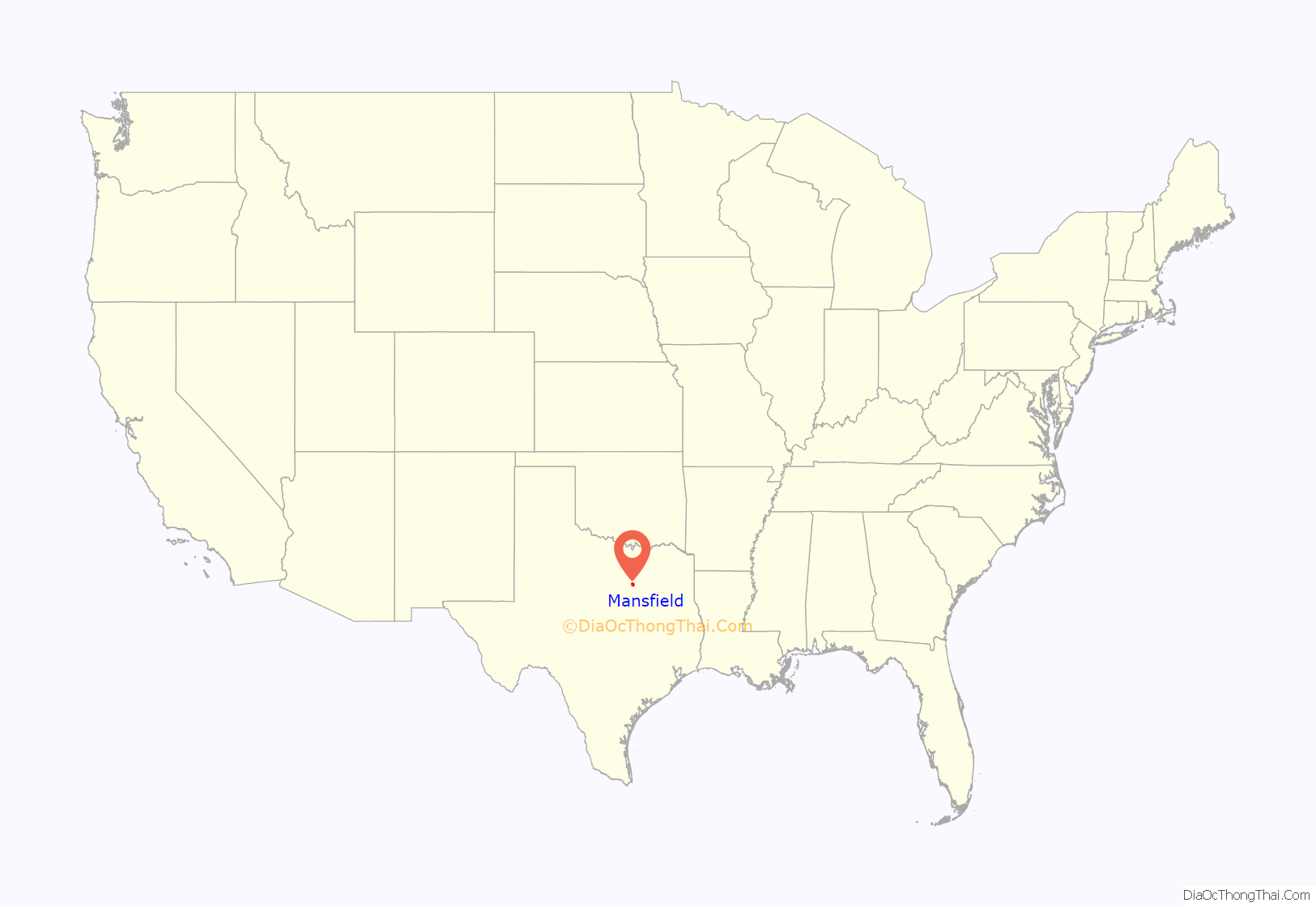
Mansfield is a suburban city in the U.S. state of Texas, and is part of the Dallas–Fort Worth metroplex area. The city is located mostly in Tarrant County, with small parts in Ellis and Johnson counties. Its location is approximately 30 miles from Dallas and 20 miles from Fort Worth, and is adjacent to Arlington. As of the 2010 census, the population was 56,368, up from 28,031 in 2000. The estimated population in 2020 is 73,550.
| Name: | Mansfield city |
|---|---|
| LSAD Code: | 25 |
| LSAD Description: | city (suffix) |
| State: | Texas |
| County: | Ellis County, Johnson County, Tarrant County |
| Elevation: | 604 ft (184 m) |
| Land Area: | 36.62 sq mi (94.85 km²) |
| Water Area: | 0.04 sq mi (0.11 km²) |
| Population Density: | 1,977.47/sq mi (763.50/km²) |
| ZIP code: | 76063 |
| Area code: | 817, 682 |
| FIPS code: | 4846452 |
| GNISfeature ID: | 1340898 |
| Website: | mansfieldtexas.gov |
Online Interactive Map
Click on ![]() to view map in "full screen" mode.
to view map in "full screen" mode.
Mansfield location map. Where is Mansfield city?
History
The first wave of European settlers arrived in the rolling Cross Timbers country of north central Texas in the 1840s. Primarily of Scotch-Irish origins, these pioneer farmers came for the most part from southern states, following the frontier as it shifted west of the Mississippi. They entered an area where Native Americans had been living for thousands of years. The Comanche posed a serious threat to the settlers, and in 1849, the U.S. Army established Fort Worth to protect the farms along the sparsely populated frontier.
The area southeast of the fort (and of the Trinity River) was well protected and presumably fairly well settled by the early 1850s. In one well-documented case, eight related families migrated to the area in 1853 from Illinois. Three of the four Gibson brothers in this group established homesteads about 4 miles (6 km) northwest of present-day Mansfield. This settlement, which became known as the Gibson Community, included a school and a church building by 1860.
When Ralph Sandiford Mann and Julian Feild arrived around 1856 and built a grist mill at the crossroads that was to become the center of Mansfield, the beginnings of the community probably existed in the oak groves bordering Walnut Creek (originally called Cedar Bluff Creek). The Walnut Creek Congregation of the Cumberland Presbyterian Church had organized itself in 1854. Members met in each other’s homes, so it is suspected that there was a cluster of houses in the area.
In 1856, Julian Feild purchased 540 acres (2.2 km) in the Mansfield area. Man and Feild completed their three-story brick grist mill sometime between 1856 and 1859. The mill, which produced flour and meal, was the first built in North Texas to utilize steam power and enjoyed patronage as far south as San Antonio and as far north as Oklahoma. The location of the mill in southeastern Tarrant County perhaps reflects the advanced state of wheat cultivation in the area and the ready availability of wood to feed the mill’s steam boilers.
Feild opened a general merchandise store at the same time as the mill, located across Broad Street. He built a log house for his family, which also served as an inn for travelers and customers. By 1860, the nucleus of the future city existed. The first post office was established that year, with Julian Feild as postmaster.
During the American Civil War, the Man and Feild Mill supplied meal and flour to the Confederate States Army, hauling it to Shreveport, Louisiana, and Jefferson City, Missouri. As was common practice, the owners tithed ten percent of the mill’s production to the Confederacy. The small community around the mill was unique in Tarrant County in that it prospered throughout the Civil War. “Feild’s Freighters”, assembled in ox-drawn wagon trains, went as far as Fort Sill, Oklahoma, where a part of the Indian Wars raged in the southern plains in the late 1860s and 1870s.
The prospering community which had grown up around the Man and Feild mill took on the name of “Mansfeild”, a combination of the names of the founders. Repeated misspellings over the years resulted in the acceptance of the conventional spelling of “Mansfield.” The town incorporated in 1909, continuing to be a hub for the surrounding farmland.
In 1956, a federal court ordered the Mansfield Independent School District to desegregate; the first such order in Texas. Protests by 300 whites in front of Mansfield High School, to prevent three black students from enrolling, touched off one of the longest-running desegregation battles of the Civil Rights Movement. Mansfield’s school quietly desegregated in 1965 as it faced a lack of federal funds.
Mansfield Road Map
Mansfield city Satellite Map
Geography
According to the United States Census Bureau, the city has a total area of 36.4 square miles (94.3 km), of which 36.4 square miles (94.2 km) is land and 0.04 square miles (0.1 km), or 0.12%, is water.
See also
Map of Texas State and its subdivision:- Anderson
- Andrews
- Angelina
- Aransas
- Archer
- Armstrong
- Atascosa
- Austin
- Bailey
- Bandera
- Bastrop
- Baylor
- Bee
- Bell
- Bexar
- Blanco
- Borden
- Bosque
- Bowie
- Brazoria
- Brazos
- Brewster
- Briscoe
- Brooks
- Brown
- Burleson
- Burnet
- Caldwell
- Calhoun
- Callahan
- Cameron
- Camp
- Carson
- Cass
- Castro
- Chambers
- Cherokee
- Childress
- Clay
- Cochran
- Coke
- Coleman
- Collin
- Collingsworth
- Colorado
- Comal
- Comanche
- Concho
- Cooke
- Coryell
- Cottle
- Crane
- Crockett
- Crosby
- Culberson
- Dallam
- Dallas
- Dawson
- Deaf Smith
- Delta
- Denton
- Dewitt
- Dickens
- Dimmit
- Donley
- Duval
- Eastland
- Ector
- Edwards
- El Paso
- Ellis
- Erath
- Falls
- Fannin
- Fayette
- Fisher
- Floyd
- Foard
- Fort Bend
- Franklin
- Freestone
- Frio
- Gaines
- Galveston
- Garza
- Gillespie
- Glasscock
- Goliad
- Gonzales
- Gray
- Grayson
- Gregg
- Grimes
- Guadalupe
- Hale
- Hall
- Hamilton
- Hansford
- Hardeman
- Hardin
- Harris
- Harrison
- Hartley
- Haskell
- Hays
- Hemphill
- Henderson
- Hidalgo
- Hill
- Hockley
- Hood
- Hopkins
- Houston
- Howard
- Hudspeth
- Hunt
- Hutchinson
- Irion
- Jack
- Jackson
- Jasper
- Jeff Davis
- Jefferson
- Jim Hogg
- Jim Wells
- Johnson
- Jones
- Karnes
- Kaufman
- Kendall
- Kenedy
- Kent
- Kerr
- Kimble
- King
- Kinney
- Kleberg
- Knox
- La Salle
- Lamar
- Lamb
- Lampasas
- Lavaca
- Lee
- Leon
- Liberty
- Limestone
- Lipscomb
- Live Oak
- Llano
- Loving
- Lubbock
- Lynn
- Madison
- Marion
- Martin
- Mason
- Matagorda
- Maverick
- McCulloch
- McLennan
- McMullen
- Medina
- Menard
- Midland
- Milam
- Mills
- Mitchell
- Montague
- Montgomery
- Moore
- Morris
- Motley
- Nacogdoches
- Navarro
- Newton
- Nolan
- Nueces
- Ochiltree
- Oldham
- Orange
- Palo Pinto
- Panola
- Parker
- Parmer
- Pecos
- Polk
- Potter
- Presidio
- Rains
- Randall
- Reagan
- Real
- Red River
- Reeves
- Refugio
- Roberts
- Robertson
- Rockwall
- Runnels
- Rusk
- Sabine
- San Augustine
- San Jacinto
- San Patricio
- San Saba
- Schleicher
- Scurry
- Shackelford
- Shelby
- Sherman
- Smith
- Somervell
- Starr
- Stephens
- Sterling
- Stonewall
- Sutton
- Swisher
- Tarrant
- Taylor
- Terrell
- Terry
- Throckmorton
- Titus
- Tom Green
- Travis
- Trinity
- Tyler
- Upshur
- Upton
- Uvalde
- Val Verde
- Van Zandt
- Victoria
- Walker
- Waller
- Ward
- Washington
- Webb
- Wharton
- Wheeler
- Wichita
- Wilbarger
- Willacy
- Williamson
- Wilson
- Winkler
- Wise
- Wood
- Yoakum
- Young
- Zapata
- Zavala
- Alabama
- Alaska
- Arizona
- Arkansas
- California
- Colorado
- Connecticut
- Delaware
- District of Columbia
- Florida
- Georgia
- Hawaii
- Idaho
- Illinois
- Indiana
- Iowa
- Kansas
- Kentucky
- Louisiana
- Maine
- Maryland
- Massachusetts
- Michigan
- Minnesota
- Mississippi
- Missouri
- Montana
- Nebraska
- Nevada
- New Hampshire
- New Jersey
- New Mexico
- New York
- North Carolina
- North Dakota
- Ohio
- Oklahoma
- Oregon
- Pennsylvania
- Rhode Island
- South Carolina
- South Dakota
- Tennessee
- Texas
- Utah
- Vermont
- Virginia
- Washington
- West Virginia
- Wisconsin
- Wyoming
