North Richland Hills, commonly known as NRH, is a city inside Tarrant County, Texas, United States, and a mid-to-high end suburb of Fort Worth. The population was 69,917 at the 2020 census, making it the third largest city in Tarrant County. In 2006, North Richland Hills was selected as one of the “Top 100 Best Places to live in America” according to Money magazine, and in 2016, the Dallas Morning News ranked North Richland Hills #9 on its list of best Dallas–Fort Worth neighborhoods. Major streets and highways include: FM 1938 (Davis Boulevard), Mid Cities Boulevard, Bedford-Euless Road, Interstate Highway 820, North Tarrant Parkway, FM 3029 (Precinct Line Road), and TX SH 26. It is home to the Birdville Independent School District, and the northern portion is served by Keller ISD.
NRH notably houses the headquarters of HealthMarkets. North Richland Hills features popular businesses and locations, including the NRH20 Water Park, Medical City North Hills, and its own state-of-the-art public library. Additionally, NRH is surrounded by numerous communities, such as Haltom City, Keller, Hurst, and Southlake. It also housed the now-demolished North Hills Mall, which ceased operations in 2004. As of 2016, that site is now the new location of the North Richland Hills City Hall. In 2012, North Richland Hills was ranked at #44 as one of the Best Dallas Suburbs according to D Magazine.
| Name: | North Richland Hills city |
|---|---|
| LSAD Code: | 25 |
| LSAD Description: | city (suffix) |
| State: | Texas |
| County: | Tarrant County |
| Founded: | 1849 |
| Incorporated: | 1953 |
| Elevation: | 604 ft (184 m) |
| Total Area: | 18.21 sq mi (47.16 km²) |
| Land Area: | 18.43 sq mi (47.74 km²) |
| Water Area: | 0.04 sq mi (0.11 km²) 0.16% |
| Total Population: | 69,917 |
| Population Density: | 576.06/sq mi (1,492/km²) |
| ZIP code: | 76053-54, 76117, 76184, 76180, 76182 |
| Area code: | 817 |
| FIPS code: | 4852356 |
| GNISfeature ID: | 1375190 |
| Website: | nrhtx.com |
Online Interactive Map
Click on ![]() to view map in "full screen" mode.
to view map in "full screen" mode.
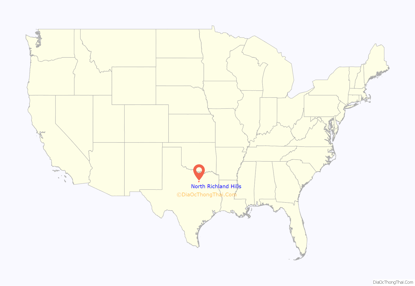
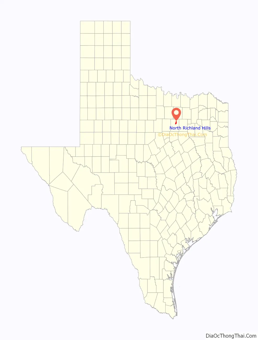
North Richland Hills location map. Where is North Richland Hills city?
History
The community began when W.S. Peters agreed to bring 600 families into the area within a three-year period as part of a land grant. Families began arriving in the summer of 1848. In 1849, Tarrant County was established and named for General Edward H. Tarrant. The community of Birdville (adjacent to what is now the southwest boundary of North Richland Hills) was named the first county seat. The area remained a rural farming and ranching community for more than 100 years.
In 1952, Clarence Jones began to subdivide his 268-acre (1.08 km) dairy farm into a suburban addition in the area that is now Cummings Drive. In 1953, the North Richland Hills Civic League sought to have the area annexed to Richland Hills, then voted to form their own city when annexation was denied. An election was held, and the 268 acres (1.08 km) of the Jones Farm, with a population of 500, became officially incorporated as the City of North Richland Hills.
The first section of streets in North Richland Hills was named for the local families. The second section, which was added in 1954, was named for automobiles. There were 188 homes in the first part of the subdivision, which was restricted to brick and masonry construction.
By 1957, the North Richland Hills’ boundary was within 2 miles (3 km) of Smithfield, and by 1960, Smithfield had been annexed into North Richland Hills. In 1960, the population of North Richland Hills was beginning to rise at 8,662 residents, with that number more than doubling to 16,514 by 1970. The city’s population continued to grow at a rapid pace, with the 1980 census at 30,592, and the 1990 census reflecting 45,895. In 2000, the population was at 55,635, and rise to 63,343 at the 2010 census. In 2020, the population was at 69,917.
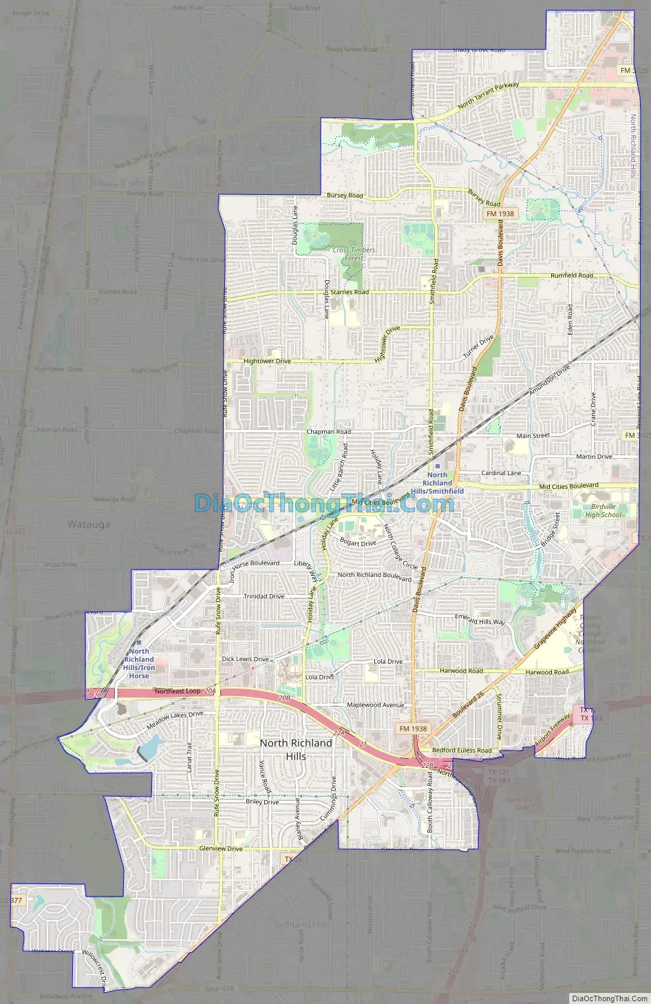
North Richland Hills Road Map
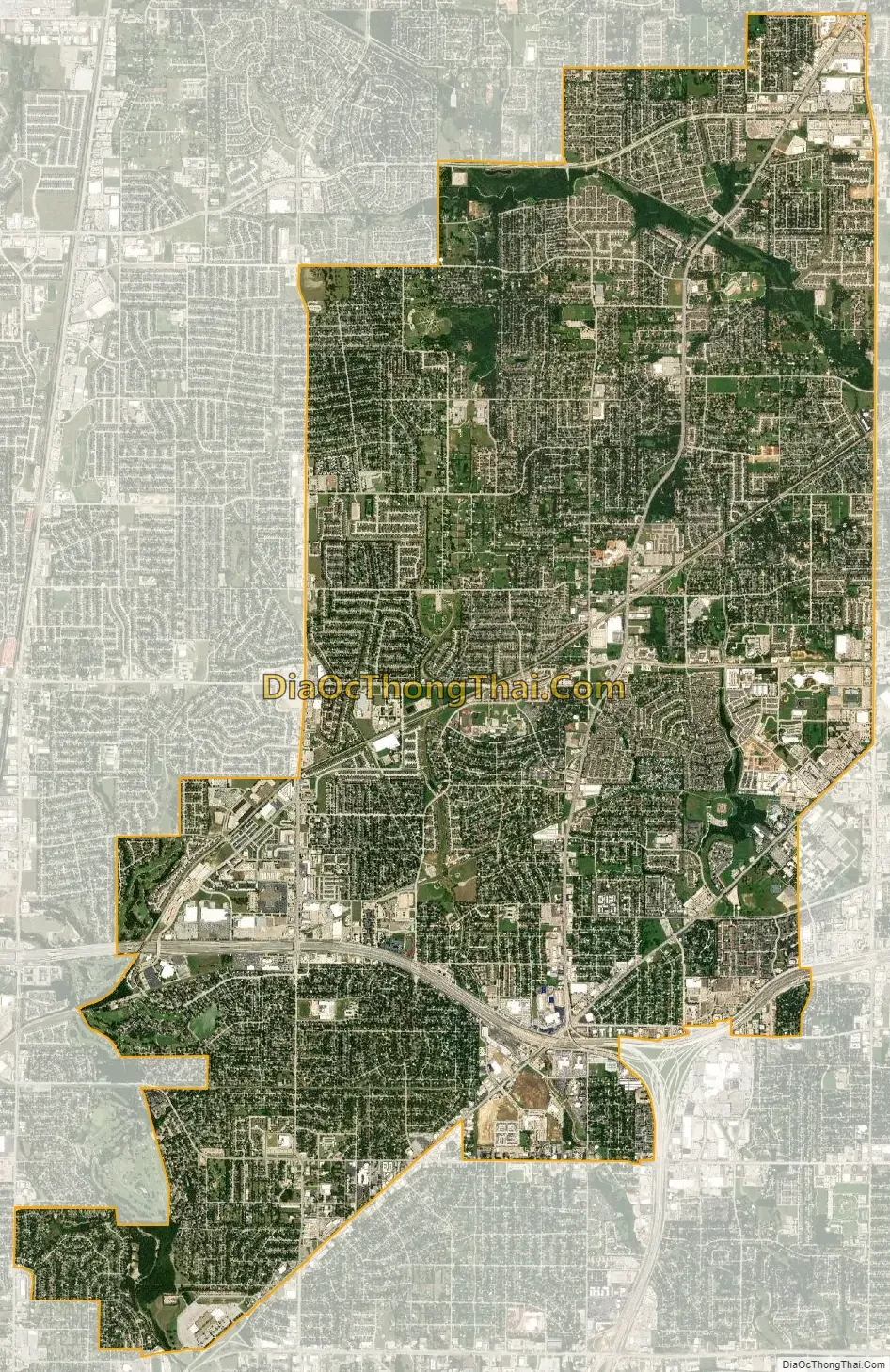
North Richland Hills city Satellite Map
Geography
North Richland Hills is located at 32°51′20″N 97°13′5″W / 32.85556°N 97.21806°W / 32.85556; -97.21806 (32.855666, –97.218184).
According to the United States Census Bureau, the city has a total area of 18.2 square miles (47.2 km), of which 18.2 square miles (47.1 km) is land, and 0.04 square miles (0.1 km), or 0.24%, is water.
See also
Map of Texas State and its subdivision:- Anderson
- Andrews
- Angelina
- Aransas
- Archer
- Armstrong
- Atascosa
- Austin
- Bailey
- Bandera
- Bastrop
- Baylor
- Bee
- Bell
- Bexar
- Blanco
- Borden
- Bosque
- Bowie
- Brazoria
- Brazos
- Brewster
- Briscoe
- Brooks
- Brown
- Burleson
- Burnet
- Caldwell
- Calhoun
- Callahan
- Cameron
- Camp
- Carson
- Cass
- Castro
- Chambers
- Cherokee
- Childress
- Clay
- Cochran
- Coke
- Coleman
- Collin
- Collingsworth
- Colorado
- Comal
- Comanche
- Concho
- Cooke
- Coryell
- Cottle
- Crane
- Crockett
- Crosby
- Culberson
- Dallam
- Dallas
- Dawson
- Deaf Smith
- Delta
- Denton
- Dewitt
- Dickens
- Dimmit
- Donley
- Duval
- Eastland
- Ector
- Edwards
- El Paso
- Ellis
- Erath
- Falls
- Fannin
- Fayette
- Fisher
- Floyd
- Foard
- Fort Bend
- Franklin
- Freestone
- Frio
- Gaines
- Galveston
- Garza
- Gillespie
- Glasscock
- Goliad
- Gonzales
- Gray
- Grayson
- Gregg
- Grimes
- Guadalupe
- Hale
- Hall
- Hamilton
- Hansford
- Hardeman
- Hardin
- Harris
- Harrison
- Hartley
- Haskell
- Hays
- Hemphill
- Henderson
- Hidalgo
- Hill
- Hockley
- Hood
- Hopkins
- Houston
- Howard
- Hudspeth
- Hunt
- Hutchinson
- Irion
- Jack
- Jackson
- Jasper
- Jeff Davis
- Jefferson
- Jim Hogg
- Jim Wells
- Johnson
- Jones
- Karnes
- Kaufman
- Kendall
- Kenedy
- Kent
- Kerr
- Kimble
- King
- Kinney
- Kleberg
- Knox
- La Salle
- Lamar
- Lamb
- Lampasas
- Lavaca
- Lee
- Leon
- Liberty
- Limestone
- Lipscomb
- Live Oak
- Llano
- Loving
- Lubbock
- Lynn
- Madison
- Marion
- Martin
- Mason
- Matagorda
- Maverick
- McCulloch
- McLennan
- McMullen
- Medina
- Menard
- Midland
- Milam
- Mills
- Mitchell
- Montague
- Montgomery
- Moore
- Morris
- Motley
- Nacogdoches
- Navarro
- Newton
- Nolan
- Nueces
- Ochiltree
- Oldham
- Orange
- Palo Pinto
- Panola
- Parker
- Parmer
- Pecos
- Polk
- Potter
- Presidio
- Rains
- Randall
- Reagan
- Real
- Red River
- Reeves
- Refugio
- Roberts
- Robertson
- Rockwall
- Runnels
- Rusk
- Sabine
- San Augustine
- San Jacinto
- San Patricio
- San Saba
- Schleicher
- Scurry
- Shackelford
- Shelby
- Sherman
- Smith
- Somervell
- Starr
- Stephens
- Sterling
- Stonewall
- Sutton
- Swisher
- Tarrant
- Taylor
- Terrell
- Terry
- Throckmorton
- Titus
- Tom Green
- Travis
- Trinity
- Tyler
- Upshur
- Upton
- Uvalde
- Val Verde
- Van Zandt
- Victoria
- Walker
- Waller
- Ward
- Washington
- Webb
- Wharton
- Wheeler
- Wichita
- Wilbarger
- Willacy
- Williamson
- Wilson
- Winkler
- Wise
- Wood
- Yoakum
- Young
- Zapata
- Zavala
- Alabama
- Alaska
- Arizona
- Arkansas
- California
- Colorado
- Connecticut
- Delaware
- District of Columbia
- Florida
- Georgia
- Hawaii
- Idaho
- Illinois
- Indiana
- Iowa
- Kansas
- Kentucky
- Louisiana
- Maine
- Maryland
- Massachusetts
- Michigan
- Minnesota
- Mississippi
- Missouri
- Montana
- Nebraska
- Nevada
- New Hampshire
- New Jersey
- New Mexico
- New York
- North Carolina
- North Dakota
- Ohio
- Oklahoma
- Oregon
- Pennsylvania
- Rhode Island
- South Carolina
- South Dakota
- Tennessee
- Texas
- Utah
- Vermont
- Virginia
- Washington
- West Virginia
- Wisconsin
- Wyoming