Farmers Branch, officially the City of Farmers Branch, is a city in Dallas County, Texas, United States. It is an inner-ring suburb of Dallas and is part of the Dallas–Fort Worth metroplex. Its population was 35,991 at the 2020 census.
Known as a “City in a Park” for its 28 parks in only 12 square miles, Farmers Branch is a small community in close proximity to Dallas, and has a business community that accounts for 80% of the city’s tax base, allowing residents to have one of the lower city tax rates in Dallas County, while having dedicated city services and public safety.
| Name: | Farmers Branch city |
|---|---|
| LSAD Code: | 25 |
| LSAD Description: | city (suffix) |
| State: | Texas |
| County: | Dallas County |
| Incorporated: | February 23, 1946 |
| Elevation: | 463 ft (141 m) |
| Land Area: | 11.88 sq mi (30.77 km²) |
| Water Area: | 0.16 sq mi (0.41 km²) 0.8% |
| Population Density: | 4,053.36/sq mi (1,565.02/km²) |
| ZIP code: | 75234, 75244 |
| Area code: | 214, 469, 945, 972 |
| FIPS code: | 4825452 |
| GNISfeature ID: | 1335711 |
| Website: | farmersbranchtx.gov |
Online Interactive Map
Click on ![]() to view map in "full screen" mode.
to view map in "full screen" mode.
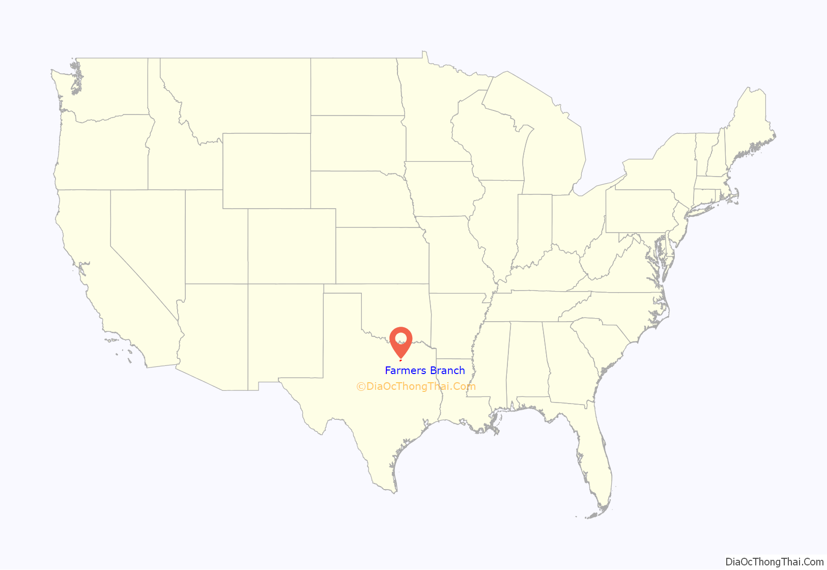
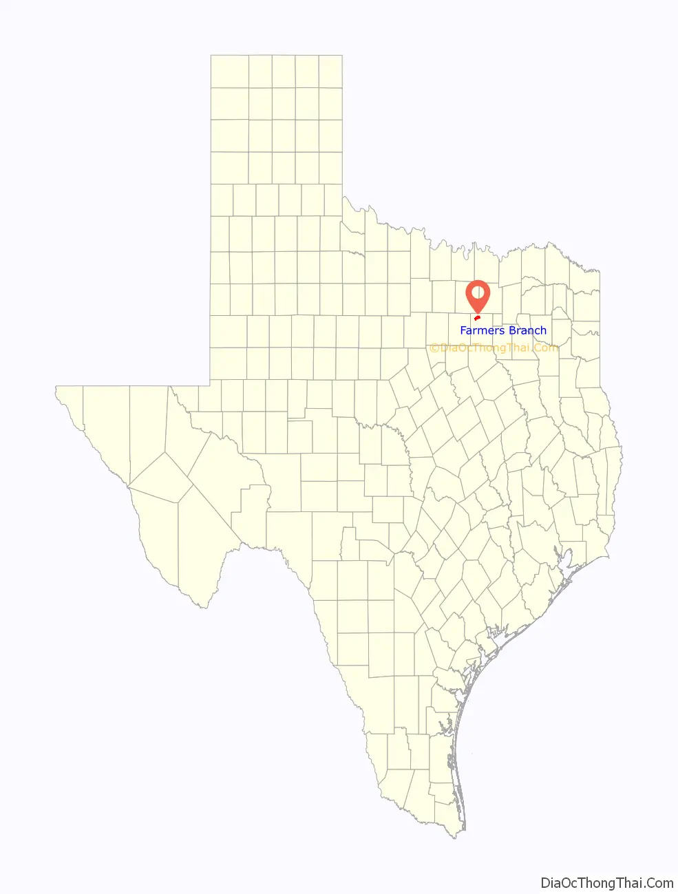
Farmers Branch location map. Where is Farmers Branch city?
History
The community was first settled in the early 1850s. In 1842, Thomas Keenan, Isaac B. Webb, and William Cochran received original land grants in the area. By 1843, a community called Mustang Branch had been established. Mr. Cochran later changed the name to Farmers Branch to reflect the area’s rich soil and farmland. Farmers Branch was the first location of the Texan Land and Emigration Company (or Peters Colony) in 1845. This made the community one of the best-known places in Dallas County during the 1840s because of its advertising throughout Europe and the United States. Baptist minister William Bowles opened a blacksmith shop and gristmill in 1845. On May 5, 1845, Isaac B. Webb donated land for Webb’s Chapel Methodist Church, the first formal place of worship in Dallas County. A school was established in the church one year later. Webb became the first postmaster at the Farmers Branch post office, which opened on January 5, 1848. It continued to function until its closure in 1866. The post office reopened in 1875. To assure that railroads would eventually pass through Farmers Branch, prominent early settler Samuel Gilbert and others sold right-of-way through their land in 1874. Around three to four years later, the Dallas and Wichita Railway completed a track from Dallas—through Farmers Branch—to Lewisville. It was absorbed by the Missouri–Kansas–Texas Railroad in 1881. The community had a population around 100 by 1890, with several businesses. The population had grown to 300 during the early 1900s. A brick school building was constructed in 1916. The number of people living in the community remained stable until after World War II.
Farmers Branch was incorporated as a city after an election was held on February 23, 1946. William F. (Bill) Dodson was elected as the city’s first mayor. The implementation of city services began immediately after incorporation. In the 1950 census, Farmers Branch had a population of 915. In 1956, a home-rule charter was approved that adopted a council-manager form of government. The rapid growth of the city during the 1950s was made apparent in the 1960 census, which recorded a total of 13,441 residents, a 1,369% increase over the 1950 figure. Most of the new residents commuted to nearby Dallas for employment. The population topped 27,000 by 1970. A variety of manufacturers producing items such as steel products, concrete, asphalt, cosmetics, and food products was operating in the city. The number of residents declined to 24,863 in 1980 and 24,250 in 1990. The falling population was offset, however, by the wide variety of businesses located in the city. Farmers Branch is home to a large number of corporations that have attained frontage along Interstate 635, the Dallas North Tollway, and Interstate 35E. Its Dallas North Tollway segment is part of the Platinum Corridor, and its land along Interstate 635 is an extension of the lengthy Irving Prairie office park. By 2000, the city’s population had grown to 27,508. In 2017, the community elected the city’s first millennial mayor, and by 2020 the city’s population had grown to 35,991.
Farmers Branch Road Map
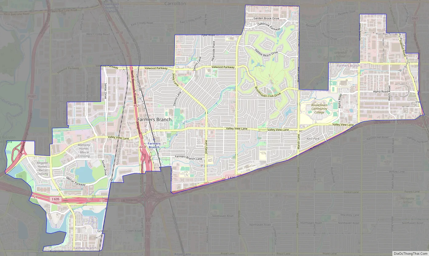
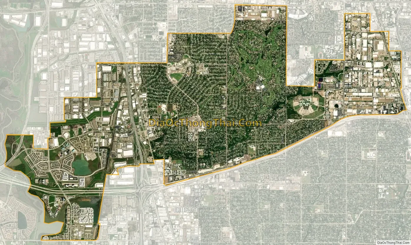
Farmers Branch city Satellite Map
Geography
According to the United States Census Bureau, the city has a total area of 11.79 sq mi (30.54 km) with only 0.08% (0.09 sq mi – 0.24 km2) covered by water.
See also
Map of Texas State and its subdivision:- Anderson
- Andrews
- Angelina
- Aransas
- Archer
- Armstrong
- Atascosa
- Austin
- Bailey
- Bandera
- Bastrop
- Baylor
- Bee
- Bell
- Bexar
- Blanco
- Borden
- Bosque
- Bowie
- Brazoria
- Brazos
- Brewster
- Briscoe
- Brooks
- Brown
- Burleson
- Burnet
- Caldwell
- Calhoun
- Callahan
- Cameron
- Camp
- Carson
- Cass
- Castro
- Chambers
- Cherokee
- Childress
- Clay
- Cochran
- Coke
- Coleman
- Collin
- Collingsworth
- Colorado
- Comal
- Comanche
- Concho
- Cooke
- Coryell
- Cottle
- Crane
- Crockett
- Crosby
- Culberson
- Dallam
- Dallas
- Dawson
- Deaf Smith
- Delta
- Denton
- Dewitt
- Dickens
- Dimmit
- Donley
- Duval
- Eastland
- Ector
- Edwards
- El Paso
- Ellis
- Erath
- Falls
- Fannin
- Fayette
- Fisher
- Floyd
- Foard
- Fort Bend
- Franklin
- Freestone
- Frio
- Gaines
- Galveston
- Garza
- Gillespie
- Glasscock
- Goliad
- Gonzales
- Gray
- Grayson
- Gregg
- Grimes
- Guadalupe
- Hale
- Hall
- Hamilton
- Hansford
- Hardeman
- Hardin
- Harris
- Harrison
- Hartley
- Haskell
- Hays
- Hemphill
- Henderson
- Hidalgo
- Hill
- Hockley
- Hood
- Hopkins
- Houston
- Howard
- Hudspeth
- Hunt
- Hutchinson
- Irion
- Jack
- Jackson
- Jasper
- Jeff Davis
- Jefferson
- Jim Hogg
- Jim Wells
- Johnson
- Jones
- Karnes
- Kaufman
- Kendall
- Kenedy
- Kent
- Kerr
- Kimble
- King
- Kinney
- Kleberg
- Knox
- La Salle
- Lamar
- Lamb
- Lampasas
- Lavaca
- Lee
- Leon
- Liberty
- Limestone
- Lipscomb
- Live Oak
- Llano
- Loving
- Lubbock
- Lynn
- Madison
- Marion
- Martin
- Mason
- Matagorda
- Maverick
- McCulloch
- McLennan
- McMullen
- Medina
- Menard
- Midland
- Milam
- Mills
- Mitchell
- Montague
- Montgomery
- Moore
- Morris
- Motley
- Nacogdoches
- Navarro
- Newton
- Nolan
- Nueces
- Ochiltree
- Oldham
- Orange
- Palo Pinto
- Panola
- Parker
- Parmer
- Pecos
- Polk
- Potter
- Presidio
- Rains
- Randall
- Reagan
- Real
- Red River
- Reeves
- Refugio
- Roberts
- Robertson
- Rockwall
- Runnels
- Rusk
- Sabine
- San Augustine
- San Jacinto
- San Patricio
- San Saba
- Schleicher
- Scurry
- Shackelford
- Shelby
- Sherman
- Smith
- Somervell
- Starr
- Stephens
- Sterling
- Stonewall
- Sutton
- Swisher
- Tarrant
- Taylor
- Terrell
- Terry
- Throckmorton
- Titus
- Tom Green
- Travis
- Trinity
- Tyler
- Upshur
- Upton
- Uvalde
- Val Verde
- Van Zandt
- Victoria
- Walker
- Waller
- Ward
- Washington
- Webb
- Wharton
- Wheeler
- Wichita
- Wilbarger
- Willacy
- Williamson
- Wilson
- Winkler
- Wise
- Wood
- Yoakum
- Young
- Zapata
- Zavala
- Alabama
- Alaska
- Arizona
- Arkansas
- California
- Colorado
- Connecticut
- Delaware
- District of Columbia
- Florida
- Georgia
- Hawaii
- Idaho
- Illinois
- Indiana
- Iowa
- Kansas
- Kentucky
- Louisiana
- Maine
- Maryland
- Massachusetts
- Michigan
- Minnesota
- Mississippi
- Missouri
- Montana
- Nebraska
- Nevada
- New Hampshire
- New Jersey
- New Mexico
- New York
- North Carolina
- North Dakota
- Ohio
- Oklahoma
- Oregon
- Pennsylvania
- Rhode Island
- South Carolina
- South Dakota
- Tennessee
- Texas
- Utah
- Vermont
- Virginia
- Washington
- West Virginia
- Wisconsin
- Wyoming