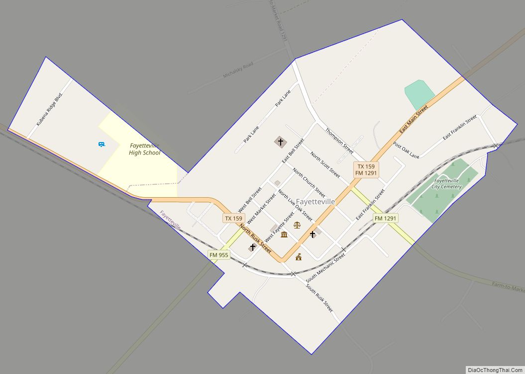
Fayetteville is a city in Fayette County, Texas. The population was 246 at the 2020 census.
| Name: | Fayetteville city |
|---|---|
| LSAD Code: | 25 |
| LSAD Description: | city (suffix) |
| State: | Texas |
| County: | Fayette County |
| Elevation: | 394 ft (120 m) |
| Total Area: | 0.50 sq mi (1.30 km²) |
| Land Area: | 0.50 sq mi (1.30 km²) |
| Water Area: | 0.00 sq mi (0.00 km²) |
| Total Population: | 258 |
| Population Density: | 511.95/sq mi (197.82/km²) |
| ZIP code: | 78940 |
| Area code: | 979 |
| FIPS code: | 4825644 |
| GNISfeature ID: | 1357269 |
| Website: | fayettevillecitytx.com |
Online Interactive Map
Click on ![]() to view map in "full screen" mode.
to view map in "full screen" mode.
Fayetteville location map. Where is Fayetteville city?


History
The town is located in an area that was originally granted to Alex Thompson and George Cumberland. Fayetteville’s first immigrant settlers were the families headed by John Crier, James Cummins, and James J. Ross, three of the Old Three Hundred. The settlement began at the location of a stagecoach stop on an old road between San Felipe and Bastrop.
Even though Fayette County was named after General Lafayette, the Revolutionary War hero, the community was named in 1844 after Fayetteville, North Carolina, for a prominent citizen of the time, who had surveyed the community, named its streets, and donated lots for the Fayetteville Academy and the town’s multidenominational Union Church.
Fayetteville was incorporated in 1882.
The town made national news during World War I. As reprinted by Stars and Stripes in its March 15, 1918 issue, the town’s mayor, W. C. Langlotz, and ten of the town’s citizens were charged with espionage. They were arrested following the display of the flag of the German Empire over the entryway of the Germania club in Fayetteville. The group pleaded “not guilty”: the mayor said the flag had been displayed by mistake.
The majority of the area within the town boundaries was designated the Fayetteville Historic District and listed on the National Register of Historic Places on July 10, 2008.
Fayetteville Road Map

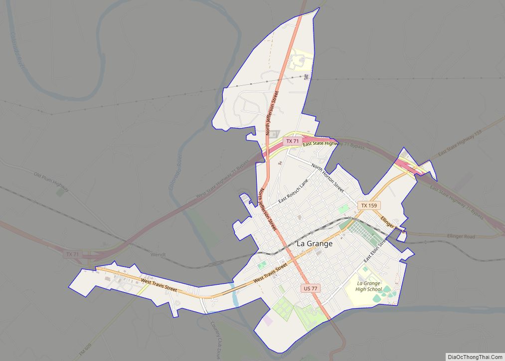
Fayetteville city Satellite Map

Geography
Fayetteville is located in eastern Fayette County at 29°54′18″N 96°40′30″W / 29.904922°N 96.675119°W / 29.904922; -96.675119 (29.904922, –96.675119). Texas State Highway 159 passes through the center of town, leading northeast 12 miles (19 km) to Industry and northwest, then southwest a total of 16 miles (26 km) to La Grange, the county seat. Houston is 85 miles (137 km) to the east via secondary highways and Interstate 10, while Austin is 80 miles (130 km) to the northwest via highways 159 and 71.
According to the United States Census Bureau, the city has a total area of 0.50 square miles (1.3 km), none of which is covered with water. Lake Fayette, a reservoir constructed for power generation, is 4 miles (6 km) west of town.
See also
Map of Texas State and its subdivision:- Anderson
- Andrews
- Angelina
- Aransas
- Archer
- Armstrong
- Atascosa
- Austin
- Bailey
- Bandera
- Bastrop
- Baylor
- Bee
- Bell
- Bexar
- Blanco
- Borden
- Bosque
- Bowie
- Brazoria
- Brazos
- Brewster
- Briscoe
- Brooks
- Brown
- Burleson
- Burnet
- Caldwell
- Calhoun
- Callahan
- Cameron
- Camp
- Carson
- Cass
- Castro
- Chambers
- Cherokee
- Childress
- Clay
- Cochran
- Coke
- Coleman
- Collin
- Collingsworth
- Colorado
- Comal
- Comanche
- Concho
- Cooke
- Coryell
- Cottle
- Crane
- Crockett
- Crosby
- Culberson
- Dallam
- Dallas
- Dawson
- Deaf Smith
- Delta
- Denton
- Dewitt
- Dickens
- Dimmit
- Donley
- Duval
- Eastland
- Ector
- Edwards
- El Paso
- Ellis
- Erath
- Falls
- Fannin
- Fayette
- Fisher
- Floyd
- Foard
- Fort Bend
- Franklin
- Freestone
- Frio
- Gaines
- Galveston
- Garza
- Gillespie
- Glasscock
- Goliad
- Gonzales
- Gray
- Grayson
- Gregg
- Grimes
- Guadalupe
- Hale
- Hall
- Hamilton
- Hansford
- Hardeman
- Hardin
- Harris
- Harrison
- Hartley
- Haskell
- Hays
- Hemphill
- Henderson
- Hidalgo
- Hill
- Hockley
- Hood
- Hopkins
- Houston
- Howard
- Hudspeth
- Hunt
- Hutchinson
- Irion
- Jack
- Jackson
- Jasper
- Jeff Davis
- Jefferson
- Jim Hogg
- Jim Wells
- Johnson
- Jones
- Karnes
- Kaufman
- Kendall
- Kenedy
- Kent
- Kerr
- Kimble
- King
- Kinney
- Kleberg
- Knox
- La Salle
- Lamar
- Lamb
- Lampasas
- Lavaca
- Lee
- Leon
- Liberty
- Limestone
- Lipscomb
- Live Oak
- Llano
- Loving
- Lubbock
- Lynn
- Madison
- Marion
- Martin
- Mason
- Matagorda
- Maverick
- McCulloch
- McLennan
- McMullen
- Medina
- Menard
- Midland
- Milam
- Mills
- Mitchell
- Montague
- Montgomery
- Moore
- Morris
- Motley
- Nacogdoches
- Navarro
- Newton
- Nolan
- Nueces
- Ochiltree
- Oldham
- Orange
- Palo Pinto
- Panola
- Parker
- Parmer
- Pecos
- Polk
- Potter
- Presidio
- Rains
- Randall
- Reagan
- Real
- Red River
- Reeves
- Refugio
- Roberts
- Robertson
- Rockwall
- Runnels
- Rusk
- Sabine
- San Augustine
- San Jacinto
- San Patricio
- San Saba
- Schleicher
- Scurry
- Shackelford
- Shelby
- Sherman
- Smith
- Somervell
- Starr
- Stephens
- Sterling
- Stonewall
- Sutton
- Swisher
- Tarrant
- Taylor
- Terrell
- Terry
- Throckmorton
- Titus
- Tom Green
- Travis
- Trinity
- Tyler
- Upshur
- Upton
- Uvalde
- Val Verde
- Van Zandt
- Victoria
- Walker
- Waller
- Ward
- Washington
- Webb
- Wharton
- Wheeler
- Wichita
- Wilbarger
- Willacy
- Williamson
- Wilson
- Winkler
- Wise
- Wood
- Yoakum
- Young
- Zapata
- Zavala
- Alabama
- Alaska
- Arizona
- Arkansas
- California
- Colorado
- Connecticut
- Delaware
- District of Columbia
- Florida
- Georgia
- Hawaii
- Idaho
- Illinois
- Indiana
- Iowa
- Kansas
- Kentucky
- Louisiana
- Maine
- Maryland
- Massachusetts
- Michigan
- Minnesota
- Mississippi
- Missouri
- Montana
- Nebraska
- Nevada
- New Hampshire
- New Jersey
- New Mexico
- New York
- North Carolina
- North Dakota
- Ohio
- Oklahoma
- Oregon
- Pennsylvania
- Rhode Island
- South Carolina
- South Dakota
- Tennessee
- Texas
- Utah
- Vermont
- Virginia
- Washington
- West Virginia
- Wisconsin
- Wyoming