Hebron is a town in Denton County in the U.S. state of Texas with a small disconnected section in Collin County. The population was 415 at the 2010 census.
| Name: | Hebron town |
|---|---|
| LSAD Code: | 43 |
| LSAD Description: | town (suffix) |
| State: | Texas |
| County: | Collin County, Denton County |
| Elevation: | 577 ft (176 m) |
| Total Area: | 0.33 sq mi (0.85 km²) |
| Land Area: | 0.33 sq mi (0.85 km²) |
| Water Area: | 0.00 sq mi (0.00 km²) |
| Total Population: | 415 |
| Population Density: | 653.50/sq mi (252.45/km²) |
| FIPS code: | 4833020 |
| GNISfeature ID: | 1378433 |
Online Interactive Map
Click on ![]() to view map in "full screen" mode.
to view map in "full screen" mode.
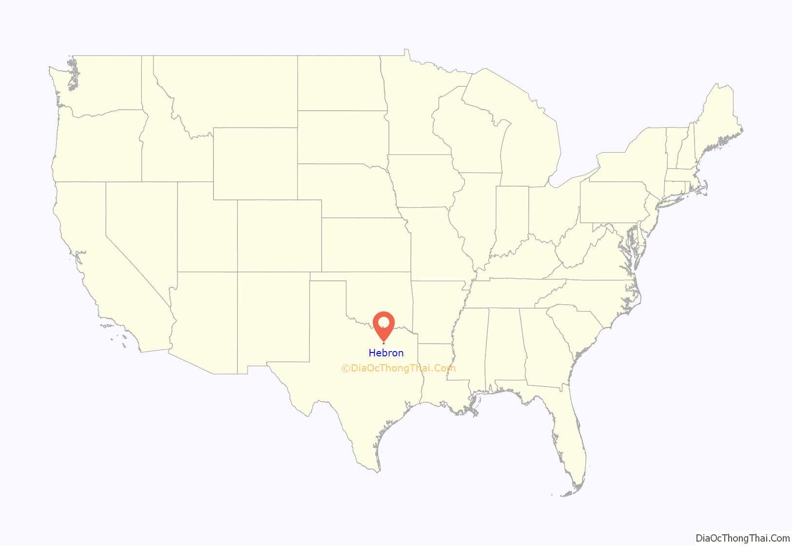
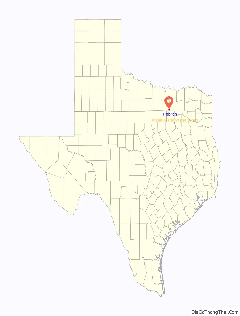
Hebron location map. Where is Hebron town?
History
Hebron was founded in the 1890s and was alternatively known as “Shepton”. The land was donated by the Blackland Townsite Company, a subsidiary of the St. Louis and San Francisco Railroad. Historically, the town center was based near the intersection of two railroads, near present-day East Hebron Parkway and 1st Street. Much of that town center has been cleared and developed.
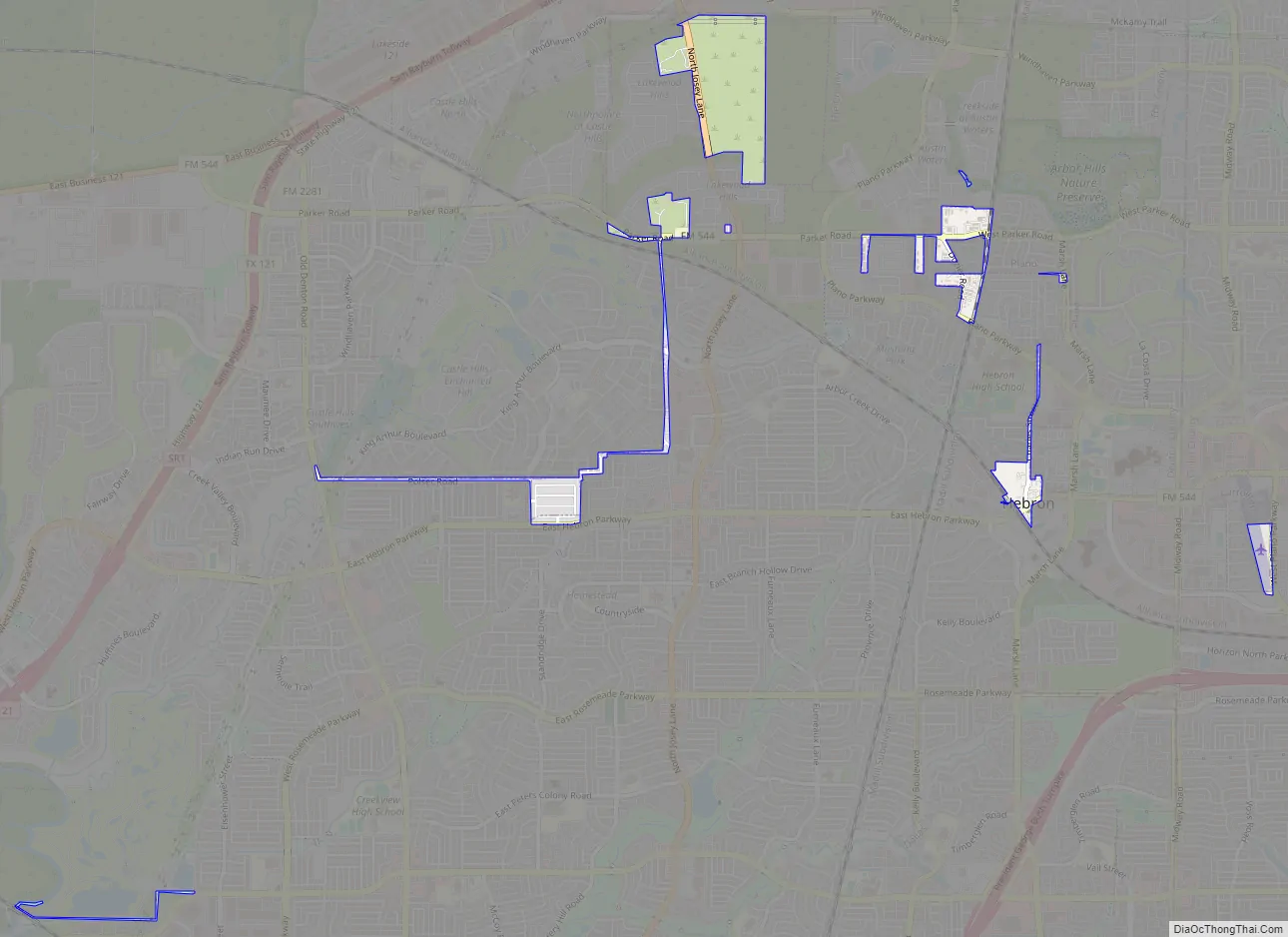
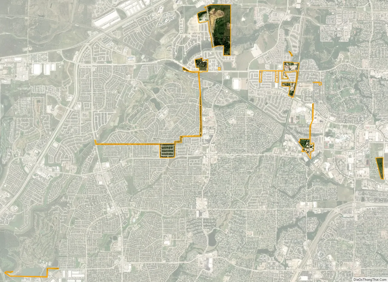
The town was first incorporated in 1961 as a method to prevent Plano and Carrollton from annexing the territory and imposing taxes. The city of Hebron imposed no taxes of its own, and when the time was ripe for a landowner to develop his land, he would ask the town to disannex that parcel. Hebron’s city limits once covered about 25 square miles (65 km) from the Collin County line west to the Trinity River and from the Dallas County line north to State Highway 121. Now it comprises a few plots of land connected with narrow strips and easements, which confuses many maps. Stanley Dozier, the namesake of Dozier Road, was the only mayor of the town between 1961 and 1997. The town is currently managed by a three-person commission with Kelly Clem as the mayor.
Air Park-Dallas Airport was built as a public civilian airstrip within the city limits in 1965.
For the last 20 years, Hebron has disannexed large portions of its territory to be annexed by neighboring communities (Lewisville, The Colony, Carrollton, and Plano) instead. The original goal was for Hebron to disappear entirely as an incorporated community, but recently elected leaders have attempted to reverse the situation and allow Hebron to continue as a town. This is partially in response to the city of Carrollton’s threatening not to maintain the water supply unless the town is annexed to Carrollton.
Hebron Road Map
Hebron city Satellite Map
Geography
Hebron is located in southeastern Denton County at 33°1′42″N 96°53′55″W / 33.02833°N 96.89861°W / 33.02833; -96.89861 (33.028460, –96.898564). A small, disconnected piece of the town is in southwestern Collin County.
According to the United States Census Bureau, the town has a total area of 1.30 square miles (3.36 km), of which 0.01 square miles (0.02 km), or 0.68%, is covered by water.
See also
Map of Texas State and its subdivision:- Anderson
- Andrews
- Angelina
- Aransas
- Archer
- Armstrong
- Atascosa
- Austin
- Bailey
- Bandera
- Bastrop
- Baylor
- Bee
- Bell
- Bexar
- Blanco
- Borden
- Bosque
- Bowie
- Brazoria
- Brazos
- Brewster
- Briscoe
- Brooks
- Brown
- Burleson
- Burnet
- Caldwell
- Calhoun
- Callahan
- Cameron
- Camp
- Carson
- Cass
- Castro
- Chambers
- Cherokee
- Childress
- Clay
- Cochran
- Coke
- Coleman
- Collin
- Collingsworth
- Colorado
- Comal
- Comanche
- Concho
- Cooke
- Coryell
- Cottle
- Crane
- Crockett
- Crosby
- Culberson
- Dallam
- Dallas
- Dawson
- Deaf Smith
- Delta
- Denton
- Dewitt
- Dickens
- Dimmit
- Donley
- Duval
- Eastland
- Ector
- Edwards
- El Paso
- Ellis
- Erath
- Falls
- Fannin
- Fayette
- Fisher
- Floyd
- Foard
- Fort Bend
- Franklin
- Freestone
- Frio
- Gaines
- Galveston
- Garza
- Gillespie
- Glasscock
- Goliad
- Gonzales
- Gray
- Grayson
- Gregg
- Grimes
- Guadalupe
- Hale
- Hall
- Hamilton
- Hansford
- Hardeman
- Hardin
- Harris
- Harrison
- Hartley
- Haskell
- Hays
- Hemphill
- Henderson
- Hidalgo
- Hill
- Hockley
- Hood
- Hopkins
- Houston
- Howard
- Hudspeth
- Hunt
- Hutchinson
- Irion
- Jack
- Jackson
- Jasper
- Jeff Davis
- Jefferson
- Jim Hogg
- Jim Wells
- Johnson
- Jones
- Karnes
- Kaufman
- Kendall
- Kenedy
- Kent
- Kerr
- Kimble
- King
- Kinney
- Kleberg
- Knox
- La Salle
- Lamar
- Lamb
- Lampasas
- Lavaca
- Lee
- Leon
- Liberty
- Limestone
- Lipscomb
- Live Oak
- Llano
- Loving
- Lubbock
- Lynn
- Madison
- Marion
- Martin
- Mason
- Matagorda
- Maverick
- McCulloch
- McLennan
- McMullen
- Medina
- Menard
- Midland
- Milam
- Mills
- Mitchell
- Montague
- Montgomery
- Moore
- Morris
- Motley
- Nacogdoches
- Navarro
- Newton
- Nolan
- Nueces
- Ochiltree
- Oldham
- Orange
- Palo Pinto
- Panola
- Parker
- Parmer
- Pecos
- Polk
- Potter
- Presidio
- Rains
- Randall
- Reagan
- Real
- Red River
- Reeves
- Refugio
- Roberts
- Robertson
- Rockwall
- Runnels
- Rusk
- Sabine
- San Augustine
- San Jacinto
- San Patricio
- San Saba
- Schleicher
- Scurry
- Shackelford
- Shelby
- Sherman
- Smith
- Somervell
- Starr
- Stephens
- Sterling
- Stonewall
- Sutton
- Swisher
- Tarrant
- Taylor
- Terrell
- Terry
- Throckmorton
- Titus
- Tom Green
- Travis
- Trinity
- Tyler
- Upshur
- Upton
- Uvalde
- Val Verde
- Van Zandt
- Victoria
- Walker
- Waller
- Ward
- Washington
- Webb
- Wharton
- Wheeler
- Wichita
- Wilbarger
- Willacy
- Williamson
- Wilson
- Winkler
- Wise
- Wood
- Yoakum
- Young
- Zapata
- Zavala
- Alabama
- Alaska
- Arizona
- Arkansas
- California
- Colorado
- Connecticut
- Delaware
- District of Columbia
- Florida
- Georgia
- Hawaii
- Idaho
- Illinois
- Indiana
- Iowa
- Kansas
- Kentucky
- Louisiana
- Maine
- Maryland
- Massachusetts
- Michigan
- Minnesota
- Mississippi
- Missouri
- Montana
- Nebraska
- Nevada
- New Hampshire
- New Jersey
- New Mexico
- New York
- North Carolina
- North Dakota
- Ohio
- Oklahoma
- Oregon
- Pennsylvania
- Rhode Island
- South Carolina
- South Dakota
- Tennessee
- Texas
- Utah
- Vermont
- Virginia
- Washington
- West Virginia
- Wisconsin
- Wyoming


