Highland Park is a town in central Dallas County, Texas, United States. The population was 8,864 in 2020. It is located between the Dallas North Tollway and U.S. Route 75 (North Central Expressway), 4 miles (6 km) north of downtown Dallas.
Highland Park is bordered on the south, east and west by Dallas and on the north by the city of University Park. Highland Park and University Park together comprise the Park Cities, an enclave of Dallas.
Highland Park did not have any homeowners who were black until 2003. The town has been known as a “sundown town”.
| Name: | Highland Park town |
|---|---|
| LSAD Code: | 43 |
| LSAD Description: | town (suffix) |
| State: | Texas |
| County: | Dallas County |
| Elevation: | 528 ft (161 m) |
| Total Area: | 2.24 sq mi (5.81 km²) |
| Land Area: | 2.24 sq mi (5.81 km²) |
| Water Area: | 0.00 sq mi (0.00 km²) |
| Total Population: | 8,564 |
| Population Density: | 4,049.49/sq mi (1,563.45/km²) |
| ZIP code: | 75205, 75209, 75219, 75225 |
| Area code: | 214, 469, 945, 972 |
| FIPS code: | 4833824 |
| GNISfeature ID: | 1388240 |
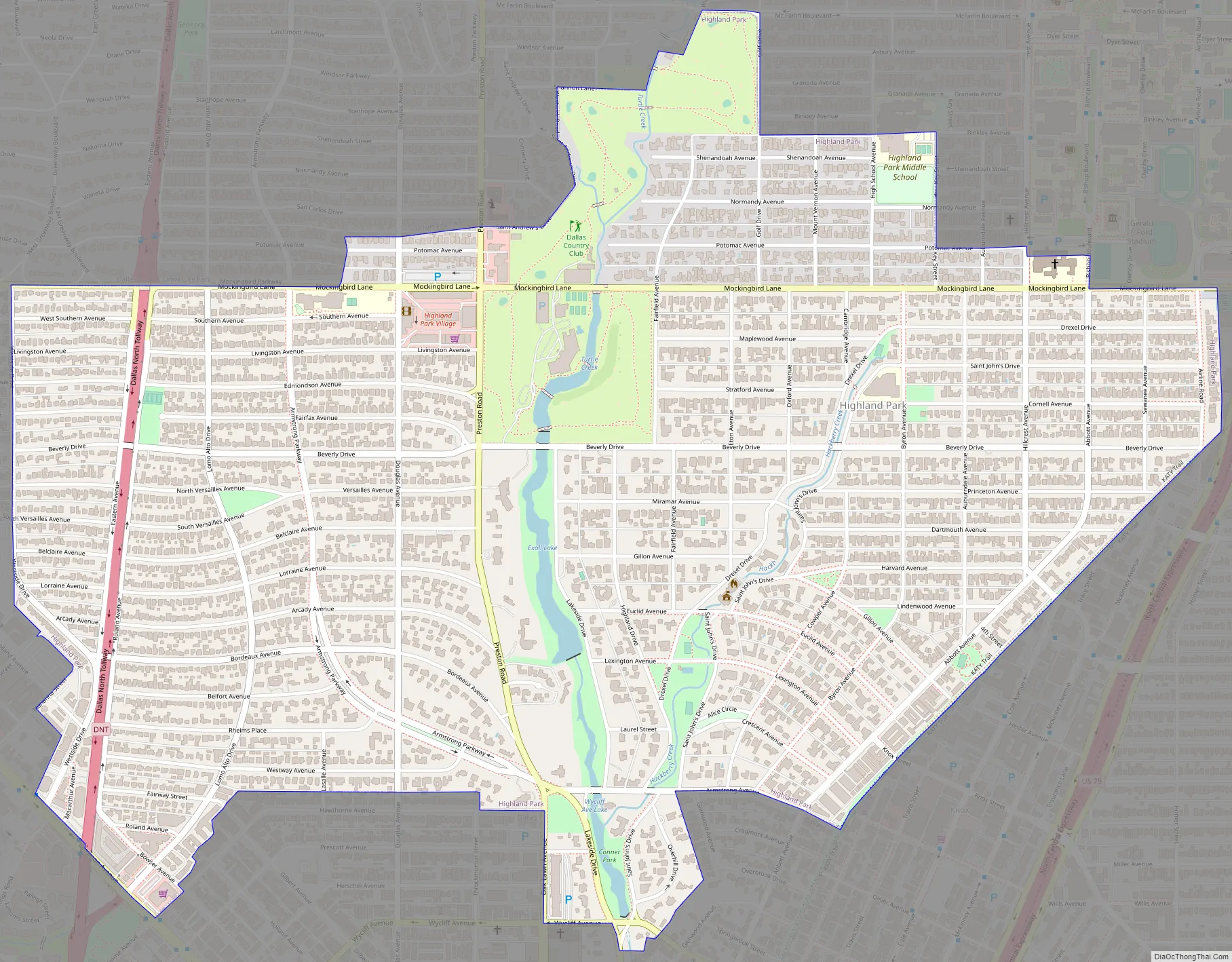
Online Interactive Map
Click on ![]() to view map in "full screen" mode.
to view map in "full screen" mode.
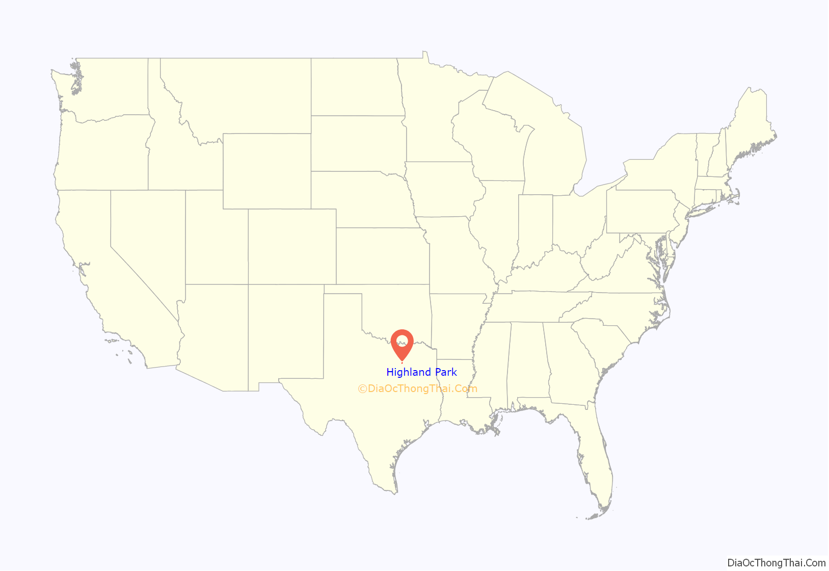
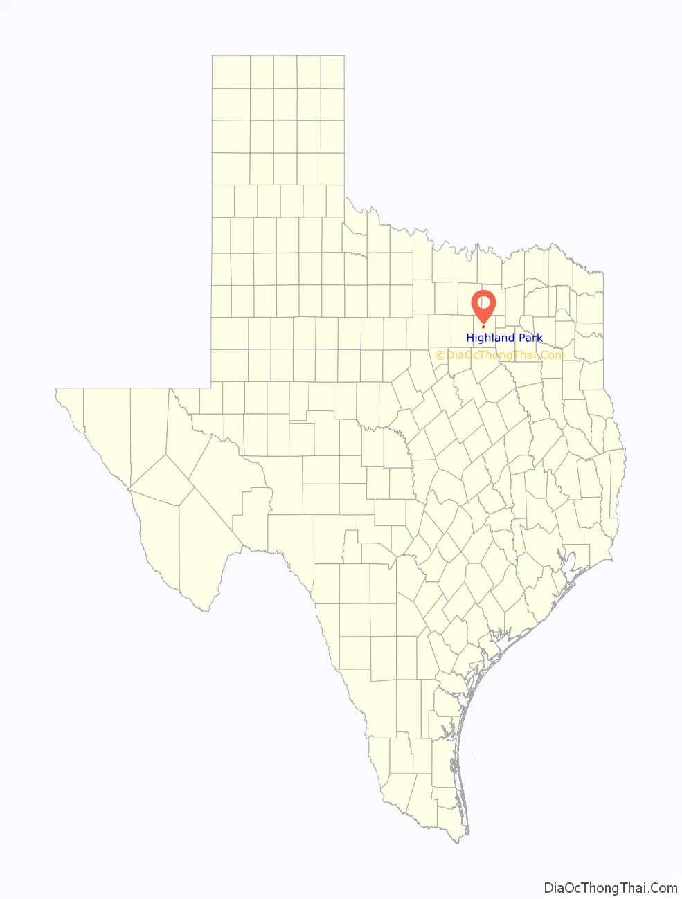
Highland Park location map. Where is Highland Park town?
History
The land now known as Highland Park was bought in 1889 by a group of investors from Philadelphia, Pennsylvania, known as the Philadelphia Place Land Association, for an average price of $377 an acre, with a total of $500,000. Henry Exall, an agent, intended to develop the land along Turtle Creek as “Philadelphia Place”, exclusive housing based on parkland areas in Philadelphia. He laid gravel roads, and dammed Turtle Creek, forming Exall Lake, before the Panic of 1893 brought a blow to his fortunes, halting development. Afterwards, he began a horse breeding farm. In the 1890s, Exall Lake was a common picnic destination for Dallas residents.
In 1906, John S. Armstrong (the former partner of Thomas Marsalis, the developer of Oak Cliff), sold his meatpacking business and invested his money in a portion of the former Philadelphia Place land, to develop it under the name of “Highland Park”. He chose this name as it was located on high land that overlooked downtown Dallas. Wilbur David Cook, the landscape designer who had planned Beverly Hills, California, and George E. Kessler, who had previously planned Fair Park and most of downtown Dallas, were hired to design its layout in 1907. Notably, twenty percent of the original land was set aside for parks. A second development in Highland Park was developed in 1910.
In 1913, Highland Park petitioned Dallas for annexation, but was refused. The 500 residents voted to incorporate on November 29, 1913, and incorporation was granted in 1915, when its population was 1,100. The first mayor of Highland Park was W. A. Fraser. A third and fourth development were added to the town in 1915 and 1917, respectively. In 1919, the city of Dallas sought to annex Highland Park, beginning a lengthy controversy that lasted until 1945. J. W. Bartholow and William Chloupek led the fight to resist the annexation. The final major land development occurred in 1924. In 1931, Highland Park Village was constructed, the first shopping center of its kind in the United States.
Because of its location near Dallas, Highland Park had, by the early 1930s, developed a moderately large (8,400) population, with a few businesses. Eventually the school districts and newspapers of Highland Park and University Park were combined. In the 1940s, after the failure to annex Highland Park, Dallas began annexing the land surrounding it. Reaching a population high of just under 13,000 in the late 1950s, Highland Park afterwards grew only by building houses on the remaining vacant lots, and by the destruction of old buildings. Since 1990, Highland Park has maintained strict zoning ordinances.
Highland Park Road Map
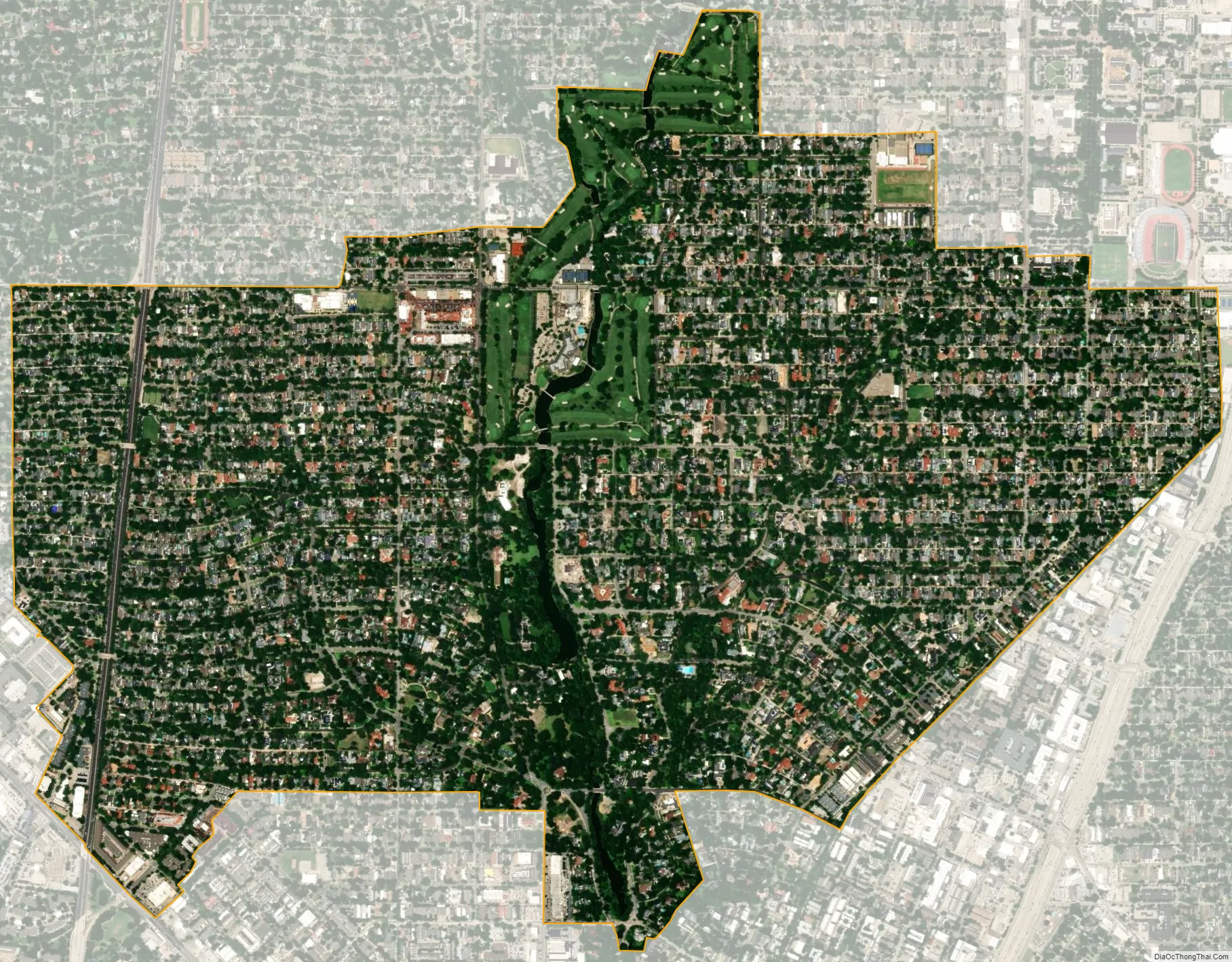
Highland Park city Satellite Map
Geography
According to the United States Census Bureau, the town has a total area of 2.2 square miles (5.7 km), all of it land. Highland Park is about 3 miles (4.8 km) north of the center of Dallas.
Neighborhoods
Highland Park was first developed as Old Highland which is made up of the First Section, Second Section, Turtle Creek Acreage, Acreage Section, Third Section, Fourth Section, and the Hackberry Creek Acreage of Old Highland Park. And then the Highland Park Neighborhoods West of Preston were developed.
Climate
The climate in this area is characterized by hot, humid summers and generally mild to cool winters. According to the Köppen Climate Classification system, Highland Park has a humid subtropical climate, abbreviated “Cfa” on climate maps.
See also
Map of Texas State and its subdivision:- Anderson
- Andrews
- Angelina
- Aransas
- Archer
- Armstrong
- Atascosa
- Austin
- Bailey
- Bandera
- Bastrop
- Baylor
- Bee
- Bell
- Bexar
- Blanco
- Borden
- Bosque
- Bowie
- Brazoria
- Brazos
- Brewster
- Briscoe
- Brooks
- Brown
- Burleson
- Burnet
- Caldwell
- Calhoun
- Callahan
- Cameron
- Camp
- Carson
- Cass
- Castro
- Chambers
- Cherokee
- Childress
- Clay
- Cochran
- Coke
- Coleman
- Collin
- Collingsworth
- Colorado
- Comal
- Comanche
- Concho
- Cooke
- Coryell
- Cottle
- Crane
- Crockett
- Crosby
- Culberson
- Dallam
- Dallas
- Dawson
- Deaf Smith
- Delta
- Denton
- Dewitt
- Dickens
- Dimmit
- Donley
- Duval
- Eastland
- Ector
- Edwards
- El Paso
- Ellis
- Erath
- Falls
- Fannin
- Fayette
- Fisher
- Floyd
- Foard
- Fort Bend
- Franklin
- Freestone
- Frio
- Gaines
- Galveston
- Garza
- Gillespie
- Glasscock
- Goliad
- Gonzales
- Gray
- Grayson
- Gregg
- Grimes
- Guadalupe
- Hale
- Hall
- Hamilton
- Hansford
- Hardeman
- Hardin
- Harris
- Harrison
- Hartley
- Haskell
- Hays
- Hemphill
- Henderson
- Hidalgo
- Hill
- Hockley
- Hood
- Hopkins
- Houston
- Howard
- Hudspeth
- Hunt
- Hutchinson
- Irion
- Jack
- Jackson
- Jasper
- Jeff Davis
- Jefferson
- Jim Hogg
- Jim Wells
- Johnson
- Jones
- Karnes
- Kaufman
- Kendall
- Kenedy
- Kent
- Kerr
- Kimble
- King
- Kinney
- Kleberg
- Knox
- La Salle
- Lamar
- Lamb
- Lampasas
- Lavaca
- Lee
- Leon
- Liberty
- Limestone
- Lipscomb
- Live Oak
- Llano
- Loving
- Lubbock
- Lynn
- Madison
- Marion
- Martin
- Mason
- Matagorda
- Maverick
- McCulloch
- McLennan
- McMullen
- Medina
- Menard
- Midland
- Milam
- Mills
- Mitchell
- Montague
- Montgomery
- Moore
- Morris
- Motley
- Nacogdoches
- Navarro
- Newton
- Nolan
- Nueces
- Ochiltree
- Oldham
- Orange
- Palo Pinto
- Panola
- Parker
- Parmer
- Pecos
- Polk
- Potter
- Presidio
- Rains
- Randall
- Reagan
- Real
- Red River
- Reeves
- Refugio
- Roberts
- Robertson
- Rockwall
- Runnels
- Rusk
- Sabine
- San Augustine
- San Jacinto
- San Patricio
- San Saba
- Schleicher
- Scurry
- Shackelford
- Shelby
- Sherman
- Smith
- Somervell
- Starr
- Stephens
- Sterling
- Stonewall
- Sutton
- Swisher
- Tarrant
- Taylor
- Terrell
- Terry
- Throckmorton
- Titus
- Tom Green
- Travis
- Trinity
- Tyler
- Upshur
- Upton
- Uvalde
- Val Verde
- Van Zandt
- Victoria
- Walker
- Waller
- Ward
- Washington
- Webb
- Wharton
- Wheeler
- Wichita
- Wilbarger
- Willacy
- Williamson
- Wilson
- Winkler
- Wise
- Wood
- Yoakum
- Young
- Zapata
- Zavala
- Alabama
- Alaska
- Arizona
- Arkansas
- California
- Colorado
- Connecticut
- Delaware
- District of Columbia
- Florida
- Georgia
- Hawaii
- Idaho
- Illinois
- Indiana
- Iowa
- Kansas
- Kentucky
- Louisiana
- Maine
- Maryland
- Massachusetts
- Michigan
- Minnesota
- Mississippi
- Missouri
- Montana
- Nebraska
- Nevada
- New Hampshire
- New Jersey
- New Mexico
- New York
- North Carolina
- North Dakota
- Ohio
- Oklahoma
- Oregon
- Pennsylvania
- Rhode Island
- South Carolina
- South Dakota
- Tennessee
- Texas
- Utah
- Vermont
- Virginia
- Washington
- West Virginia
- Wisconsin
- Wyoming