Irving is a city in the U.S. state of Texas. Located in Dallas County, it is also an inner ring suburb of Dallas. The city of Irving is part of the Dallas–Fort Worth metroplex. According to a 2019 estimate from the United States Census Bureau, the city population was 239,798, making it the thirteenth-most populous city in Texas, and 93rd most populous city in the U.S. Irving is noted for its racial and ethnic diversity, and has been ranked as one of the most diverse cities in the United States. Irving includes the Las Colinas mixed-use master-planned community and part of the Dallas/Fort Worth International Airport.
| Name: | Irving city |
|---|---|
| LSAD Code: | 25 |
| LSAD Description: | city (suffix) |
| State: | Texas |
| County: | Dallas County |
| Elevation: | 482 ft (147 m) |
| Land Area: | 66.98 sq mi (173.48 km²) |
| Water Area: | 0.99 sq mi (2.57 km²) |
| Population Density: | 3,580.20/sq mi (1,382.32/km²) |
| Area code: | 214, 469, 945, 972, 682, 817 |
| FIPS code: | 4837000 |
| GNISfeature ID: | 1338507 |
| Website: | cityofirving.org |
Online Interactive Map
Click on ![]() to view map in "full screen" mode.
to view map in "full screen" mode.
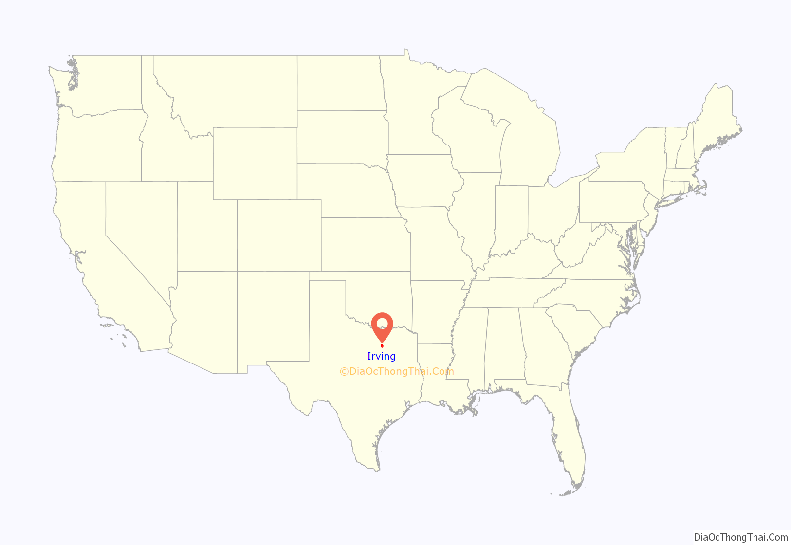
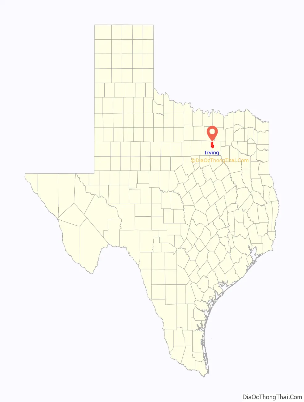
Irving location map. Where is Irving city?
History
Irving was founded in 1903 by J.O. “Otto” Schulze and Otis Brown. It is believed literary author Washington Irving was a favorite of Netta Barcus Brown, and consequently the name of the town site, Irving, was chosen. Irving began in 1889 as an area called Gorbit, and in 1894 the name changed to Kit. Irving was incorporated April 14, 1914, with Otis Brown as the first mayor.
By the late nineteenth century the Irving area was the site of churches, two cotton gins, a blacksmith shop and a general store. The Irving district public school system dates to the 1909 establishment of Kit and Lively schools. Population growth was slow and sometimes halting, with only 357 residents in 1925, but a significant increase began in the 1930s.
By the early 1960s the city had a population of approximately 45,000. A number of manufacturing plants operated in Irving, along with transportation, retail and financial businesses. The University of Dallas in Irving opened in 1956, and Texas Stadium was completed in 1971 as the home field of the Dallas Cowboys. The Chateau Theater opened in 1964 as part of a chain of premium, dollar, and drive-in theaters that stretched across North Texas and Oklahoma.
Delta Air Lines Flight 191 crashed in Irving on August 2, 1985.
Irving’s population reached 155,037 in 1990 and the United States Census Bureau estimated 236,607 residents in 2016, a 3.5 percent population increase over 2013 census estimates.
In 2000, an Oshman’s Sporting Goods store was robbed by the “Texas Seven”. In 2011, the Irving Convention Center at Las Colinas opened. Four years later high-school student Ahmed Mohamed was the subject of a hoax bomb incident which ignited allegations of racial profiling and Islamophobia from many media and commentators.
In 2019, Irving completed its construction of an entertainment district in Las Colinas with the opening of the Westin Irving Convention Center Hotel. The entertainment district also includes the Irving Convention Center at Las Colinas and the Toyota Music Factory, an entertainment complex with numerous restaurants, an Alamo Drafthouse Cinema, the Texas Lottery Plaza open-air performance stage and the Pavilion at the Toyota Music Factory concert venue.
On May 8, 2020, the city’s local poultry plant run by Westfield, Wisconsin-based Brakebush Bros. Inc reported 40 cases of COVID-19 among its workers during the 2019–2020 coronavirus pandemic.
Irving Road Map
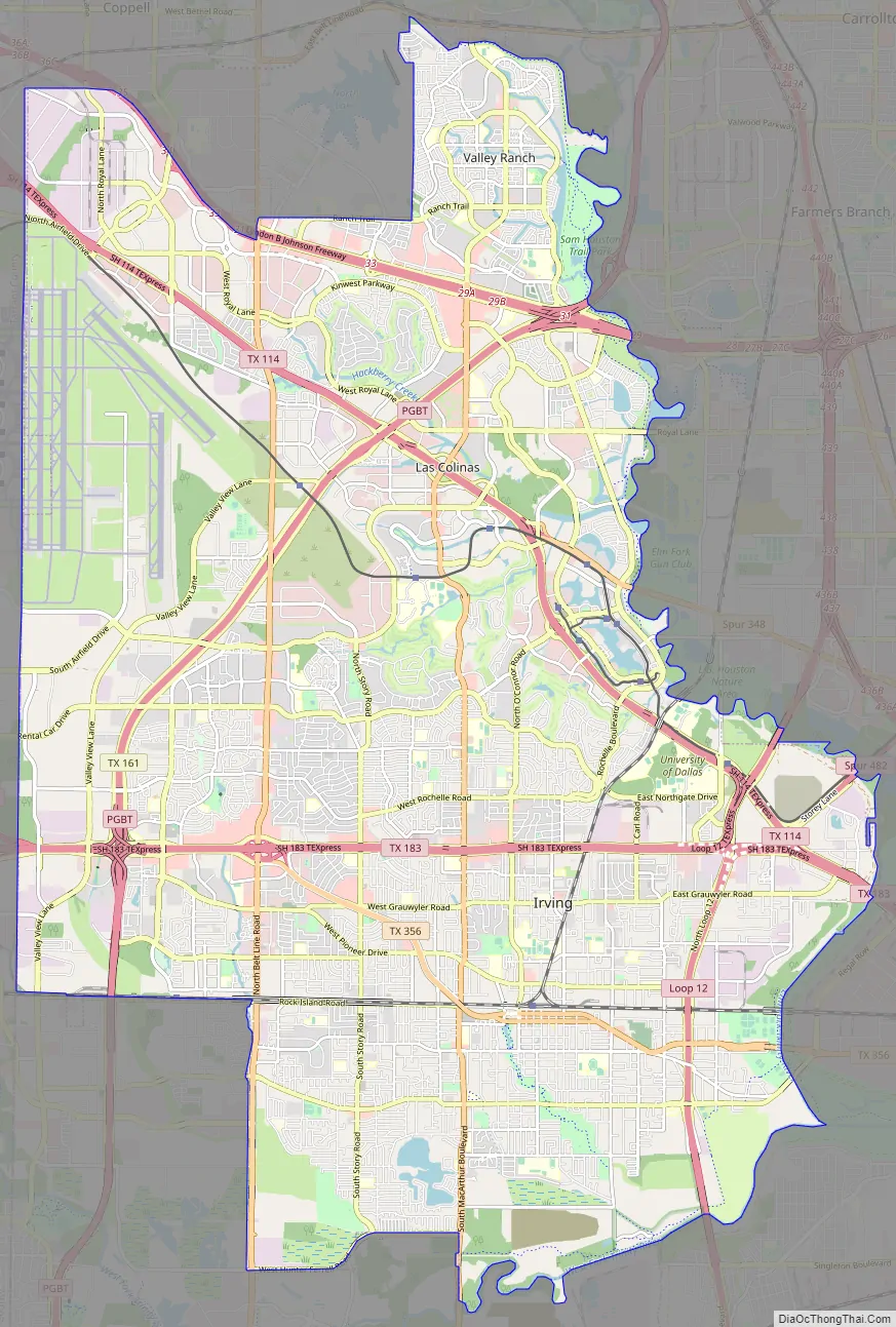
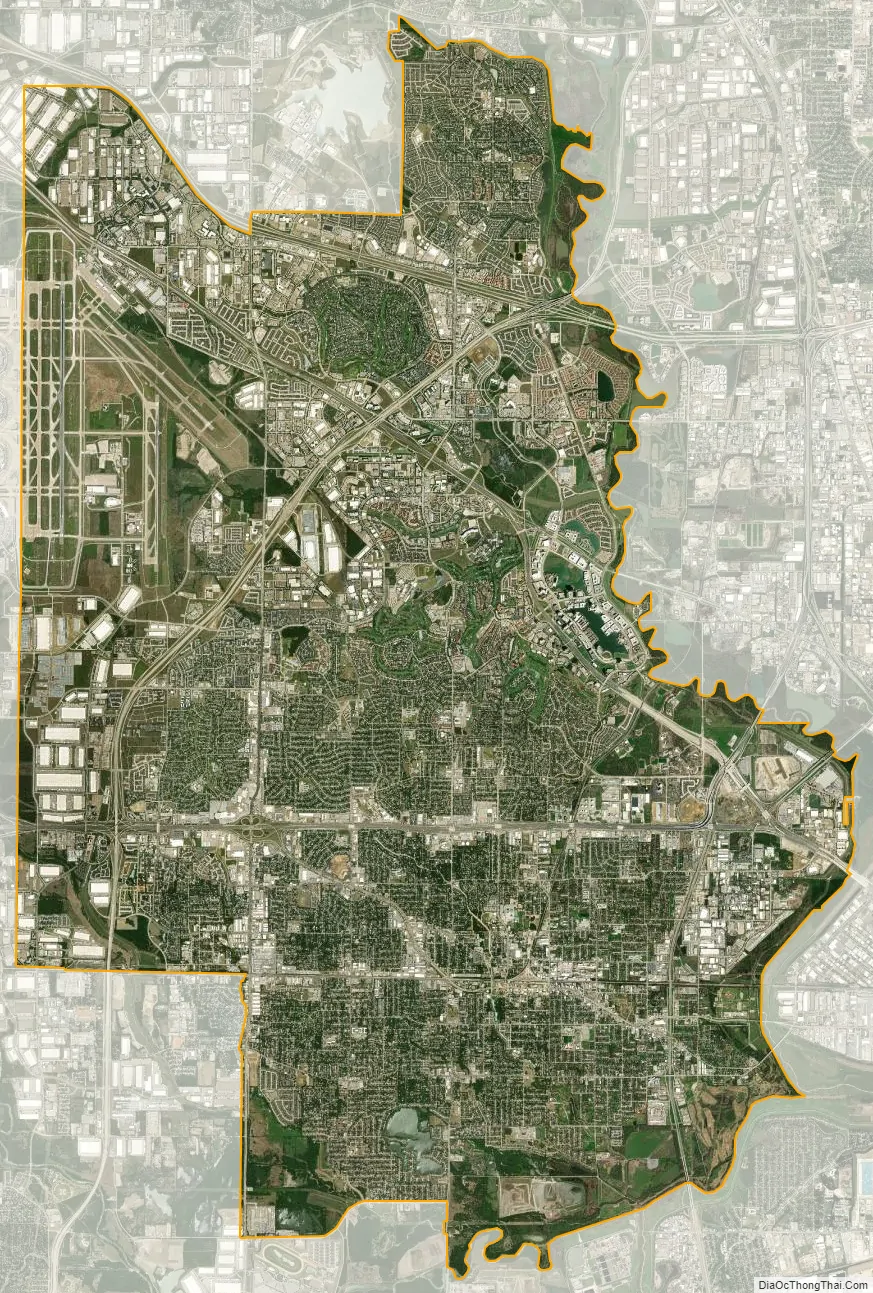
Irving city Satellite Map
Geography
According to the United States Census Bureau, the city has a total area of 67.7 square miles (175 km), of which 67.2 square miles (174 km) of it is land and 0.4 square miles (1.0 km) of it (0.65%) is water.
Developments
Irving includes the Las Colinas planned community, a mixed-use development with a land area of more than 12,000 acres (4,856 ha) that is home to many Fortune 500 companies and the Las Colinas Entertainment District. It also includes part of the Dallas/Fort Worth International Airport.
Climate
The warmest month on average is July, and the highest recorded temperature was 112 °F (44 °C) in 1980. The average coolest month is January, and the lowest recorded temperature was −8 °F (−22 °C) in 1899. Irving is considered to be part of the humid subtropical region. May is the average wettest month.
See also
Map of Texas State and its subdivision:- Anderson
- Andrews
- Angelina
- Aransas
- Archer
- Armstrong
- Atascosa
- Austin
- Bailey
- Bandera
- Bastrop
- Baylor
- Bee
- Bell
- Bexar
- Blanco
- Borden
- Bosque
- Bowie
- Brazoria
- Brazos
- Brewster
- Briscoe
- Brooks
- Brown
- Burleson
- Burnet
- Caldwell
- Calhoun
- Callahan
- Cameron
- Camp
- Carson
- Cass
- Castro
- Chambers
- Cherokee
- Childress
- Clay
- Cochran
- Coke
- Coleman
- Collin
- Collingsworth
- Colorado
- Comal
- Comanche
- Concho
- Cooke
- Coryell
- Cottle
- Crane
- Crockett
- Crosby
- Culberson
- Dallam
- Dallas
- Dawson
- Deaf Smith
- Delta
- Denton
- Dewitt
- Dickens
- Dimmit
- Donley
- Duval
- Eastland
- Ector
- Edwards
- El Paso
- Ellis
- Erath
- Falls
- Fannin
- Fayette
- Fisher
- Floyd
- Foard
- Fort Bend
- Franklin
- Freestone
- Frio
- Gaines
- Galveston
- Garza
- Gillespie
- Glasscock
- Goliad
- Gonzales
- Gray
- Grayson
- Gregg
- Grimes
- Guadalupe
- Hale
- Hall
- Hamilton
- Hansford
- Hardeman
- Hardin
- Harris
- Harrison
- Hartley
- Haskell
- Hays
- Hemphill
- Henderson
- Hidalgo
- Hill
- Hockley
- Hood
- Hopkins
- Houston
- Howard
- Hudspeth
- Hunt
- Hutchinson
- Irion
- Jack
- Jackson
- Jasper
- Jeff Davis
- Jefferson
- Jim Hogg
- Jim Wells
- Johnson
- Jones
- Karnes
- Kaufman
- Kendall
- Kenedy
- Kent
- Kerr
- Kimble
- King
- Kinney
- Kleberg
- Knox
- La Salle
- Lamar
- Lamb
- Lampasas
- Lavaca
- Lee
- Leon
- Liberty
- Limestone
- Lipscomb
- Live Oak
- Llano
- Loving
- Lubbock
- Lynn
- Madison
- Marion
- Martin
- Mason
- Matagorda
- Maverick
- McCulloch
- McLennan
- McMullen
- Medina
- Menard
- Midland
- Milam
- Mills
- Mitchell
- Montague
- Montgomery
- Moore
- Morris
- Motley
- Nacogdoches
- Navarro
- Newton
- Nolan
- Nueces
- Ochiltree
- Oldham
- Orange
- Palo Pinto
- Panola
- Parker
- Parmer
- Pecos
- Polk
- Potter
- Presidio
- Rains
- Randall
- Reagan
- Real
- Red River
- Reeves
- Refugio
- Roberts
- Robertson
- Rockwall
- Runnels
- Rusk
- Sabine
- San Augustine
- San Jacinto
- San Patricio
- San Saba
- Schleicher
- Scurry
- Shackelford
- Shelby
- Sherman
- Smith
- Somervell
- Starr
- Stephens
- Sterling
- Stonewall
- Sutton
- Swisher
- Tarrant
- Taylor
- Terrell
- Terry
- Throckmorton
- Titus
- Tom Green
- Travis
- Trinity
- Tyler
- Upshur
- Upton
- Uvalde
- Val Verde
- Van Zandt
- Victoria
- Walker
- Waller
- Ward
- Washington
- Webb
- Wharton
- Wheeler
- Wichita
- Wilbarger
- Willacy
- Williamson
- Wilson
- Winkler
- Wise
- Wood
- Yoakum
- Young
- Zapata
- Zavala
- Alabama
- Alaska
- Arizona
- Arkansas
- California
- Colorado
- Connecticut
- Delaware
- District of Columbia
- Florida
- Georgia
- Hawaii
- Idaho
- Illinois
- Indiana
- Iowa
- Kansas
- Kentucky
- Louisiana
- Maine
- Maryland
- Massachusetts
- Michigan
- Minnesota
- Mississippi
- Missouri
- Montana
- Nebraska
- Nevada
- New Hampshire
- New Jersey
- New Mexico
- New York
- North Carolina
- North Dakota
- Ohio
- Oklahoma
- Oregon
- Pennsylvania
- Rhode Island
- South Carolina
- South Dakota
- Tennessee
- Texas
- Utah
- Vermont
- Virginia
- Washington
- West Virginia
- Wisconsin
- Wyoming