Alvin is a city in the U.S. state of Texas within the Houston-The Woodlands-Sugar Land metropolitan area and Brazoria County. As of the 2020 U.S. Census, the city population was 27,098. Alvin’s claim to fame is Baseball Hall of Famer Nolan Ryan, who moved with his family to the city in 1947 as an infant and lived there until he moved to Round Rock in 2003. The Nolan Ryan Museum is in the Nolan Ryan Foundation and Exhibit Center on the campus of Alvin Community College.
| Name: | Alvin city |
|---|---|
| LSAD Code: | 25 |
| LSAD Description: | city (suffix) |
| State: | Texas |
| County: | Brazoria County |
| Incorporated: | 1893 |
| Elevation: | 43 ft (13 m) |
| Total Area: | 25.14 sq mi (65.11 km²) |
| Land Area: | 24.27 sq mi (62.85 km²) |
| Water Area: | 0.87 sq mi (2.26 km²) |
| Total Population: | 27,098 |
| Population Density: | 1,101.21/sq mi (425.18/km²) |
| ZIP code: | 77511-77512 |
| Area code: | 281 |
| FIPS code: | 4802272 |
| GNISfeature ID: | 1329478 |
| Website: | www.alvin-tx.gov |
Online Interactive Map
Click on ![]() to view map in "full screen" mode.
to view map in "full screen" mode.
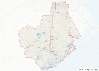
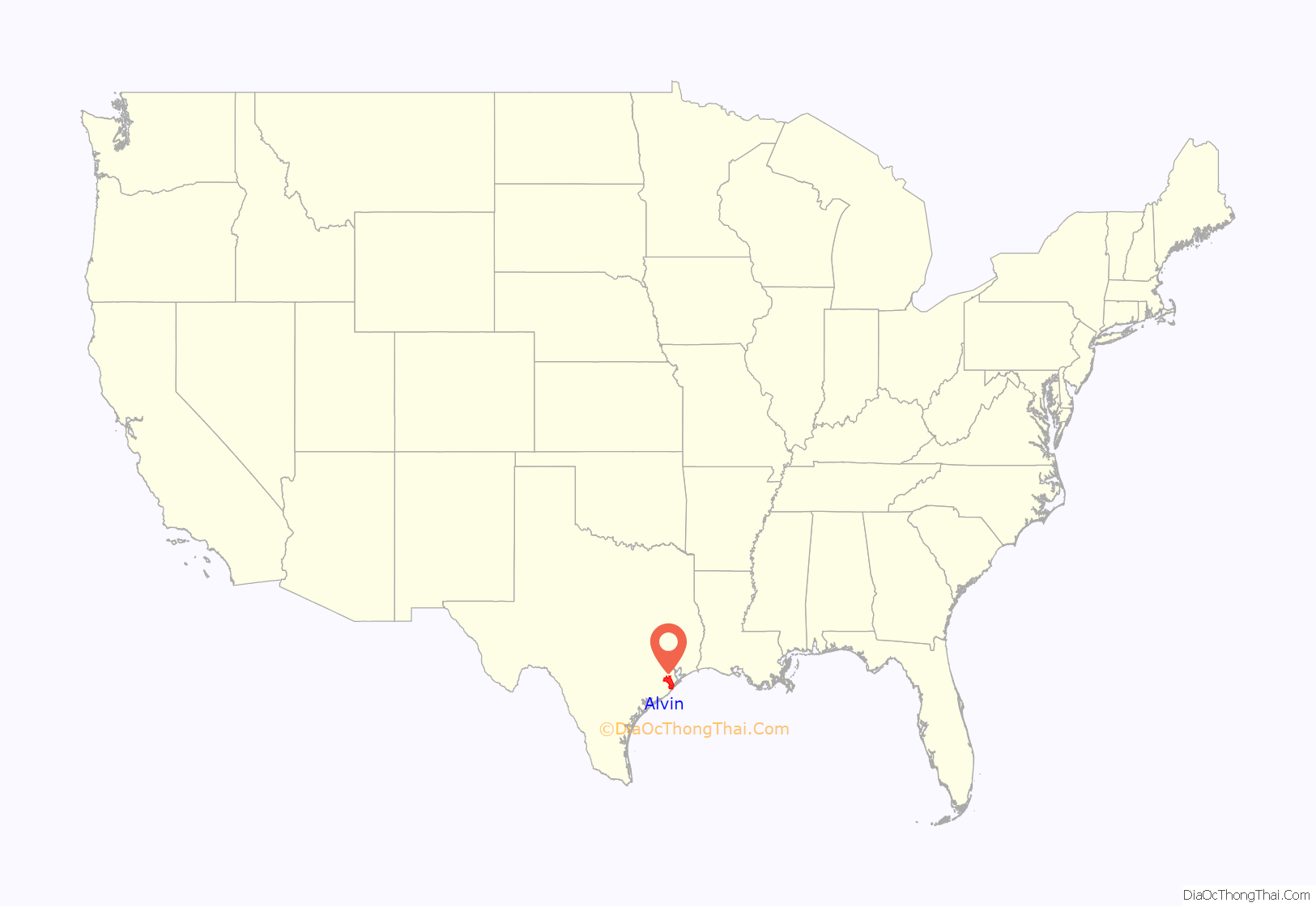
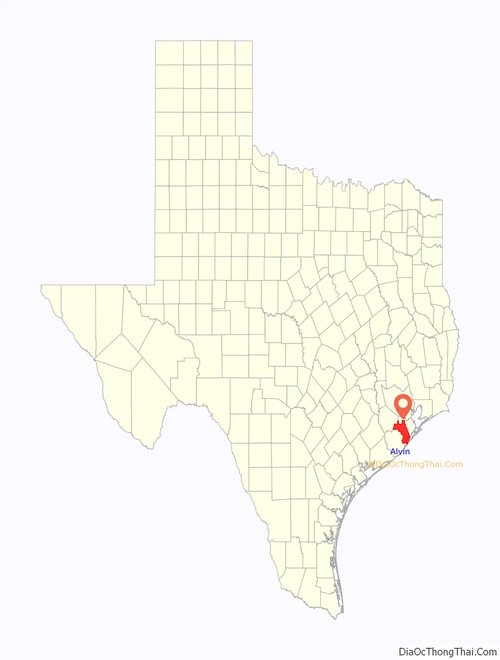
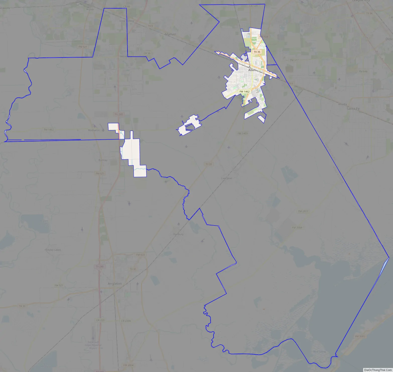
Alvin location map. Where is Alvin city?
History
The Alvin area was settled in the mid-19th century when bull ranches were established in the area. The Santa Fe Railroad eventually expanded into the area, and a settlement was established along the railroad. Alvin was originally named “Morgan” by the town’s residents in honor of the settlement’s original resident, Santa Fe employee Alvin Morgan; upon discovery that the name Morgan had been taken, the town named itself after Morgan’s first name. The town was officially incorporated in 1893, making it the oldest incorporated settlement in Brazoria County. Alvin Morgan received a land grant from the state of Texas prior to 1891.
Alvin was a sundown town, where practically no African Americans were allowed to live.
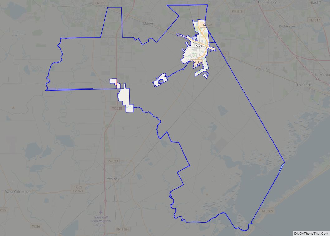
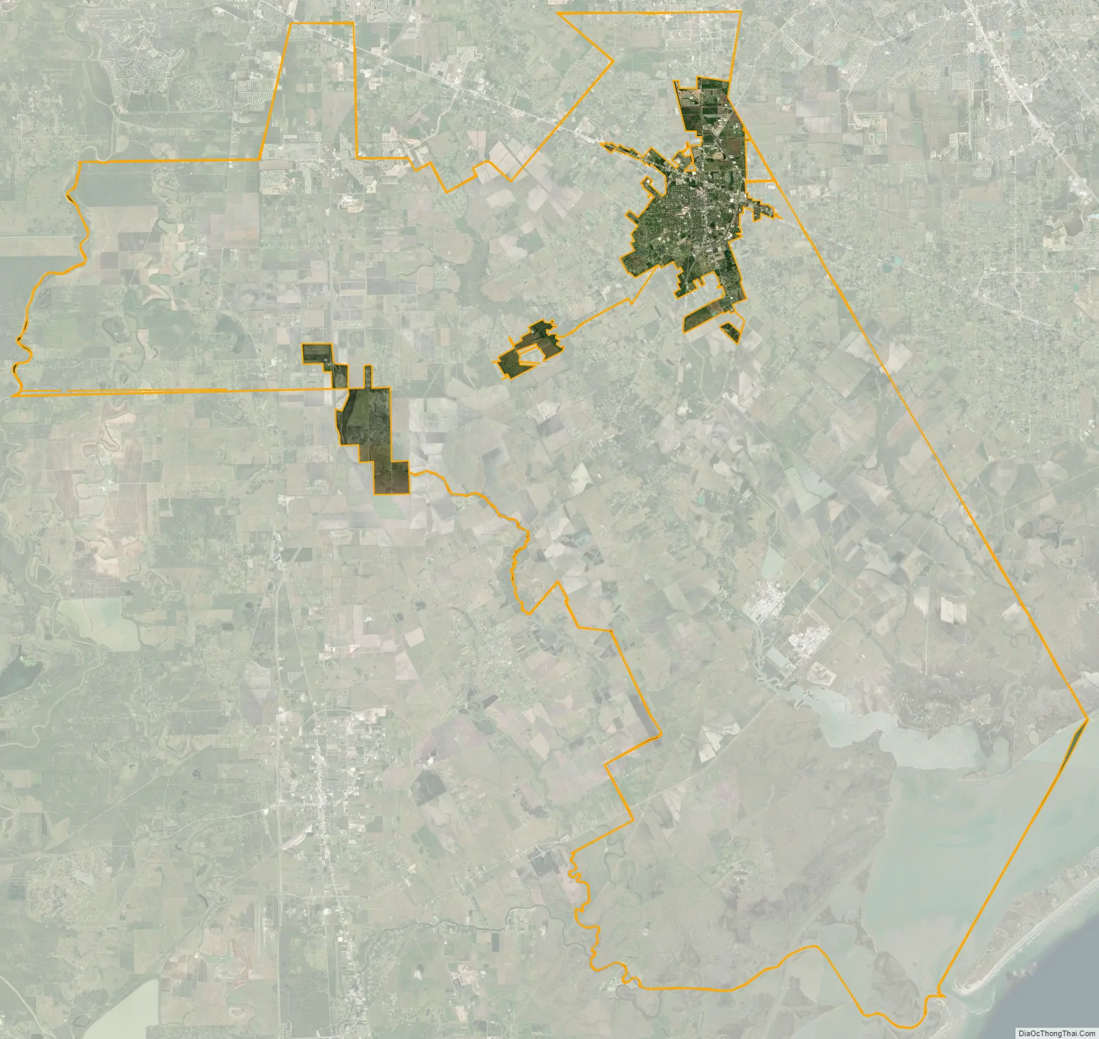
In 1960, the city annexed a 100-foot-wide (30 m) 137-mile-long (220 km) to protect Alvin from being annexed by other cities. The city’s unusual borders were the subject of a lawsuit against Missouri City when it attempted an annexation into Brazoria County and across Alvin’s city limits in 2002.
On July 25, 1979, Tropical Storm Claudette stalled over Alvin and inundated the region with 45 inches (1,140 mm) of rain in 42 hours. The total included 43 inches (1,090 mm) in 24 hours, at the time the highest amount of rainfall in 24 hours in American history.
Alvin Road Map
Alvin city Satellite Map
Geography
Alvin is located in northeastern Brazoria County at 29°23′37″N 95°16′18″W / 29.39361°N 95.27167°W / 29.39361; -95.27167 (29.393698, –95.271588). It is bordered to the northeast by Friendswood and League City in Galveston County, and part of its southeast border is along the village of Hillcrest. Texas State Highway 35 bypasses the center of the city to the east; it leads north 25 miles (40 km) to downtown Houston and southwest 21 miles (34 km) to Angleton, the Brazoria County seat. Texas State Highway 6 crosses Highway 35 and passes through the center of Alvin, leading southeast 30 miles (48 km) to Galveston and 28 miles (45 km) northwest to Sugar Land
According to the United States Census Bureau, Alvin has a total area of 25.6 square miles (66.4 km), of which 24.3 square miles (62.9 km) is land and 1.4 square miles (3.5 km), or 5.26%, is water.
See also
Map of Texas State and its subdivision:- Anderson
- Andrews
- Angelina
- Aransas
- Archer
- Armstrong
- Atascosa
- Austin
- Bailey
- Bandera
- Bastrop
- Baylor
- Bee
- Bell
- Bexar
- Blanco
- Borden
- Bosque
- Bowie
- Brazoria
- Brazos
- Brewster
- Briscoe
- Brooks
- Brown
- Burleson
- Burnet
- Caldwell
- Calhoun
- Callahan
- Cameron
- Camp
- Carson
- Cass
- Castro
- Chambers
- Cherokee
- Childress
- Clay
- Cochran
- Coke
- Coleman
- Collin
- Collingsworth
- Colorado
- Comal
- Comanche
- Concho
- Cooke
- Coryell
- Cottle
- Crane
- Crockett
- Crosby
- Culberson
- Dallam
- Dallas
- Dawson
- Deaf Smith
- Delta
- Denton
- Dewitt
- Dickens
- Dimmit
- Donley
- Duval
- Eastland
- Ector
- Edwards
- El Paso
- Ellis
- Erath
- Falls
- Fannin
- Fayette
- Fisher
- Floyd
- Foard
- Fort Bend
- Franklin
- Freestone
- Frio
- Gaines
- Galveston
- Garza
- Gillespie
- Glasscock
- Goliad
- Gonzales
- Gray
- Grayson
- Gregg
- Grimes
- Guadalupe
- Hale
- Hall
- Hamilton
- Hansford
- Hardeman
- Hardin
- Harris
- Harrison
- Hartley
- Haskell
- Hays
- Hemphill
- Henderson
- Hidalgo
- Hill
- Hockley
- Hood
- Hopkins
- Houston
- Howard
- Hudspeth
- Hunt
- Hutchinson
- Irion
- Jack
- Jackson
- Jasper
- Jeff Davis
- Jefferson
- Jim Hogg
- Jim Wells
- Johnson
- Jones
- Karnes
- Kaufman
- Kendall
- Kenedy
- Kent
- Kerr
- Kimble
- King
- Kinney
- Kleberg
- Knox
- La Salle
- Lamar
- Lamb
- Lampasas
- Lavaca
- Lee
- Leon
- Liberty
- Limestone
- Lipscomb
- Live Oak
- Llano
- Loving
- Lubbock
- Lynn
- Madison
- Marion
- Martin
- Mason
- Matagorda
- Maverick
- McCulloch
- McLennan
- McMullen
- Medina
- Menard
- Midland
- Milam
- Mills
- Mitchell
- Montague
- Montgomery
- Moore
- Morris
- Motley
- Nacogdoches
- Navarro
- Newton
- Nolan
- Nueces
- Ochiltree
- Oldham
- Orange
- Palo Pinto
- Panola
- Parker
- Parmer
- Pecos
- Polk
- Potter
- Presidio
- Rains
- Randall
- Reagan
- Real
- Red River
- Reeves
- Refugio
- Roberts
- Robertson
- Rockwall
- Runnels
- Rusk
- Sabine
- San Augustine
- San Jacinto
- San Patricio
- San Saba
- Schleicher
- Scurry
- Shackelford
- Shelby
- Sherman
- Smith
- Somervell
- Starr
- Stephens
- Sterling
- Stonewall
- Sutton
- Swisher
- Tarrant
- Taylor
- Terrell
- Terry
- Throckmorton
- Titus
- Tom Green
- Travis
- Trinity
- Tyler
- Upshur
- Upton
- Uvalde
- Val Verde
- Van Zandt
- Victoria
- Walker
- Waller
- Ward
- Washington
- Webb
- Wharton
- Wheeler
- Wichita
- Wilbarger
- Willacy
- Williamson
- Wilson
- Winkler
- Wise
- Wood
- Yoakum
- Young
- Zapata
- Zavala
- Alabama
- Alaska
- Arizona
- Arkansas
- California
- Colorado
- Connecticut
- Delaware
- District of Columbia
- Florida
- Georgia
- Hawaii
- Idaho
- Illinois
- Indiana
- Iowa
- Kansas
- Kentucky
- Louisiana
- Maine
- Maryland
- Massachusetts
- Michigan
- Minnesota
- Mississippi
- Missouri
- Montana
- Nebraska
- Nevada
- New Hampshire
- New Jersey
- New Mexico
- New York
- North Carolina
- North Dakota
- Ohio
- Oklahoma
- Oregon
- Pennsylvania
- Rhode Island
- South Carolina
- South Dakota
- Tennessee
- Texas
- Utah
- Vermont
- Virginia
- Washington
- West Virginia
- Wisconsin
- Wyoming