Sunnyvale is a town in Dallas County, Texas, United States. It is the easternmost city completely within Dallas County. The population was 7,893 in 2020. The affluent town had a median household income in 2020 of $137,656. [1][2] Within the last two decades the towns demographics drastically changed. The town once criticized for lack of diversity [3] now has a majority (50.67%) of its citizens POC, BIPOC, and AAPI members.
| Name: | Sunnyvale town |
|---|---|
| LSAD Code: | 43 |
| LSAD Description: | town (suffix) |
| State: | Texas |
| County: | Dallas County |
| Elevation: | 486 ft (148 m) |
| Total Area: | 16.79 sq mi (43.49 km²) |
| Land Area: | 16.52 sq mi (42.78 km²) |
| Water Area: | 0.27 sq mi (0.71 km²) |
| Total Population: | 7,893 |
| Population Density: | 414.1/sq mi (159.90/km²) |
| ZIP code: | 75182 |
| Area code: | 214, 469, 972 |
| FIPS code: | 4871156 |
| GNISfeature ID: | 1348079 |
| Website: | http://www.townofsunnyvale.org/ |
Online Interactive Map
Click on ![]() to view map in "full screen" mode.
to view map in "full screen" mode.
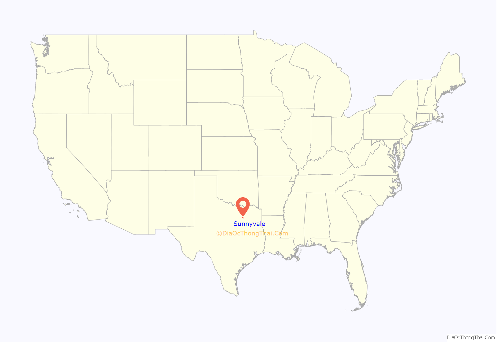
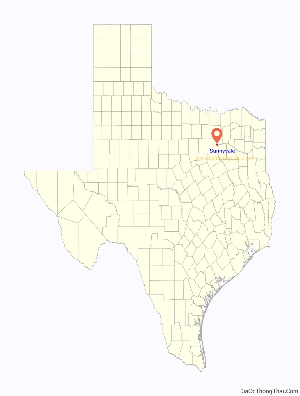
Sunnyvale location map. Where is Sunnyvale town?
History
The area now occupied by Sunnyvale was inhabited by various Native American tribes in the years before the European conquest of the Americas. It came under the rule of Spain in the 18th century, very close to the boundary of Spanish and French territory (although this boundary was carried upward a bit in 1819; see Adams-Onís Treaty). During this time, the area was relatively underdeveloped. However, some settlers migrated to Texas and would eventually settle in Sunnyvale.
In 1821, the area became a possession of Mexico when Mexico received its independence from Spain. After the Texas Revolution, the area once again changed hands, under the Republic of Texas. This is when the town started to develop. During this time, settlers migrated to present-day Sunnyvale, naming the hamlet they founded Long Creek. In 1845 Texas became a U.S. state.
As more people arrived, eventually three new hamlets sprang up in the area: New Hope, Tripp, and Hatterville. New Hope was the most prosperous of these. It had many shops and stores, a fair called Gala Days, and a newspaper, the New Hope News. It was neighboring Mesquite’s biggest rival. This all ended in 1921, when a storm blew the town away. Many buildings were damaged and the prosperous days were over. From this year on to the 1950s, the four towns had no new developments, remaining stagnant.
In the year 1953, the hamlets of Hatterville, New Hope, Long Creek, and Tripp merged under the name Sunnyvale. The name was chosen in a contest from a local school. Since, there are many reminders of Sunnyvale’s rich history, like the old New Hope School; the Tripp First Baptist Church, built in 1882; and many antique houses. The Long Creek Cemetery in southern Sunnyvale is over 150 years old, and the first recorded burial there is that of Leona Crownover Caldwell, dated October 2, 1855.
In March 2012, Sunnyvale, Texas was named the whitest town in North Texas by D Magazine. The reason that Sunnyvale was named the whitest town in North Texas was based on an initial, U.S. District Judge Jerry Buchmeyern study that deducted that out of 2,228 residents in Sunnyvale, that only 16 of them were Black American or African American.
On December 26, 2015, the town was struck by an EF-4 tornado causing extensive damage to the Plantation RV park, the tornado then grew and moved northeast into Garland and Rowlett killing 12 people and injuring many.
On March 31st, 2023 Sunnyvale Texas was put on a shelter in place ordinance. [4] After a suspect led a miles long driving excursion from the police spanning three counties. It led to the assailant leaving his car armed and whereabouts unknown for numerous hours within the town. [5] Sunnyvale Police came under scrutiny for their delayed efforts and time to find the suspect. [6]
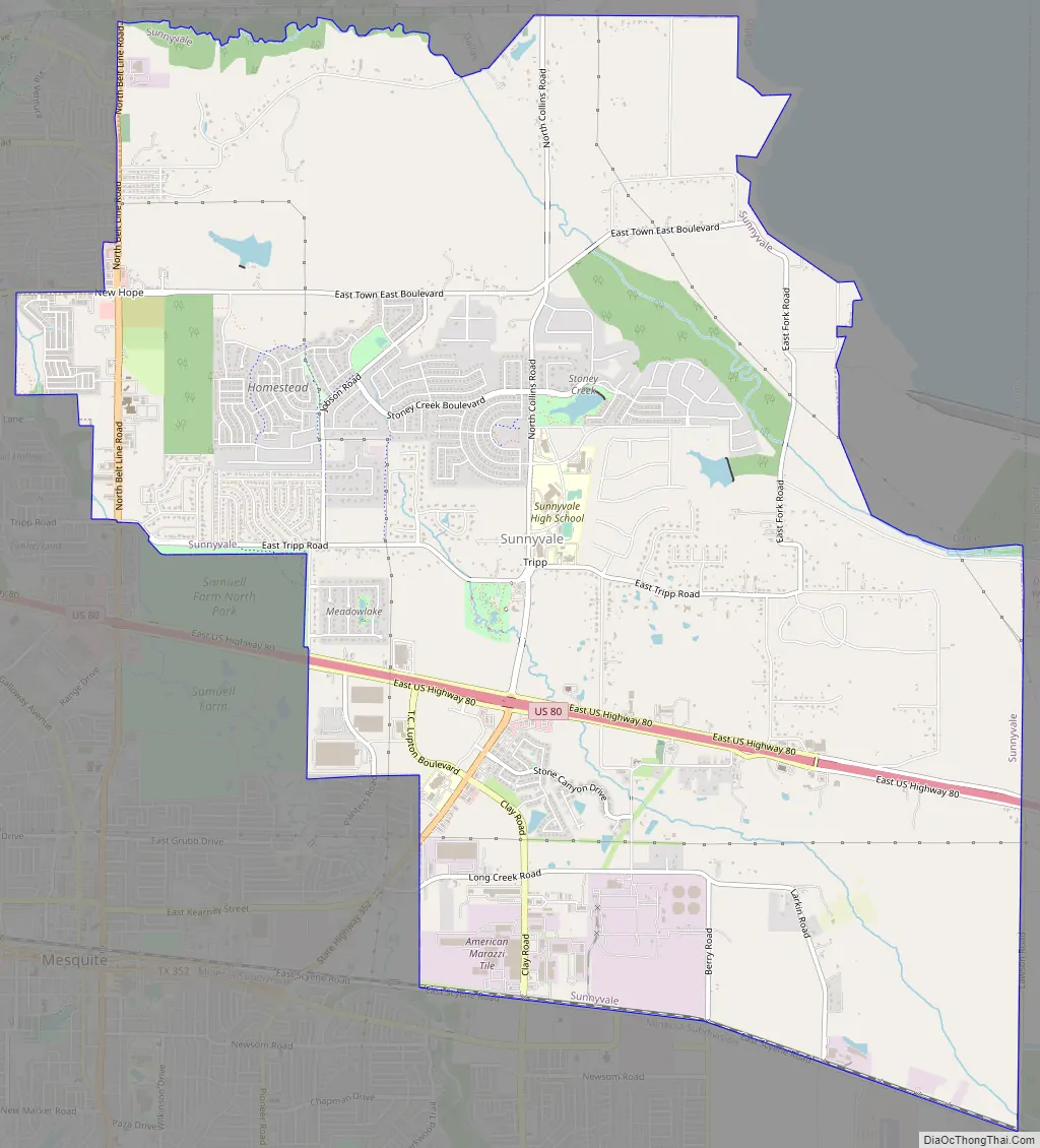
Sunnyvale Road Map
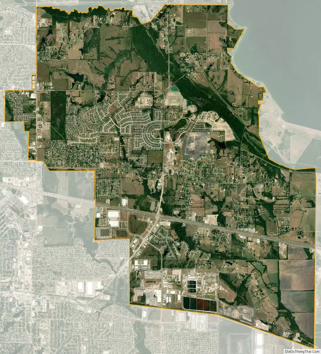
Sunnyvale city Satellite Map
Geography
Sunnyvale is located at 32°48′13″N 96°34′11″W / 32.80361°N 96.56972°W / 32.80361; -96.56972 (32.803646, –96.569654). According to the United States Census Bureau, the town has a total area of 16.8 square miles (44 km), all of it land.
See also
Map of Texas State and its subdivision:- Anderson
- Andrews
- Angelina
- Aransas
- Archer
- Armstrong
- Atascosa
- Austin
- Bailey
- Bandera
- Bastrop
- Baylor
- Bee
- Bell
- Bexar
- Blanco
- Borden
- Bosque
- Bowie
- Brazoria
- Brazos
- Brewster
- Briscoe
- Brooks
- Brown
- Burleson
- Burnet
- Caldwell
- Calhoun
- Callahan
- Cameron
- Camp
- Carson
- Cass
- Castro
- Chambers
- Cherokee
- Childress
- Clay
- Cochran
- Coke
- Coleman
- Collin
- Collingsworth
- Colorado
- Comal
- Comanche
- Concho
- Cooke
- Coryell
- Cottle
- Crane
- Crockett
- Crosby
- Culberson
- Dallam
- Dallas
- Dawson
- Deaf Smith
- Delta
- Denton
- Dewitt
- Dickens
- Dimmit
- Donley
- Duval
- Eastland
- Ector
- Edwards
- El Paso
- Ellis
- Erath
- Falls
- Fannin
- Fayette
- Fisher
- Floyd
- Foard
- Fort Bend
- Franklin
- Freestone
- Frio
- Gaines
- Galveston
- Garza
- Gillespie
- Glasscock
- Goliad
- Gonzales
- Gray
- Grayson
- Gregg
- Grimes
- Guadalupe
- Hale
- Hall
- Hamilton
- Hansford
- Hardeman
- Hardin
- Harris
- Harrison
- Hartley
- Haskell
- Hays
- Hemphill
- Henderson
- Hidalgo
- Hill
- Hockley
- Hood
- Hopkins
- Houston
- Howard
- Hudspeth
- Hunt
- Hutchinson
- Irion
- Jack
- Jackson
- Jasper
- Jeff Davis
- Jefferson
- Jim Hogg
- Jim Wells
- Johnson
- Jones
- Karnes
- Kaufman
- Kendall
- Kenedy
- Kent
- Kerr
- Kimble
- King
- Kinney
- Kleberg
- Knox
- La Salle
- Lamar
- Lamb
- Lampasas
- Lavaca
- Lee
- Leon
- Liberty
- Limestone
- Lipscomb
- Live Oak
- Llano
- Loving
- Lubbock
- Lynn
- Madison
- Marion
- Martin
- Mason
- Matagorda
- Maverick
- McCulloch
- McLennan
- McMullen
- Medina
- Menard
- Midland
- Milam
- Mills
- Mitchell
- Montague
- Montgomery
- Moore
- Morris
- Motley
- Nacogdoches
- Navarro
- Newton
- Nolan
- Nueces
- Ochiltree
- Oldham
- Orange
- Palo Pinto
- Panola
- Parker
- Parmer
- Pecos
- Polk
- Potter
- Presidio
- Rains
- Randall
- Reagan
- Real
- Red River
- Reeves
- Refugio
- Roberts
- Robertson
- Rockwall
- Runnels
- Rusk
- Sabine
- San Augustine
- San Jacinto
- San Patricio
- San Saba
- Schleicher
- Scurry
- Shackelford
- Shelby
- Sherman
- Smith
- Somervell
- Starr
- Stephens
- Sterling
- Stonewall
- Sutton
- Swisher
- Tarrant
- Taylor
- Terrell
- Terry
- Throckmorton
- Titus
- Tom Green
- Travis
- Trinity
- Tyler
- Upshur
- Upton
- Uvalde
- Val Verde
- Van Zandt
- Victoria
- Walker
- Waller
- Ward
- Washington
- Webb
- Wharton
- Wheeler
- Wichita
- Wilbarger
- Willacy
- Williamson
- Wilson
- Winkler
- Wise
- Wood
- Yoakum
- Young
- Zapata
- Zavala
- Alabama
- Alaska
- Arizona
- Arkansas
- California
- Colorado
- Connecticut
- Delaware
- District of Columbia
- Florida
- Georgia
- Hawaii
- Idaho
- Illinois
- Indiana
- Iowa
- Kansas
- Kentucky
- Louisiana
- Maine
- Maryland
- Massachusetts
- Michigan
- Minnesota
- Mississippi
- Missouri
- Montana
- Nebraska
- Nevada
- New Hampshire
- New Jersey
- New Mexico
- New York
- North Carolina
- North Dakota
- Ohio
- Oklahoma
- Oregon
- Pennsylvania
- Rhode Island
- South Carolina
- South Dakota
- Tennessee
- Texas
- Utah
- Vermont
- Virginia
- Washington
- West Virginia
- Wisconsin
- Wyoming