Wilmer is a city in Dallas County, Texas, United States. The population was 3,682 at the 2010 census. It is part of the Dallas–Fort Worth–Arlington Metropolitan Statistical Area.
| Name: | Wilmer city |
|---|---|
| LSAD Code: | 25 |
| LSAD Description: | city (suffix) |
| State: | Texas |
| County: | Dallas County |
| Elevation: | 466 ft (142 m) |
| Total Area: | 6.40 sq mi (16.57 km²) |
| Land Area: | 6.34 sq mi (16.43 km²) |
| Water Area: | 0.05 sq mi (0.14 km²) |
| Total Population: | 3,682 |
| Population Density: | 752.09/sq mi (290.37/km²) |
| ZIP code: | 75172 |
| Area code: | 972 |
| FIPS code: | 4879576 |
| GNISfeature ID: | 1350245 |
| Website: | http://www.cityofwilmer.net/ |
Online Interactive Map
Click on ![]() to view map in "full screen" mode.
to view map in "full screen" mode.
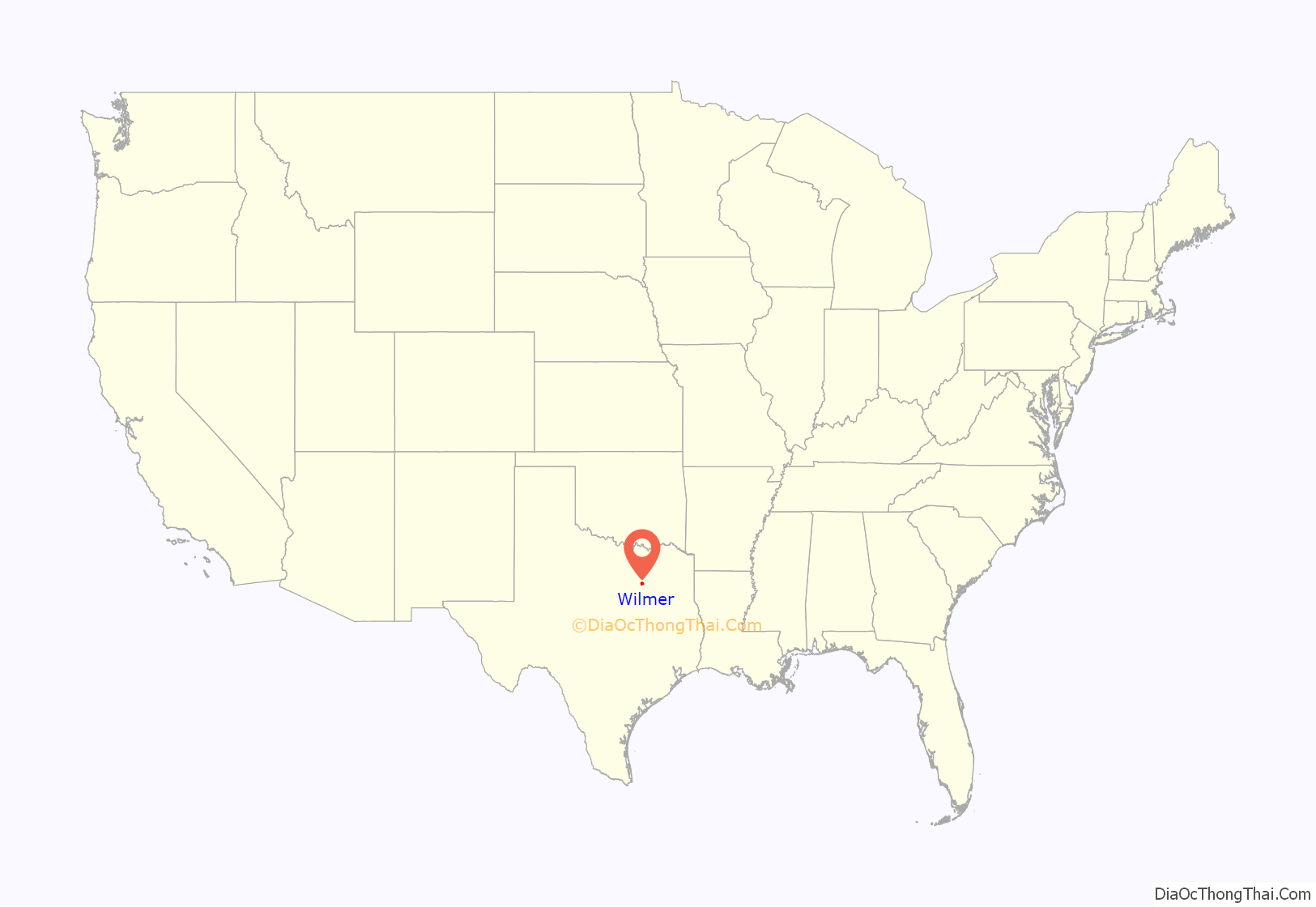
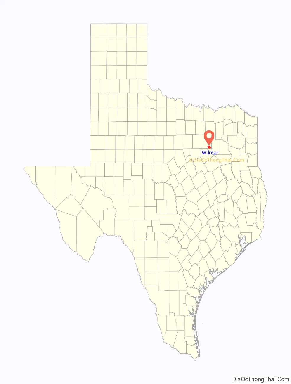
Wilmer location map. Where is Wilmer city?
History
The area was initially settled by Andrew K. Gray before 1850. The settlement was originally known as Prairie Valley when the Houston and Texas Central Railroad arrived in 1872. In 1884, the post office in Prairie Valley was renamed Wilmer, after A.J. Wilmer, a conductor on the Houston and Texas Central line. The population was estimated at 100 in 1890, with several stores and businesses operation in the community. That figure had risen to over 200 by the start of World War I. A fire destroyed most of Wilmer’s business district on July 4, 1929. The community’s shallow wells were unable to pump the adequate amount of water needed to extinguish the blaze.
Wilmer incorporated in 1945, and its first mayor, J.H. May, was elected on a platform of installing a water system. At the time of incorporation, Wilmer had 136 homes and a population of approximately 450. In 1949, a volunteer fire department was established and a fire truck was purchased. Around the same time, Wilmer and the neighboring city of Hutchins consolidated their schools. By 1960, Wilmer was home to 1,785 residents. Throughout the latter half of the twentieth century, Wilmer continued to grow, but at a much slower rate than other communities in Dallas County. With 3,393 residents as of the 2000 census, Wilmer is currently one of the smallest incorporated cities in Dallas County.
Wilmer Road Map
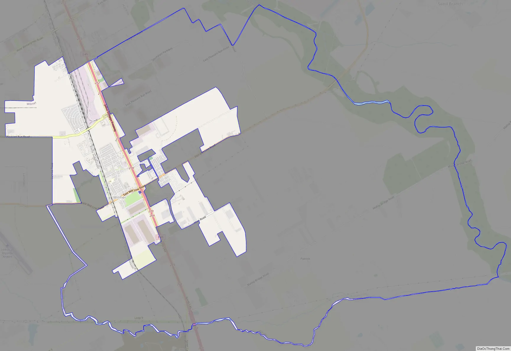
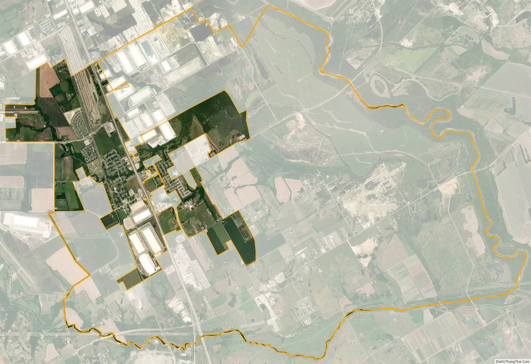
Wilmer city Satellite Map
Geography
Wilmer is located at 32°35′27″N 96°40′57″W / 32.59083°N 96.68250°W / 32.59083; -96.68250 (32.590743, –96.682619). It is situated along Interstate 45 in southeastern Dallas County, approximately 14 miles (23 km) south of downtown Dallas.
According to the United States Census Bureau, the city has a total area of 6.4 square miles (16.7 km), of which 6.4 square miles (16.5 km) is land and 0.04 square miles (0.1 km), or 0.82%, is water.
See also
Map of Texas State and its subdivision:- Anderson
- Andrews
- Angelina
- Aransas
- Archer
- Armstrong
- Atascosa
- Austin
- Bailey
- Bandera
- Bastrop
- Baylor
- Bee
- Bell
- Bexar
- Blanco
- Borden
- Bosque
- Bowie
- Brazoria
- Brazos
- Brewster
- Briscoe
- Brooks
- Brown
- Burleson
- Burnet
- Caldwell
- Calhoun
- Callahan
- Cameron
- Camp
- Carson
- Cass
- Castro
- Chambers
- Cherokee
- Childress
- Clay
- Cochran
- Coke
- Coleman
- Collin
- Collingsworth
- Colorado
- Comal
- Comanche
- Concho
- Cooke
- Coryell
- Cottle
- Crane
- Crockett
- Crosby
- Culberson
- Dallam
- Dallas
- Dawson
- Deaf Smith
- Delta
- Denton
- Dewitt
- Dickens
- Dimmit
- Donley
- Duval
- Eastland
- Ector
- Edwards
- El Paso
- Ellis
- Erath
- Falls
- Fannin
- Fayette
- Fisher
- Floyd
- Foard
- Fort Bend
- Franklin
- Freestone
- Frio
- Gaines
- Galveston
- Garza
- Gillespie
- Glasscock
- Goliad
- Gonzales
- Gray
- Grayson
- Gregg
- Grimes
- Guadalupe
- Hale
- Hall
- Hamilton
- Hansford
- Hardeman
- Hardin
- Harris
- Harrison
- Hartley
- Haskell
- Hays
- Hemphill
- Henderson
- Hidalgo
- Hill
- Hockley
- Hood
- Hopkins
- Houston
- Howard
- Hudspeth
- Hunt
- Hutchinson
- Irion
- Jack
- Jackson
- Jasper
- Jeff Davis
- Jefferson
- Jim Hogg
- Jim Wells
- Johnson
- Jones
- Karnes
- Kaufman
- Kendall
- Kenedy
- Kent
- Kerr
- Kimble
- King
- Kinney
- Kleberg
- Knox
- La Salle
- Lamar
- Lamb
- Lampasas
- Lavaca
- Lee
- Leon
- Liberty
- Limestone
- Lipscomb
- Live Oak
- Llano
- Loving
- Lubbock
- Lynn
- Madison
- Marion
- Martin
- Mason
- Matagorda
- Maverick
- McCulloch
- McLennan
- McMullen
- Medina
- Menard
- Midland
- Milam
- Mills
- Mitchell
- Montague
- Montgomery
- Moore
- Morris
- Motley
- Nacogdoches
- Navarro
- Newton
- Nolan
- Nueces
- Ochiltree
- Oldham
- Orange
- Palo Pinto
- Panola
- Parker
- Parmer
- Pecos
- Polk
- Potter
- Presidio
- Rains
- Randall
- Reagan
- Real
- Red River
- Reeves
- Refugio
- Roberts
- Robertson
- Rockwall
- Runnels
- Rusk
- Sabine
- San Augustine
- San Jacinto
- San Patricio
- San Saba
- Schleicher
- Scurry
- Shackelford
- Shelby
- Sherman
- Smith
- Somervell
- Starr
- Stephens
- Sterling
- Stonewall
- Sutton
- Swisher
- Tarrant
- Taylor
- Terrell
- Terry
- Throckmorton
- Titus
- Tom Green
- Travis
- Trinity
- Tyler
- Upshur
- Upton
- Uvalde
- Val Verde
- Van Zandt
- Victoria
- Walker
- Waller
- Ward
- Washington
- Webb
- Wharton
- Wheeler
- Wichita
- Wilbarger
- Willacy
- Williamson
- Wilson
- Winkler
- Wise
- Wood
- Yoakum
- Young
- Zapata
- Zavala
- Alabama
- Alaska
- Arizona
- Arkansas
- California
- Colorado
- Connecticut
- Delaware
- District of Columbia
- Florida
- Georgia
- Hawaii
- Idaho
- Illinois
- Indiana
- Iowa
- Kansas
- Kentucky
- Louisiana
- Maine
- Maryland
- Massachusetts
- Michigan
- Minnesota
- Mississippi
- Missouri
- Montana
- Nebraska
- Nevada
- New Hampshire
- New Jersey
- New Mexico
- New York
- North Carolina
- North Dakota
- Ohio
- Oklahoma
- Oregon
- Pennsylvania
- Rhode Island
- South Carolina
- South Dakota
- Tennessee
- Texas
- Utah
- Vermont
- Virginia
- Washington
- West Virginia
- Wisconsin
- Wyoming