Lancaster (/ˈlæŋkɪstər/ LANK-is-tər) is a city in Dallas County, Texas, United States. Its population was 41,275 according to the 2020 census. Founded in 1852 as a frontier post, Lancaster is one of Dallas County’s earliest settlements. Today, it is a suburban community located in the Dallas–Fort Worth metroplex, about 15 mi (24 km) south of downtown Dallas.
Lancaster is part of the Best Southwest area, which includes Lancaster, Cedar Hill, DeSoto, and Duncanville.
| Name: | Lancaster city |
|---|---|
| LSAD Code: | 25 |
| LSAD Description: | city (suffix) |
| State: | Texas |
| County: | Dallas County |
| Elevation: | 522 ft (159 m) |
| Total Area: | 33.11 sq mi (85.77 km²) |
| Land Area: | 33.06 sq mi (85.63 km²) |
| Water Area: | 0.05 sq mi (0.14 km²) |
| Total Population: | 41,275 |
| Population Density: | 1,186.50/sq mi (458.10/km²) |
| Area code: | 214, 469, 972 |
| FIPS code: | 4841212 |
| GNISfeature ID: | 1339599 |
| Website: | Lancaster-TX.com |
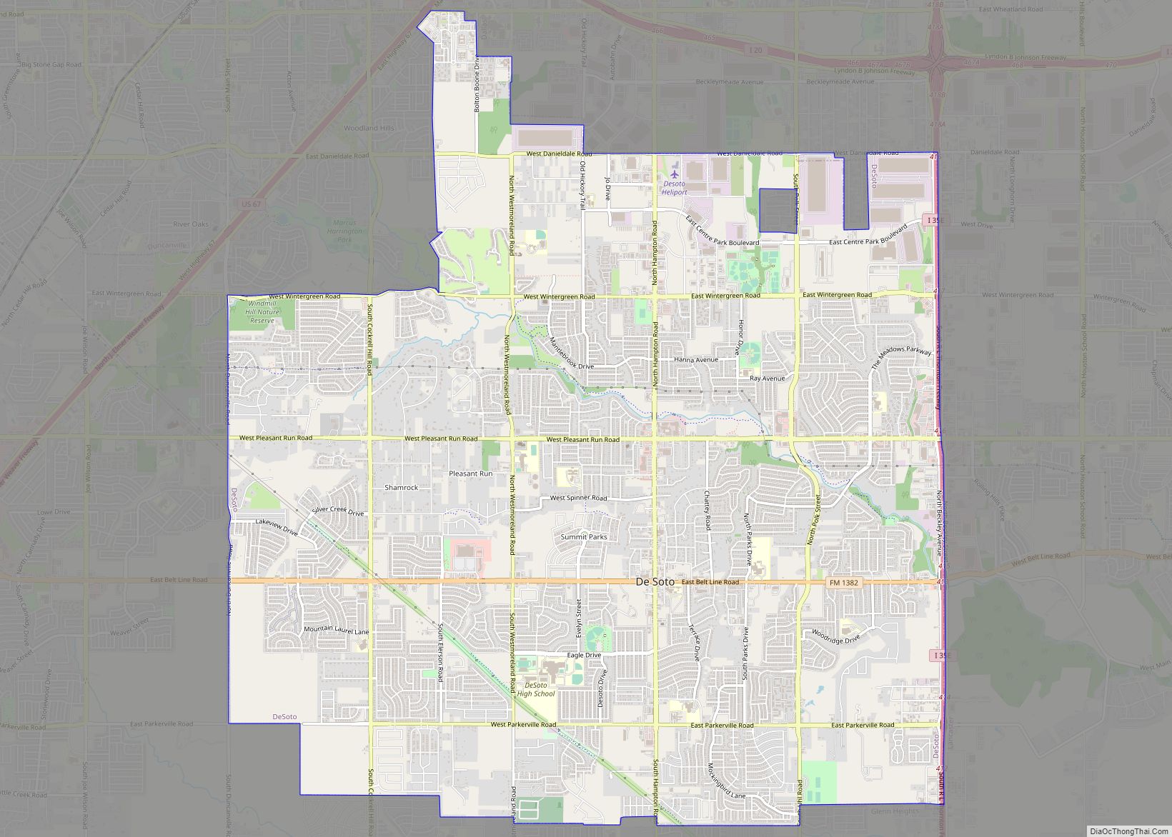
Online Interactive Map
Click on ![]() to view map in "full screen" mode.
to view map in "full screen" mode.
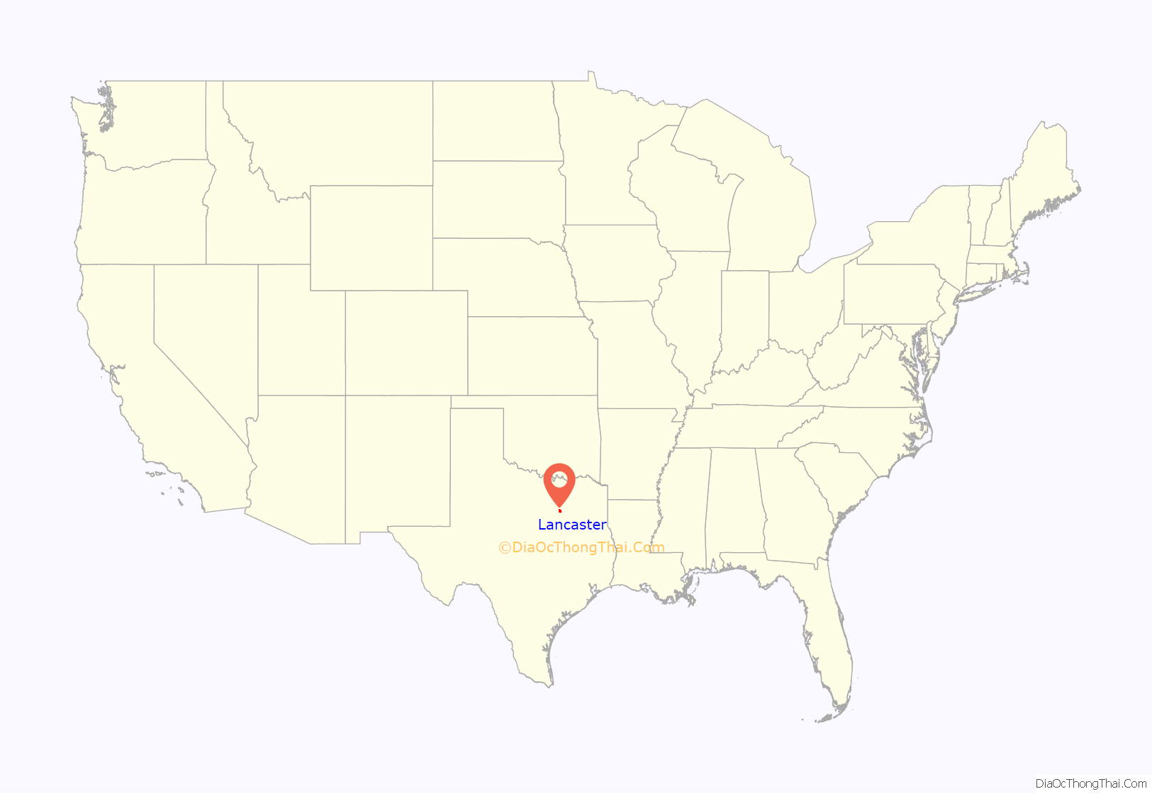
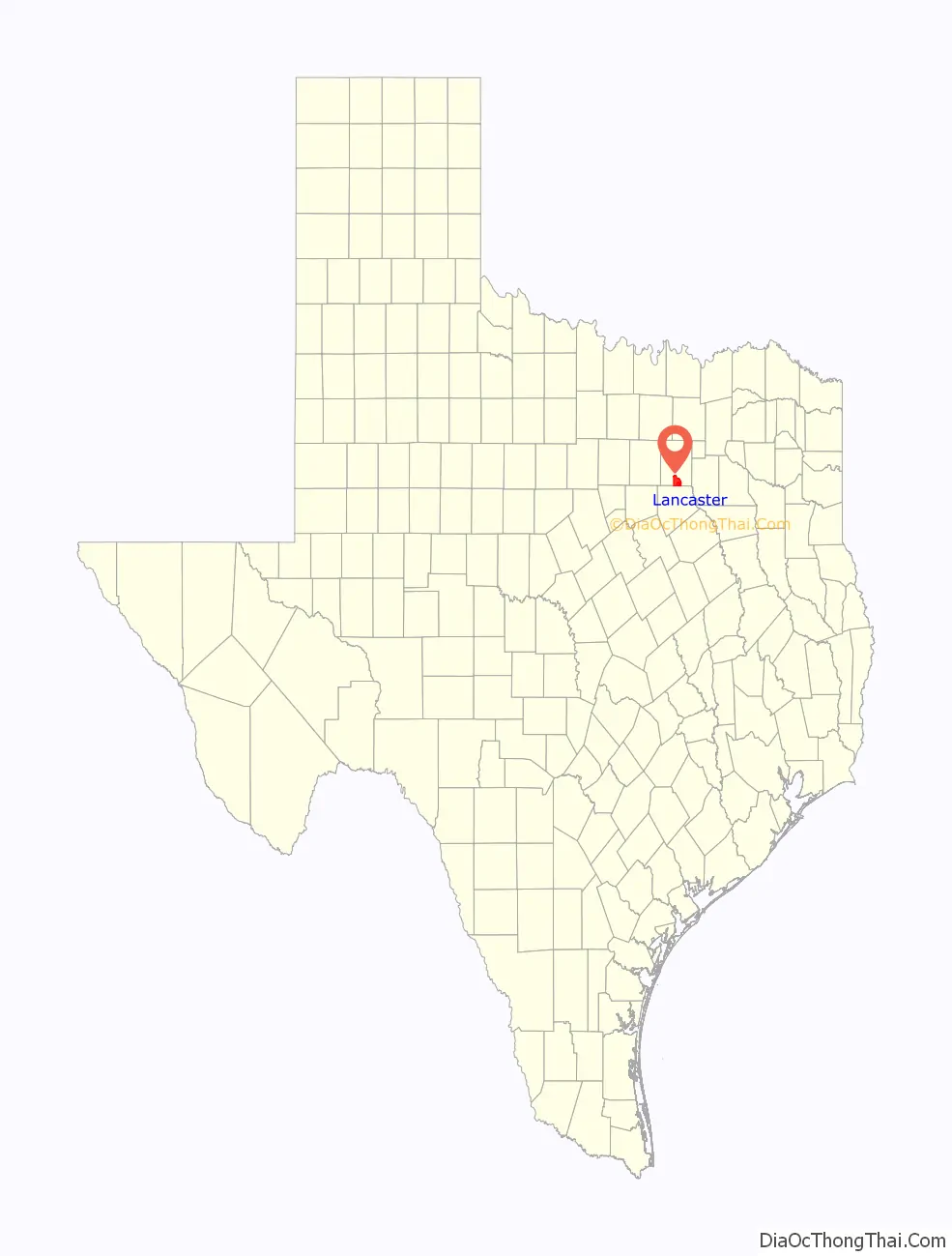
Lancaster location map. Where is Lancaster city?
History
Early settlement
In 1841, an act of the Republic of Texas Congress authorized President Mirabeau Lamar to enter into a contract with William S. Peters and 19 associates to promote settlement in North Texas, and paid the company with free land in exchange for recruiting new settlers. Around 600 families settled in what became known as Peters Colony from 1841 through 1844. The Peters’ group advertised heavily in Kentucky, Illinois, Missouri, and Tennessee, so many of the earliest settlers were from those states. The first group to settle in the Lancaster area was Roderick Rawlins and his family from Greene County, Illinois. They left for Texas in September 1844. Rawlins and two of his sons-in-law came ahead to select the general area where they would settle. They chose an uninhabited area south of Dallas along the north bank of Ten Mile Creek as the site of their new settlement. In December 1844, the three men went back to Lamar County near the Red River to bring the rest of their wagon train. All of the settlers had arrived by January 2, 1845, and they formed a community known as Hardscrabble. It consisted of two rows of log cabins with a street running north and south. In total, 30 men, women, and children lived in Hardscrabble.
Several miles north of Hardscrabble, a second community called Pleasant Run was established in 1846 by Polly Rawlins, one of Roderick’s daughters, and her husband Madison Moultrie “M.M.” Miller. Together, the Millers built a two-room structure, with one room used as a general store and the other for living. By 1848, the structure had grown to 15 rooms, a separate store, and a warehouse. A post office was established with biweekly mail delivery and Miller as postmaster. By 1850, he had laid out a town and sold lots, but never filed a plat of the community with Dallas County. At its peak, Pleasant Run boasted a stage stop, school, and steam-powered grist mill in addition to Miller’s store. Accelerated by the death of M.M. Miller in 1860, Pleasant Run declined. Shortly after the Rawlins’ settlers abandoned the Hardscrabble settlement, Lancaster became the dominant community in the area.
Founding of Lancaster
The founder of Lancaster was “A” Bledsoe (Some sources list his name as Abram Bledsoe. or Albert A. Bledsoe). He was born in Lancaster, Kentucky, in 1801. According to family lore, when his father Moses first looked at his newborn son, he is said to have remarked, “he looks like a Bledsoe.” Thus his name, A Bledsoe, is unmarked by a period.
Bledsoe surveyed and staked off the original town of Lancaster in 1852. He purchased 430 acres of land from the widow of Roderick Rawlins, and modeled it after his Kentucky hometown. The layout featured a town square with streets entering from the center of each side rather than from the corners. Bledsoe began selling lots at a public auction in 1853, reportedly giving as many as two-thirds of them to settlers from the nearby Pleasant Run community. The official plat of the town of Lancaster was not filed with Dallas County until 1857. Bledsoe later served as Dallas County judge and state comptroller. He died in 1882.
In 1860, a post office was established in Lancaster.
Progress and challenges
During the American Civil War, the Tucker, Sherrod &and Company contracted with the State of Texas to manufacture replicas of the .44 caliber Colt Dragoon from a factory on West Main Street in Lancaster. John M. Crockett, former mayor of Dallas and lieutenant governor of Texas, served as superintendent of the arms factory. In the early years of Reconstruction, a drought crippled the economy to such an extent that few residents could afford more than the most basic of necessities. The economy did not fully recover until well into the 1870s, due in large part to the town’s proximity to heavily trafficked cattle trails. The first public well was dug in the city’s town square in 1876. Fires destroyed parts of the square in 1877, 1889, and again in 1918, each time being promptly rebuilt. Local telephone service came to Lancaster in 1881. Lancaster was incorporated on May 5, 1886. One year later, the Lancaster Herald newspaper began printing.
In December 1888, Lancaster’s train depot opened as a stop on the Dallas and Waco Railway. In 1891, it became part of the Missouri–Kansas–Texas Railroad (MKT) line, running from Dallas to the Gulf Coast of Texas. The Lancaster Tap Railroad, completed in 1890, connected the MKT line in Lancaster with the Dallas-Houston line of the Houston and Texas Central Railway (H&TC) in Hutchins, 4.5 miles away. It operated for 44 years. Rene Paul “R.P.” Henry opened the first official bank in 1889. By 1897, the town had a public school, Masonic Temple, a chapter of the International Order of Odd Fellows, and a variety of Christian churches. From 1898 to 1901, Texas Christian University founder Randolph Clark established Randolph College in Lancaster. After its closure, the facilities were used continuously until they burned in a 1912 fire.
Early 20th century
At the start of the 20th century, Lancaster had 1,045 residents and served hundreds more from the surrounding rural areas who worked, worshiped, attended school, and made their purchases in the town. The Texas Legislature created the Lancaster Independent School District in March 1905, and voters approved several bond elections over the next decade that improved educational facilities. Electric lighting was introduced in 1911 via the Texas Power and Light Company, when the interurban Texas Electric Railway (Dallas to Waco) ran through town. Lancaster remained tied to its surrounding agricultural lands. Farmers produced a wide range of crops, including wheat, cotton, beans, peas, and sweet potatoes. Many agricultural-related businesses also thrived until the Dust Bowl and Great Depression caused the economy to contract. On February 27, 1934, Clyde Barrow of Bonnie & Clyde fame robbed the R.P. Henry and Sons Bank that was then located near the southeast corner of the town square. Bonnie Parker waited in the getaway car on Malloy Bridge Road while Clyde and Raymond Hamilton walked in, robbed the bank, and walked out with over $4,000. In June 1936, a storm toppled Lancaster’s 50,000-gallon water tower, brought down utility poles, and damaged many homes. In the early 1940s, the economic climate began to show improvement.
Suburbanization
Between 1900 and 1940, Lancaster’s population grew slowly, ranging between 1,000 and 1,200 at each census. In 1950, the population had risen to just over 2,600. Soon after, the growth rate rapidly increased as Lancaster began to transform from a small town into a suburban bedroom community of Dallas. By 1960, 7,501 residents were living in the city, a 185% increase over the 1950 figure. Highlights of the 1970s included a 1975 urban renewal project to improve the town square, which had suffered a loss of businesses to areas outside of downtown, and the opening of Cedar Valley College in 1977. Significant development continued into the 1980s. A hospital, two shopping centers, four schools, several apartment complexes, and a number of new residential subdivisions were built to accommodate the growing population.
Recent history
On the night of April 25, 1994, a violent F4 tornado ripped through Lancaster, killing three and injuring nearly 50 others. More than 250 homes and every building on the town square were heavily damaged or completely destroyed by the roughly half-mile-wide tornado. The White and Company Bank building, a local landmark since 1898, was severely damaged in the tornado, but was rebuilt, and in 1998, reopened as headquarters for the Lancaster Economic Development Corporation.
In 2005 and 2006, Lancaster was a finalist for the All-America City Award. In 2007 the National Arbor Day Foundation designated Lancaster a Tree City USA.
Between 2000 and 2010, Lancaster’s population increased by 40%, making it one of the fastest-growing cities in Dallas County during the decade.
On April 3, 2012, an EF-2 tornado struck the city as part of the tornado outbreak; 300 structures were reported damaged. A tornado emergency was not called for Lancaster, but a tornado emergency was called for the nearby cities of Dallas, Greenville, and Arlington. No deaths were reported from either the Lancaster tornado or any other tornado that day.
On June 23, 2019, Lancaster was one of 10 U.S. communities selected to receive the All-America City Award from the National Civic League. The city was recognized for its civic engagement and communications to address community health concerns through: the development of new and improvement of existing parks; a community health challenge with runs, walks and health fairs; and a workplace wellness program.
Lancaster Road Map

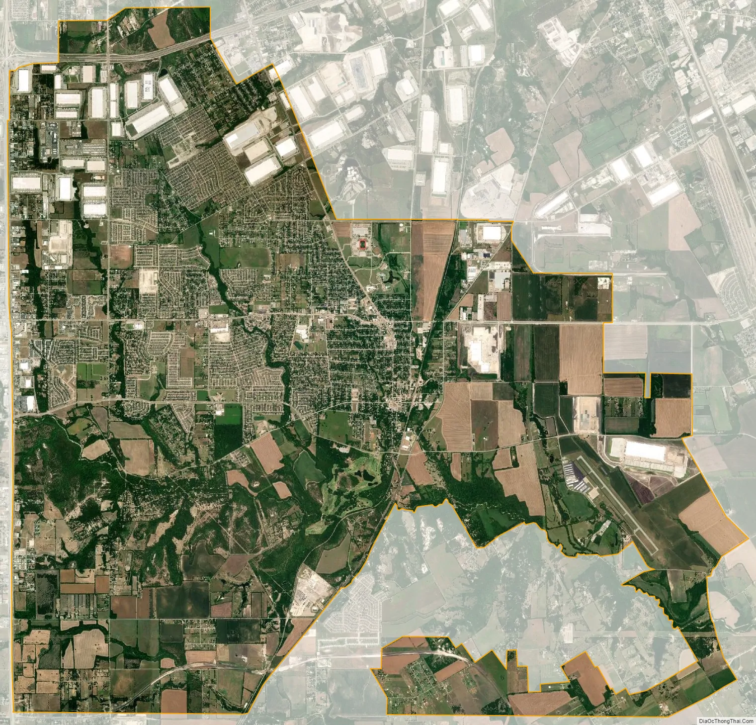
Lancaster city Satellite Map
Geography
Lancaster is located in southern Dallas County and is part of the Dallas–Fort Worth metroplex, the largest metropolitan area in Texas. According to the United States Census Bureau, the city has a total area of 30.35 sq mi (78.6 km), of which 30.28 sq mi (78.4 km) are land and 0.07 sq mi (0.18 km) is covered by water. On November 14, 2011, a tract of land covering 2.9 sq mi (7.5 km) within Lancaster’s extraterritorial jurisdiction (ETJ) was annexed to the city.
Lancaster is situated within the Blackland Prairie region of Texas, which is characterized by level to gently rolling topography. Ten Mile Creek and its tributaries are major drainage features in and around the city. Because the area was used for farming and other agricultural businesses, much of the natural vegetation has been cleared. Areas near creeks have retained some of their original tree cover, which includes pecan trees, cedar elms, and several species of oaks.
Climate
Lancaster is located within the humid subtropical climate zone (Köppen climate classification: Cfa), which is characterized by hot, humid summers and mild to cool winters. Typically, July is the warmest month and January is the coolest month. The maximum average precipitation occurs in May.
See also
Map of Texas State and its subdivision:- Anderson
- Andrews
- Angelina
- Aransas
- Archer
- Armstrong
- Atascosa
- Austin
- Bailey
- Bandera
- Bastrop
- Baylor
- Bee
- Bell
- Bexar
- Blanco
- Borden
- Bosque
- Bowie
- Brazoria
- Brazos
- Brewster
- Briscoe
- Brooks
- Brown
- Burleson
- Burnet
- Caldwell
- Calhoun
- Callahan
- Cameron
- Camp
- Carson
- Cass
- Castro
- Chambers
- Cherokee
- Childress
- Clay
- Cochran
- Coke
- Coleman
- Collin
- Collingsworth
- Colorado
- Comal
- Comanche
- Concho
- Cooke
- Coryell
- Cottle
- Crane
- Crockett
- Crosby
- Culberson
- Dallam
- Dallas
- Dawson
- Deaf Smith
- Delta
- Denton
- Dewitt
- Dickens
- Dimmit
- Donley
- Duval
- Eastland
- Ector
- Edwards
- El Paso
- Ellis
- Erath
- Falls
- Fannin
- Fayette
- Fisher
- Floyd
- Foard
- Fort Bend
- Franklin
- Freestone
- Frio
- Gaines
- Galveston
- Garza
- Gillespie
- Glasscock
- Goliad
- Gonzales
- Gray
- Grayson
- Gregg
- Grimes
- Guadalupe
- Hale
- Hall
- Hamilton
- Hansford
- Hardeman
- Hardin
- Harris
- Harrison
- Hartley
- Haskell
- Hays
- Hemphill
- Henderson
- Hidalgo
- Hill
- Hockley
- Hood
- Hopkins
- Houston
- Howard
- Hudspeth
- Hunt
- Hutchinson
- Irion
- Jack
- Jackson
- Jasper
- Jeff Davis
- Jefferson
- Jim Hogg
- Jim Wells
- Johnson
- Jones
- Karnes
- Kaufman
- Kendall
- Kenedy
- Kent
- Kerr
- Kimble
- King
- Kinney
- Kleberg
- Knox
- La Salle
- Lamar
- Lamb
- Lampasas
- Lavaca
- Lee
- Leon
- Liberty
- Limestone
- Lipscomb
- Live Oak
- Llano
- Loving
- Lubbock
- Lynn
- Madison
- Marion
- Martin
- Mason
- Matagorda
- Maverick
- McCulloch
- McLennan
- McMullen
- Medina
- Menard
- Midland
- Milam
- Mills
- Mitchell
- Montague
- Montgomery
- Moore
- Morris
- Motley
- Nacogdoches
- Navarro
- Newton
- Nolan
- Nueces
- Ochiltree
- Oldham
- Orange
- Palo Pinto
- Panola
- Parker
- Parmer
- Pecos
- Polk
- Potter
- Presidio
- Rains
- Randall
- Reagan
- Real
- Red River
- Reeves
- Refugio
- Roberts
- Robertson
- Rockwall
- Runnels
- Rusk
- Sabine
- San Augustine
- San Jacinto
- San Patricio
- San Saba
- Schleicher
- Scurry
- Shackelford
- Shelby
- Sherman
- Smith
- Somervell
- Starr
- Stephens
- Sterling
- Stonewall
- Sutton
- Swisher
- Tarrant
- Taylor
- Terrell
- Terry
- Throckmorton
- Titus
- Tom Green
- Travis
- Trinity
- Tyler
- Upshur
- Upton
- Uvalde
- Val Verde
- Van Zandt
- Victoria
- Walker
- Waller
- Ward
- Washington
- Webb
- Wharton
- Wheeler
- Wichita
- Wilbarger
- Willacy
- Williamson
- Wilson
- Winkler
- Wise
- Wood
- Yoakum
- Young
- Zapata
- Zavala
- Alabama
- Alaska
- Arizona
- Arkansas
- California
- Colorado
- Connecticut
- Delaware
- District of Columbia
- Florida
- Georgia
- Hawaii
- Idaho
- Illinois
- Indiana
- Iowa
- Kansas
- Kentucky
- Louisiana
- Maine
- Maryland
- Massachusetts
- Michigan
- Minnesota
- Mississippi
- Missouri
- Montana
- Nebraska
- Nevada
- New Hampshire
- New Jersey
- New Mexico
- New York
- North Carolina
- North Dakota
- Ohio
- Oklahoma
- Oregon
- Pennsylvania
- Rhode Island
- South Carolina
- South Dakota
- Tennessee
- Texas
- Utah
- Vermont
- Virginia
- Washington
- West Virginia
- Wisconsin
- Wyoming