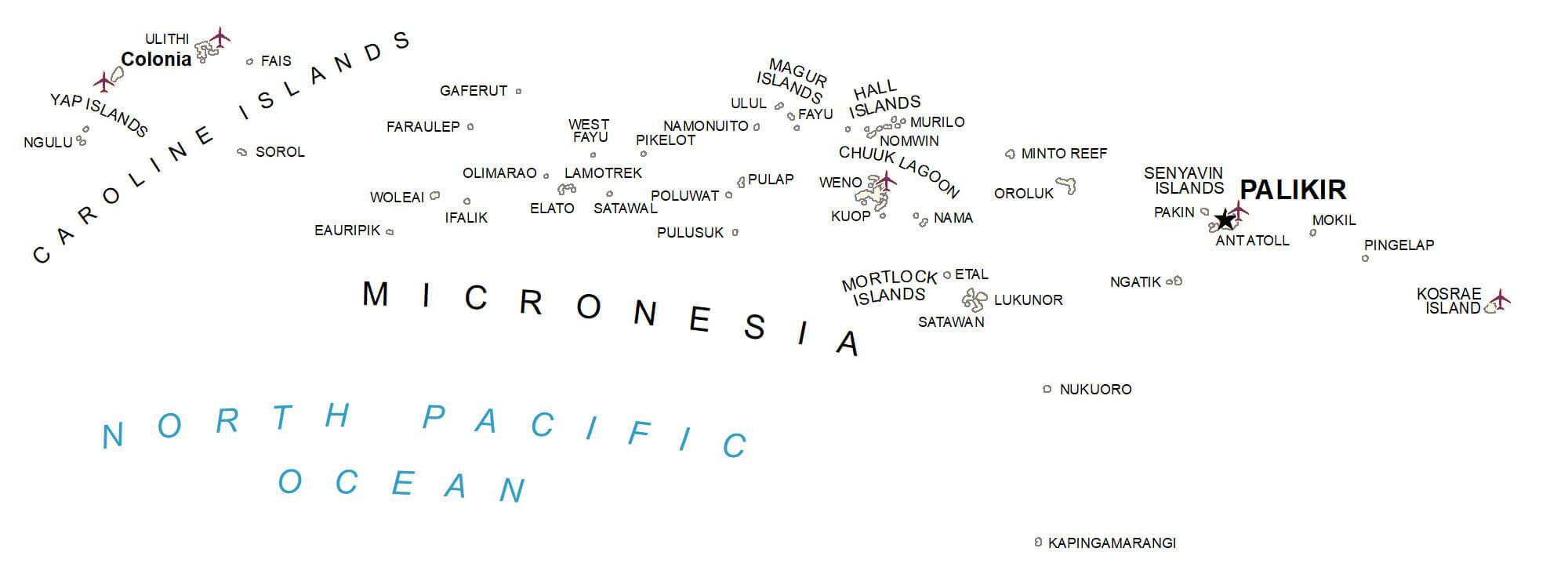
Covering a combined land area of 702 sq.km (271 sq mi), the Federated States of Micronesia is a sovereign island nation and an associated state of the United States comprising of about 607 islands and islets of the Caroline Islands Archipelago in North Pacific Ocean. Despite its small land area, FSM actually occupies 2,600,000 sq.km, of the Pacific Ocean and has the world’s 14th largest Exclusive Economic Zone. Located in the southern part of the Micronesian island of Pohnpei is, Mount Nanlaud – the highest point of FSM at an elevation of 2,566ft (782m). The islands of the Federated States of Micronesia are high volcanic islands, supporting a large variety of flora and low-lying coral atolls in poorer soil. The Pohnpei Island is the biggest, wettest and highest island in FSM as well as the most beautiful one in the country. It is an elevated island compared to its other islands which occupy lower altitudes. The landscape of the Pohnpei Island features mountains covered by dense rainforests, with mangrove swamps on the lower slopes. The island’s circumference is lined by coral reefs.
| Flag: |  |
|---|---|
| Legal Name: | Federated States of Micronesia |
| Capital Value: | Palikir |
| Demonym(s): | Micronesian |
| Government: | Federal assembly-independent republic under a non-partisan democracy |
| Legislature: | Congress |
| Total Area: | 702 km² |
| Land Area: | 702 km² |
| Population: | 113,815 |
| Density: | 158.1/km (409.5/sq mi) (75th) |
| GDP: | $401.93 Million |
| GDP Per Capita: | $3,568.29 |
| Currency Value: | US Dollar (USD) |
| Driving side: | right |
| Calling code: | +691 |
| Internet TLD: | .fm |
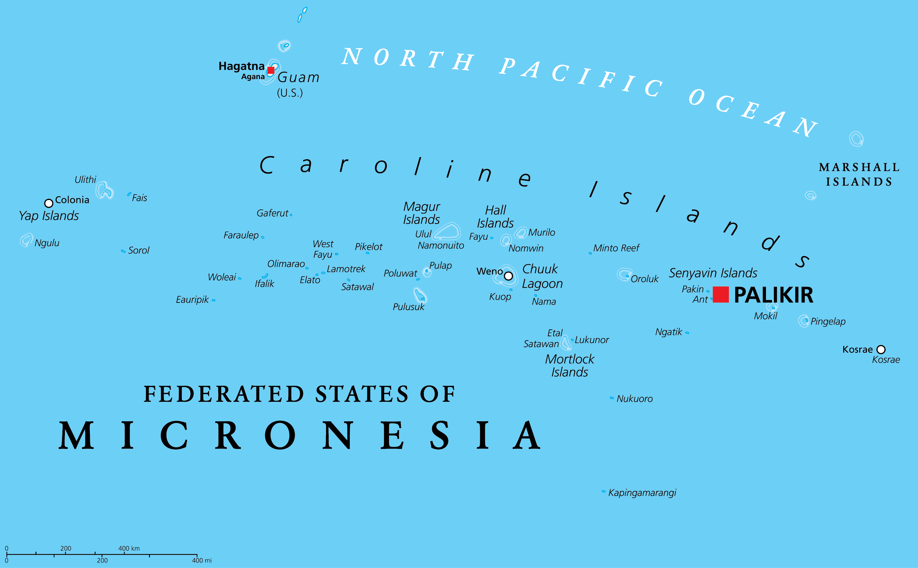
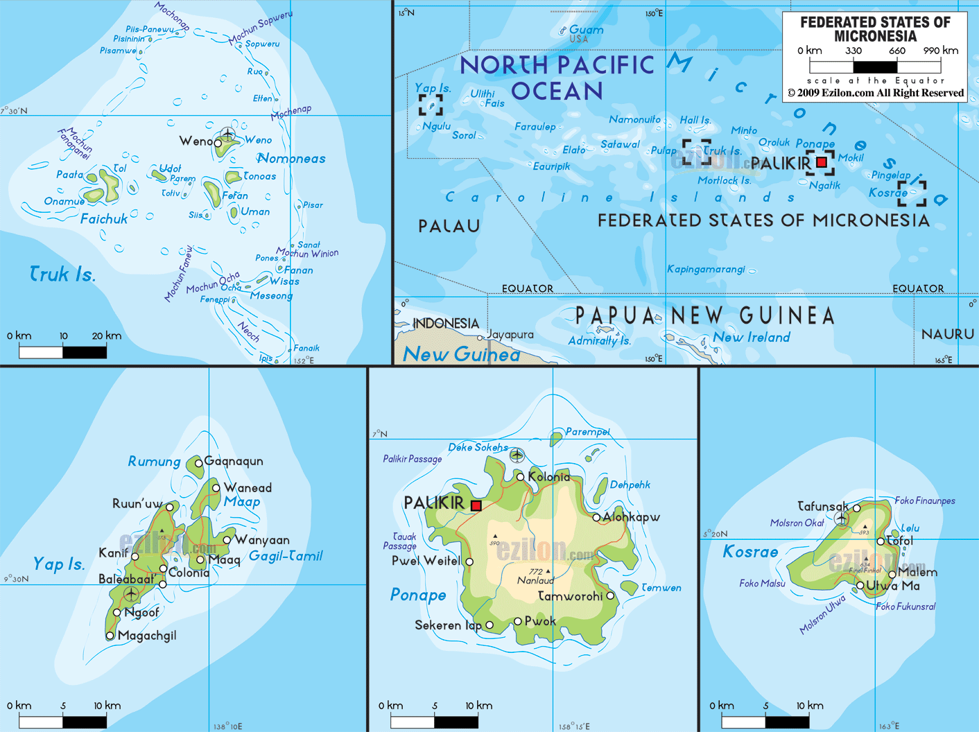
Discover the beauty of the Federated States of Micronesia with this detailed map. This map of Micronesia includes its major island chains like the Caroline Islands and the Mortlock Islands. It also includes its towns, atolls, and water features. It is a great tool for travelers and explorers alike, as it provides an in-depth look at the country and its fascinating geography.
Explore the islands of Micronesia with this detailed map. Get an up-close look at its major island chains like the Caroline Islands and the Mortlock Islands. See its towns, atolls, and water features. Travelers and explorers will benefit from this map as it provides an in-depth view of the country and its stunning geography.
Online Interactive Political Map
Click on ![]() to view map in "full screen" mode.
to view map in "full screen" mode.
Micronesia (The Federated States of Micronesia) is divided into 4 island states. In alphabetical order, these island states are: Chuuk (Truk), Kosrae (Kosaie), Pohnpei (Ponape) and Yap. These states are further subdivided into a number of cities and municipalities.
Covering a combined land area of 702 sq.km, the Federated States of Micronesia is an associated state of the United States and comprises of about 607 islands and islets of the Caroline Islands Archipelago in North Pacific Ocean.
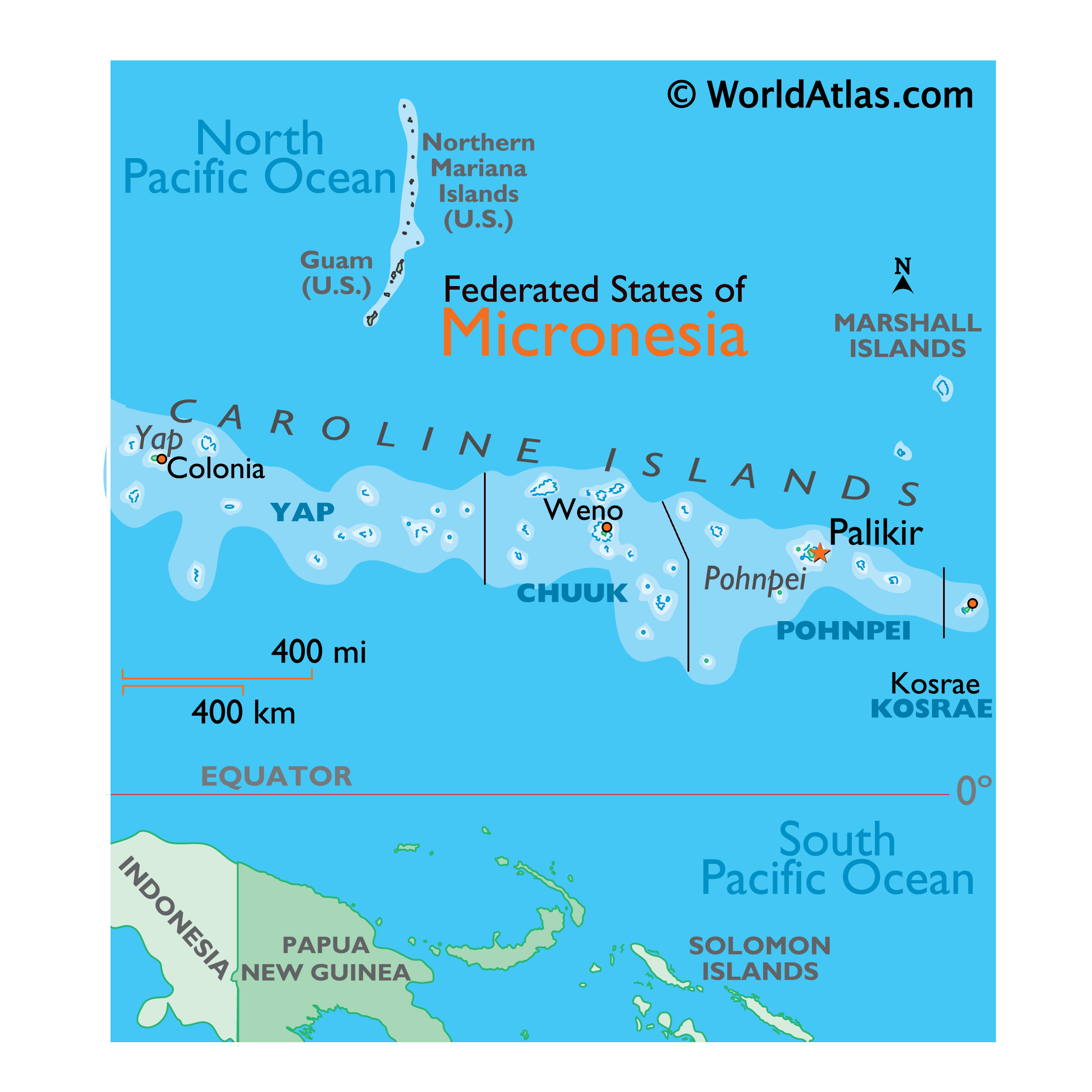
Located in Pohnpei Island’s (the largest and most populous island state) northwestern center is Palikir – the capital city of the Federated States of Micronesia. The coastal town of Kolonia is the largest settlement on the Pohnpei Island. It is the seat of the national government of the Federated States of Micronesia and is a relatively new urban area which is currently in a stage of growth and development. The largest city of Micronesia is Weno, which is located on the Chuuk Atoll in the west of Pohnpei.
Location Maps
Where is Micronesia?
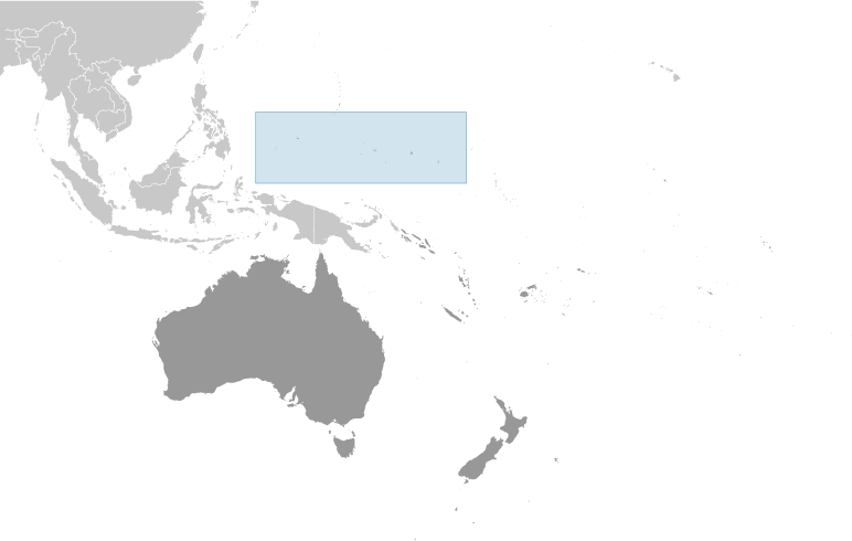
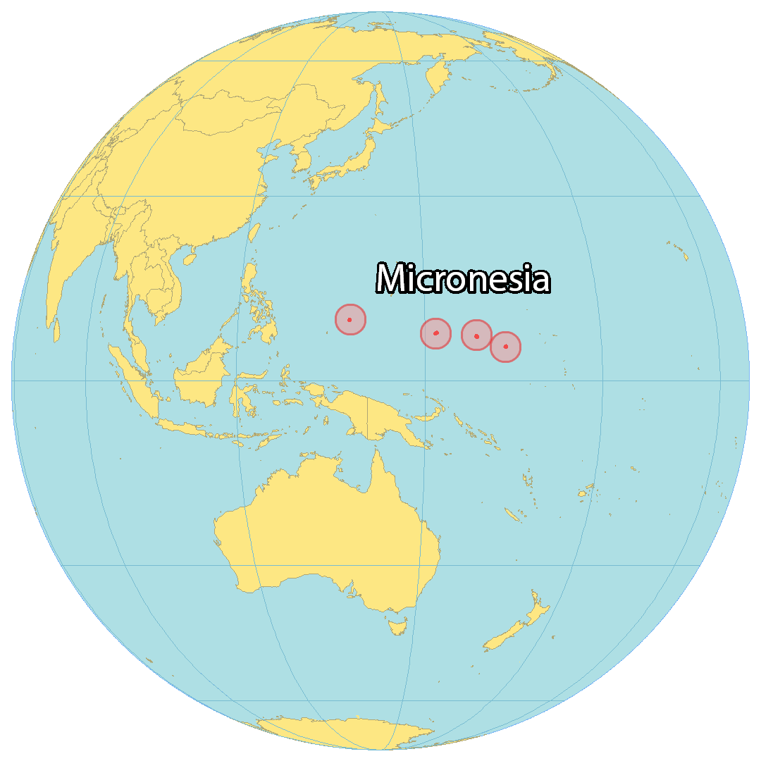
Micronesia is an island country in Oceania near Kiribati and the Marshall Islands, north of the equator. It encompasses 607 separate islands scattered across an area of 702 square kilometers (271 sq mi). Approximately 105,000 people are living in the Federated States of Micronesia, the most populous cities being Weno, Tofol, and Colonia. It consists of four states: Yap, Chuuk, Pohnpei, and Kosrae which are located in the North Pacific Ocean from west to east.
The Federated States of Micronesia is a popular destination for surfers, eco-tourists, and history buffs as it is home to many World War II sites. Additionally, it was used by the United States for running nuclear tests and setting up military bases.
High Definition Political Map of Micronesia
History
The ancestors of the Micronesians settled over four thousand years ago. A decentralized chieftain-based system eventually evolved into a more centralized economic and religious culture centered on Yap Island.
Nan Madol, a UNESCO World Heritage Site, consisting of a series of small artificial islands linked by a network of canals, is often called the Venice of the Pacific. It is located on the eastern periphery of the island of Pohnpei and used to be the ceremonial and political seat of the Saudeleur dynasty that united Pohnpei’s estimated 25,000 people from about AD 500 until 1500, when the centralized system collapsed.
European explorers—first the Portuguese in search of the Spice Islands (Indonesia) and then the Spanish—reached the Carolines in the sixteenth century. The Treaty of Tordesillas gave these lands to Spain and the Spanish incorporated the archipelago to the Spanish East Indies through the capital, Manila, and in the 19th century established a number of outposts and missions. In 1887, they founded the town of Santiago de la Ascensión in what today is Kolonia on the island of Pohnpei.
In the 1870s, Germany began extending its sphere of influence in the Caroline Islands, leading to the Carolines Question of 1885 in which Pope Leo XIII was asked to determine if Germany or Spain had authority over the islands. The result was a confirmation of Spanish authority over the islands, but Germany would have free access to the islands.
Following defeat in the Spanish–American War, the Spanish sold the archipelago to Germany in 1899 under the German–Spanish Treaty of 1899. Germany incorporated it into German New Guinea. (A few remote islands, notably Kapingamarangi, were not specifically named in the treaty, but this remained unnoticed until the late 1940s and, while acknowledging the historical curiosity in 1949, Spain has made no modern claims to the islands.)
During World War I, it was captured by Japan. Following the war, the League of Nations awarded a mandate for Japan to administer the islands as part of the South Seas Mandate.
During World War II, a significant portion of the Japanese fleet was based in Truk Lagoon. In February 1944, Operation Hailstone, one of the most important naval battles of the war, took place at Truk, in which many Japanese support vessels and aircraft were destroyed.
Following World War II, it was administered by the United States under United Nations auspices in 1947 as part of the Trust Territory of the Pacific Islands pursuant to Security Council Resolution 21.
On May 10, 1979, four of the Trust Territory districts ratified a new constitution to become the Federated States of Micronesia. Palau, the Marshall Islands, and the Northern Mariana Islands chose not to participate. The FSM signed a Compact of Free Association with the United States, which entered into force on November 3, 1986, marking Micronesia’s emergence from trusteeship to independence. Independence was formally concluded under international law in 1990, when the United Nations officially ended the Trusteeship status pursuant to Security Council Resolution 683. The Compact was renewed in 2004.
On June 22, 2015, the Federated States of Micronesia established the world’s second-largest regional shark sanctuary in the country’s exclusive economic zone covering nearly 3 million sq kilometers of western sea.
Physical Map of Micronesia
Geography
The Federated States of Micronesia consists of 607 islands extending 2,900 km (1,802 mi) across the archipelago of the Caroline Islands east of the Philippines. The islands have a combined area of 702 km (271 sq mi).
The islands are grouped into four states, which are Yap, Chuuk (called Truk until January 1990), Pohnpei (known as “Ponape” until November 1984), and Kosrae (formerly Kusaie). These four states are each represented by a white star on the national flag. The capital is Palikir, on Pohnpei.
Two terrestrial ecoregions lie within the country’s borders: Carolines tropical moist forests and Yap tropical dry forests. It had a 2019 Forest Landscape Integrity Index mean score of 7.55/10, ranking it 37th globally out of 172 countries.
Biodiversity
The major coastal communities are mangrove forests, seagrass beds, lagoons and coral reefs, biologically and physically linked. About 300 species of coral, 1000 species of fish and 1200 species of mollusks are recognized in Micronesia. In the mangrove forests there are shrimps, crabs and fish, as well as birds that feed on them. Seagrass meadows appear offshore following the mangroves. The lagoons provide food for the reef inhabitants and contain various kinds of plankton. The biodiversity and complexity of the coral reefs increases markedly from east to west, with 150 species of hard coral at Kosrae, 200 at Pohnpei and 300 at Chuuk. Coral productivity in this area is among the highest in the world, absorbing about 2500 grams of carbon per square meter per year, against 2200 grams in the tropical forest and 125 grams in the open sea.
Inland, from the tidal zone to the top of the mountains there is a varied range of vegetation, cloud forest, upland, palm, plantation, areas dominated by climbers of the genus Merremia, savannas, native secondary forest, fragments of introduced trees, cultivated areas, freshwater swamps, swamps of the palm Nypa fruticans, atoll forests, forests in rocky areas and beaches. There are about 1230 species of ferns and flowering plants, of which 782 are native, including 145 native fern species. On Pohnpei Island, there are about 750 plant species, of which 110 are endemic. Another 457 species have been introduced.
Climate
The Federated States of Micronesia has a tropical rainforest climate (Köppen: Af). The weather is warm, humid and rainy all year round. The islands are located north of the equator and are affected by constant trade winds, which temper the climate. Minimum temperatures range all year round between 22 and 25°C, and maximum temperatures between 30 and 32°C. The abundant precipitations oscillate between 2500 and 5000 mm per year, although in the faces oriented to the wind they can surpass 6000 mm. Mount Nahnalaud, only 750 m high, on the island of Pohnpei, receives an average of 10,160 mm, being one of the rainiest places on earth, with almost always overcast skies. In general, the rains are produced by showers and storms of short duration but very intense. The driest places are the flat atolls, where rainfall can drop below 3000 mm. The driest months are January and February, with no less than 250 mm and 20 days of rain.