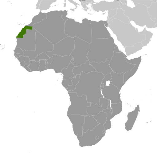
Western Sahara is located in North Africa, bordering the Atlantic Ocean. It is nearly entirely covered by the Sahara Desert, the largest desert in the world. Subsequently, the landscape is mostly low, flat desert representing one of the Earth’s most inhospitable areas. Wadis or dry river beds that sometimes have intermittent flowing rivers dot the landscape in many parts. Water being the scarcest resource here, Western Sahara is one of the world’s most sparsely populated areas.
| Flag: |  |
|---|---|
| Legal Name: | Western Sahara |
| Total Area: | 266,000 km² |
| Land Area: | 266,000 km² |
| Population: | 619,551 |
| Density: | 2.03/km (5.3/sq mi) |
| Currency Value: | Moroccan dirhams (MAD) |
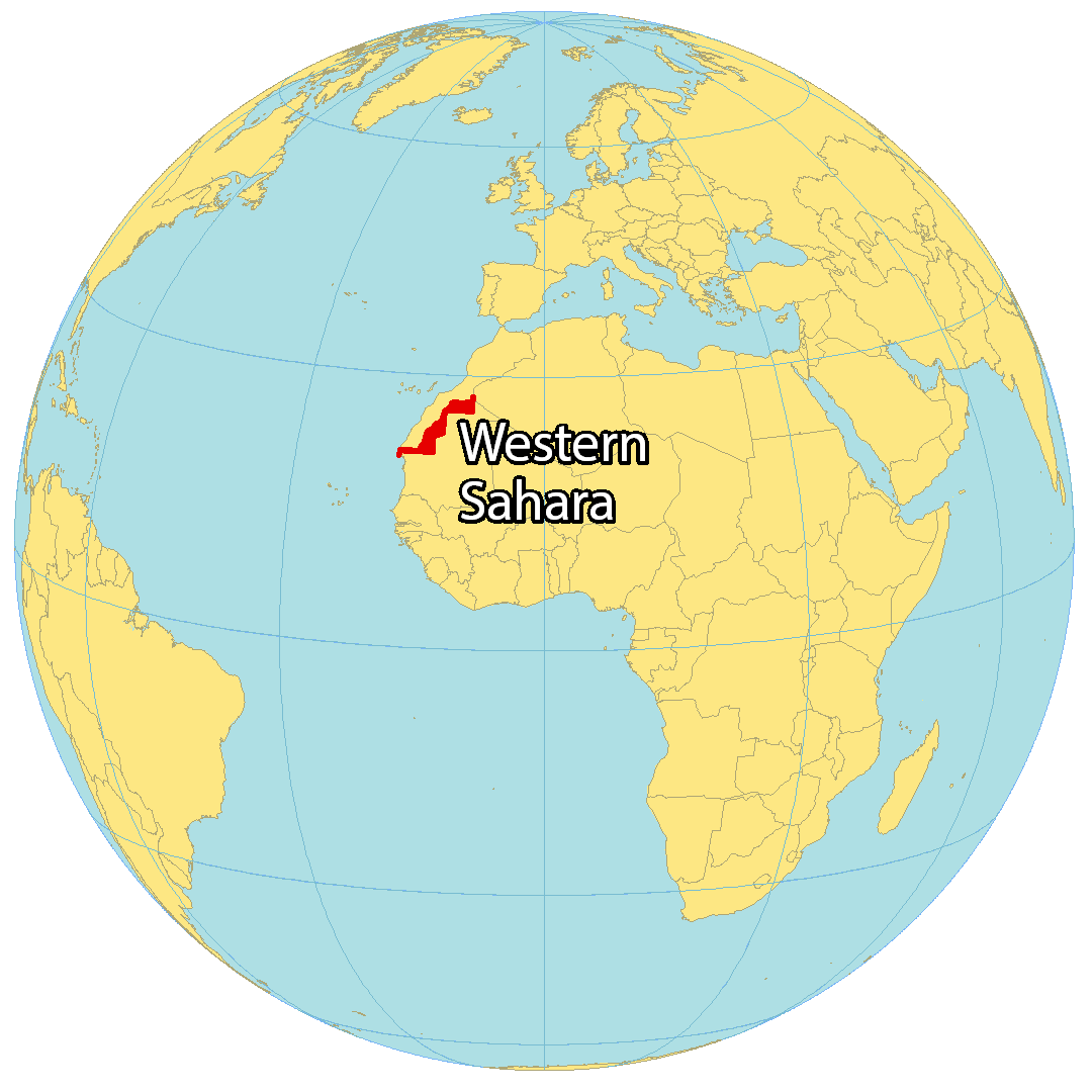
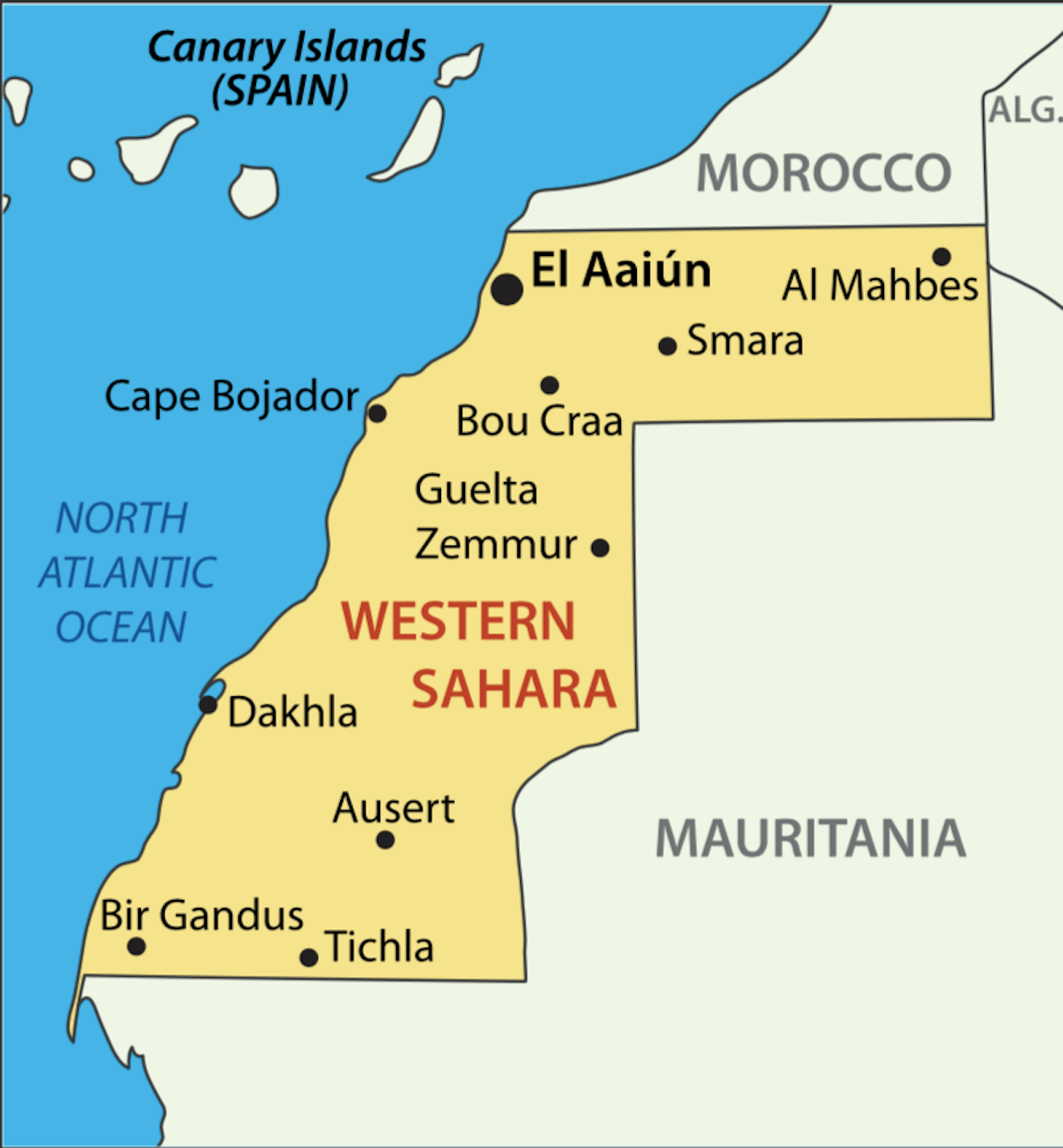
The Western Sahara is a disputed region situated in Northwest Africa. The region, which is bordered by Morocco, Mauritania, and Algeria, is a source of ongoing political unrest. To help gain a better understanding of the area, we’ve compiled a Western Sahara map featuring a reference map, satellite imagery, and an elevation map of the region.
Online Interactive Political Map
Click on ![]() to view map in "full screen" mode.
to view map in "full screen" mode.
Western Sahara is a disputed territory and as such, does not have any official administrative divisions of its own. The political status of Western Sahara is considered undetermined by the US Government. 80% of the territory is controlled and administered by Morocco. Portions of the regions Guelmim-Es Smara and Laayoune-Boujdour-Sakia El Hamra, as claimed by Morocco, lie within Western Sahara; Morocco also claims Oued Eddahab-Lagouira, another region that falls entirely within Western Sahara.
The remaining 20% is under the control of the self-proclaimed Sahrawi Arab Democratic Republic.
Western Sahara does not have an official national capital. Laayoune (El Aaiún) is the largest city.
Location Maps
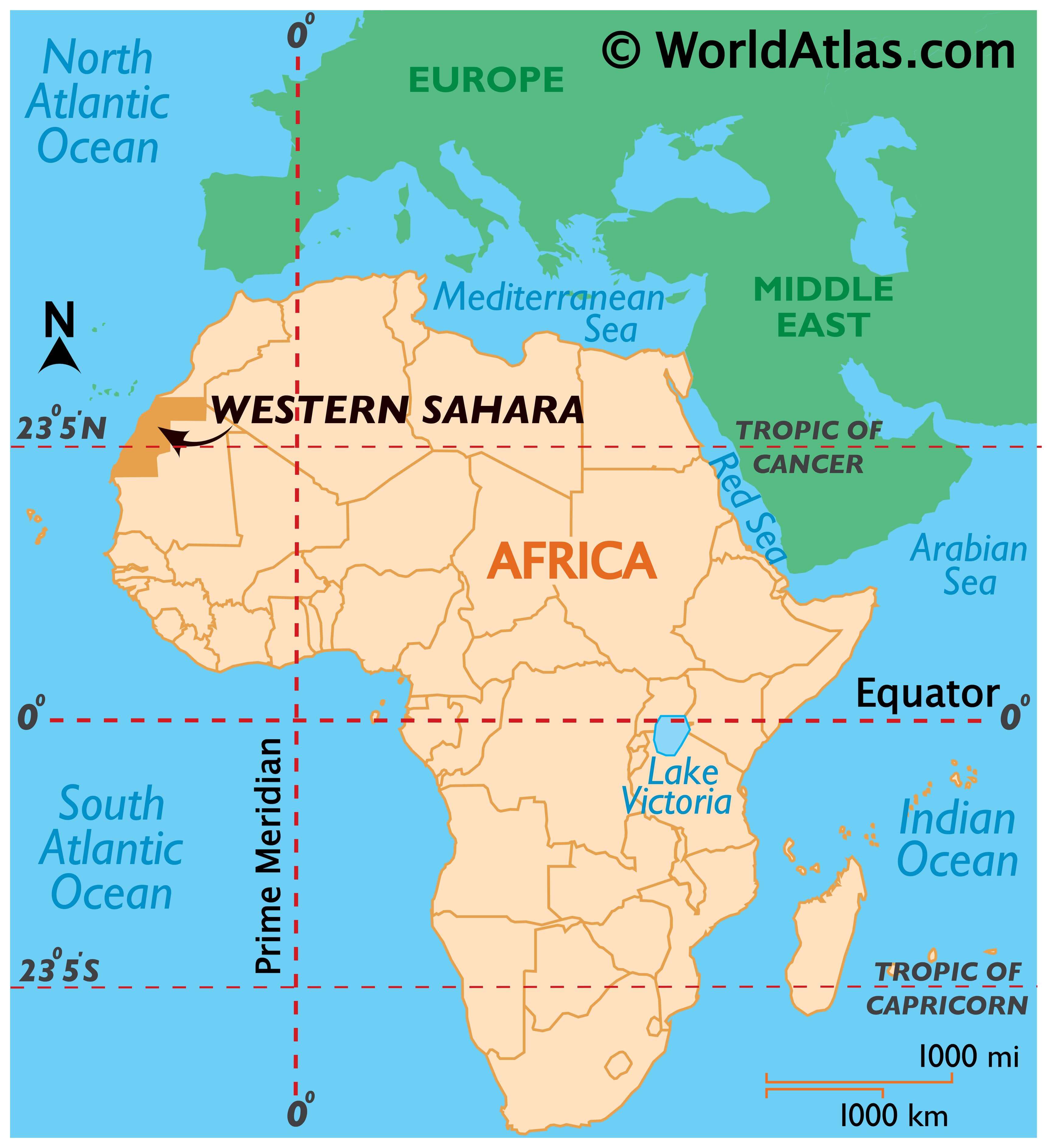
Where is Western Sahara?
Western Sahara is a disputed territory located along the northwest coast of Africa. While Morocco administers about 80% of the region, the partially-recognized Sahrawi Arab Democratic Republic administers the remaining one-fifth of Western Sahara. The claimed capital is the largest city in Western Sahara, El Aaiún. But Tifariti is the temporary (de facto) capital close to its border with Mauritania. Altogether, it borders three nations including Morocco to the north, Algeria to the east, and Mauritania to the south.
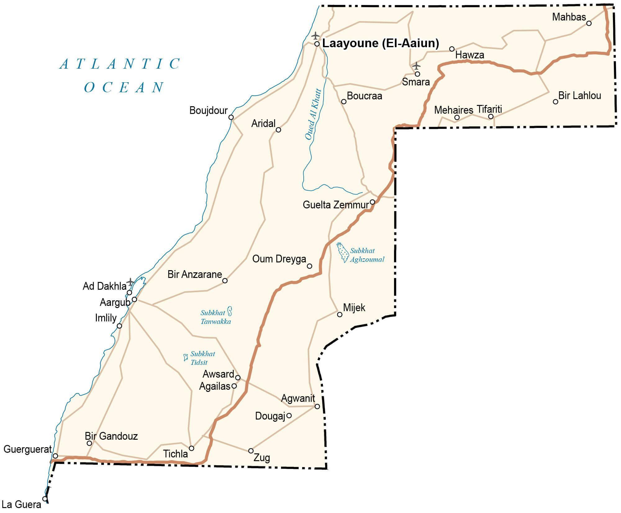
High Definition Political Map of Western Sahara
History
Early history
The earliest known inhabitants of Western Sahara were the Gaetuli. Depending on the century, Roman-era sources describe the area as inhabited by Gaetulian Autololes or the Gaetulian Daradae tribes. Berber heritage is still evident from regional and place-name toponymy, as well as from tribal names.
Other early inhabitants of Western Sahara may be the Bafour and later the Serer. The Bafour were later replaced or absorbed by Berber-speaking populations, which eventually merged in turn with the migrating Beni Ḥassān Arab tribes.
The arrival of Islam in the 8th century played a major role in the development of the Maghreb region. Trade developed further, and the territory may have been one of the routes for caravans, especially between Marrakesh and Tombouctou in Mali.
In the 11th century, the Maqil Arabs (fewer than 200 individuals) settled in Morocco (mainly in the Draa River valley, between the Moulouya River, Tafilalt and Taourirt). Towards the end of the Almohad Caliphate, the Beni Hassan, a sub-tribe of the Maqil, were called by the local ruler of the Sous to quell a rebellion; they settled in the Sous Ksours and controlled such cities as Taroudant. During Marinid dynasty rule, the Beni Hassan rebelled but were defeated by the Sultan and escaped beyond the Saguia el-Hamra dry river. The Beni Hassan then were at constant war with the Lamtuna nomadic Berbers of the Sahara. Over roughly five centuries, through a complex process of acculturation and mixing seen elsewhere in the Maghreb and North Africa, some of the indigenous Berber tribes mixed with the Maqil Arab tribes and formed a culture unique to Morocco and Mauritania.
Spanish province
While initial Spanish interest in the Sahara was focused on using it as a port for the slave trade, by the 1700s Spain had transitioned economic activity on the Saharan coast towards commercial fishing. After an agreement among the European colonial powers at the Berlin Conference in 1884 on the division of spheres of influence in Africa, Spain seized control of Western Sahara and established it as a Spanish colony. After 1939 and the outbreak of World War II, this area was administered by Spanish Morocco. As a consequence, Ahmed Belbachir Haskouri, the Chief of Cabinet, General Secretary of the Government of Spanish Morocco, cooperated with the Spanish to select governors in that area. The Saharan lords who were already in prominent positions, such as the members of Maa El Ainain family, provided a recommended list of candidates for new governors. Together with the Spanish High Commissioner, Belbachir selected from this list. During the annual celebration of Muhammad’s birthday, these lords paid their respects to the caliph to show loyalty to the Moroccan monarchy.
As time went by, Spanish colonial rule began to unravel with the general wave of decolonization after World War II; former North African and sub-Saharan African possessions and protectorates gained independence from European powers. Spanish decolonization proceeded more slowly, but internal political and social pressures for it in mainland Spain built up towards the end of Francisco Franco’s rule. There was a global trend towards complete decolonization. Spain began rapidly to divest itself of most of its remaining colonial possessions. By 1974–75 the government issued promises of a referendum on independence in Western Sahara.
At the same time, Morocco and Mauritania, which had historical and competing claims of sovereignty over the territory, argued that it had been artificially separated from their territories by the European colonial powers. Algeria, which also bordered the territory, viewed their demands with suspicion, as Morocco also claimed the Algerian provinces of Tindouf and Béchar. After arguing for a process of decolonization to be guided by the United Nations, the Algerian government under Houari Boumédiènne in 1975 committed to assisting the Polisario Front, which opposed both Moroccan and Mauritanian claims and demanded full independence of Western Sahara.
The UN attempted to settle these disputes through a visiting mission in late 1975, as well as a verdict from the International Court of Justice (ICJ). It acknowledged that Western Sahara had historical links with Morocco and Mauritania, but not sufficient to prove the sovereignty of either State over the territory at the time of the Spanish colonization. The population of the territory thus possessed the right of self-determination. On 6 November 1975 Morocco initiated the Green March into Western Sahara; 350,000 unarmed Moroccans converged on the city of Tarfaya in southern Morocco and waited for a signal from King Hassan II of Morocco to cross the border in a peaceful march. A few days before, on 31 October, Moroccan troops invaded Western Sahara from the north.
Demands for independence
In the waning days of General Franco’s rule, and after the Green March, the Spanish government signed a tripartite agreement with Morocco and Mauritania as it moved to transfer the territory on 14 November 1975. The accords were based on a bipartite administration, and Morocco and Mauritania each moved to annex the territories, with Morocco taking control of the northern two-thirds of Western Sahara as its Southern Provinces, and Mauritania taking control of the southern third as Tiris al-Gharbiyya. Spain terminated its presence in Spanish Sahara within three months, repatriating Spanish remains from its cemeteries.
The Moroccan and Mauritanian annexations were resisted by the Polisario Front, which had gained backing from Algeria. It initiated guerrilla warfare and, in 1979, Mauritania withdrew due to pressure from Polisario, including a bombardment of its capital and other economic targets. Morocco extended its control to the rest of the territory. It gradually contained the guerrillas by setting up the extensive sand-berm in the desert (known as the Border Wall or Moroccan Wall) to exclude guerrilla fighters. Hostilities ceased in a 1991 cease-fire, overseen by the peacekeeping mission MINURSO, under the terms of a UN Settlement Plan.
Stalling of the referendum and Settlement Plan
The referendum, originally scheduled for 1992, foresaw giving the local population the option between independence or affirming integration with Morocco, but it quickly stalled. In 1997, the Houston Agreement attempted to revive the proposal for a referendum but likewise has hitherto not had success. As of 2010, negotiations over terms have not resulted in any substantive action. At the heart of the dispute lies the question of who qualifies to be registered to participate in the referendum, and, since about the year 2000, Morocco considers that since there is no agreement on persons entitled to vote, a referendum is not possible. Meanwhile, Polisario still insisted on a referendum with independence as a clear option, without offering a solution to the problem of who is qualified to be registered to participate in it.
Both sides blame each other for the stalling of the referendum. The Polisario has insisted on only allowing those found on the 1974 Spanish Census lists (see below) to vote, while Morocco has insisted that the census was flawed by evasion and sought the inclusion of members of Sahrawi tribes that escaped from Spanish invasion to the north of Morocco by the 19th century.
Efforts by the UN special envoys to find a common ground for both parties did not succeed. By 1999 the UN had identified about 85,000 voters, with nearly half of them in the Moroccan-controlled parts of Western Sahara or Southern Morocco, and the others scattered between the Tindouf refugee camps, Mauritania and other places of exile. Polisario accepted this voter list, as it had done with the previous list presented by the UN (both of them originally based on the Spanish census of 1974), but Morocco refused and, as rejected voter candidates began a mass-appeals procedure, insisted that each application be scrutinized individually. This again brought the process to a halt.
According to a NATO delegation, MINURSO election observers stated in 1999, as the deadlock continued, that “if the number of voters does not rise significantly the odds were slightly on the SADR side”. By 2001, the process had effectively stalemated and the UN Secretary-General asked the parties for the first time to explore other, third-way solutions. Indeed, shortly after the Houston Agreement (1997), Morocco officially declared that it was “no longer necessary” to include an option of independence on the ballot, offering instead autonomy. Erik Jensen, who played an administrative role in MINURSO, wrote that neither side would agree to a voter registration in which they were destined to lose (see Western Sahara: Anatomy of a Stalemate).
Baker Plan
As personal envoy of the Secretary-General, James Baker visited all sides and produced the document known as the “Baker Plan”. This was discussed by the United Nations Security Council in 2000, and envisioned an autonomous Western Sahara Authority (WSA), which would be followed after five years by the referendum. Every person present in the territory would be allowed to vote, regardless of birthplace and with no regard to the Spanish census. It was rejected by both sides, although it was initially derived from a Moroccan proposal. According to Baker’s draft, tens of thousands of post-annexation immigrants from Morocco proper (viewed by Polisario as settlers but by Morocco as legitimate inhabitants of the area) would be granted the vote in the Sahrawi independence referendum, and the ballot would be split three ways by the inclusion of an unspecified “autonomy”, further undermining the independence camp. Morocco was also allowed to keep its army in the area and retain control over all security issues during both the autonomy years and the election. In 2002, the Moroccan king stated that the referendum idea was “out of date” since it “cannot be implemented”; Polisario retorted that that was only because of the King’s refusal to allow it to take place.
In 2003, a new version of the plan was made official, with some additions spelling out the powers of the WSA, making it less reliant on Moroccan devolution. It also provided further detail on the referendum process in order to make it harder to stall or subvert. This second draft, commonly known as Baker II, was accepted by the Polisario as a “basis of negotiations” to the surprise of many. This appeared to abandon Polisario’s previous position of only negotiating based on the standards of voter identification from 1991 (i.e. the Spanish census). After that, the draft quickly garnered widespread international support, culminating in the UN Security Council’s unanimous endorsement of the plan in the summer of 2003.
End of the 2000s
Baker resigned his post at the United Nations in 2004; his term did not see the crisis resolved. His resignation followed several months of failed attempts to get Morocco to enter into formal negotiations on the plan, but he was met with rejection.
King Hassan II of Morocco initially supported the referendum idea in principle in 1982, and signed contracts with Polisario and the UN in 1991 and 1997. No major powers have expressed interest in forcing the issue, however, and Morocco has shown little interest in a real referendum. Hassan II’s son and successor, Mohammed VI, has opposed any referendum on independence, and has said Morocco will never agree to one: “We shall not give up one inch of our beloved Sahara, not a grain of its sand.” In 2006, he created an appointed advisory body Royal Advisory Council for Saharan Affairs (CORCAS), which proposes a self-governing Western Sahara as an autonomous community within Morocco.
The UN has put forth no replacement strategy after the breakdown of Baker II, and renewed fighting has been raised as a possibility. In 2005, former United Nations Secretary-General Kofi Annan reported increased military activity on both sides of the front and breaches of several cease-fire provisions against strengthening military fortifications.
Morocco has repeatedly tried to engage Algeria in bilateral negotiations, based on its view of Polisario as the cat’s paw of the Algerian military. It has received vocal support from France and occasionally (and currently) from the United States. These negotiations would define the exact limits of a Western Sahara autonomy under Moroccan rule but only after Morocco’s “inalienable right” to the territory was recognized as a precondition to the talks. The Algerian government has consistently refused, claiming it has neither the will nor the right to negotiate on the behalf of the Polisario Front.
Demonstrations and riots by supporters of independence or a referendum broke out in the Moroccan-controlled parts of Western Sahara in May 2005 and in parts of southern Morocco (notably the town of Assa). They were met by police. Several international human rights organizations expressed concern at what they termed abuse by Moroccan security forces, and a number of Sahrawi activists have been jailed. Pro-independence Sahrawi sources, including the Polisario, have given these demonstrations the name “Independence Intifada”, while most sources have tended to see the events as being of limited importance. International press and other media coverage have been sparse, and reporting is complicated by the Moroccan government’s policy of strictly controlling independent media coverage within the territory.
Demonstrations and protests still occur, even after Morocco declared in February 2006 that it was contemplating a plan for devolving a limited variant of autonomy to the territory but still explicitly refused any referendum on independence. As of January 2007, the plan had not been made public, though the Moroccan government claimed that it was more or less complete.
Polisario has intermittently threatened to resume fighting, referring to the Moroccan refusal of a referendum as a breach of the cease-fire terms, but most observers seem to consider armed conflict unlikely without the green light from Algeria, which houses the Sahrawis’ refugee camps and has been the main military sponsor of the movement.
In April 2007, the government of Morocco suggested that a self-governing entity, through the CORCAS, should govern the territory with some degree of autonomy for Western Sahara. The project was presented to the UN Security Council in mid-April 2007. The stalemating of the Moroccan proposal options has led the UN in the recent “Report of the UN Secretary-General” to ask the parties to enter into direct and unconditional negotiations to reach a mutually accepted political solution.
The 2010s
In October 2010 Gadaym Izik camp was set up near Laayoune as a protest by displaced Sahrawi people about their living conditions. It was home to more than 12,000 people. In November 2010 Moroccan security forces entered Gadaym Izik camp in the early hours of the morning, using helicopters and water cannon to force people to leave. The Polisario Front said Moroccan security forces had killed a 26-year-old protester at the camp, a claim denied by Morocco. Protesters in Laayoune threw stones at police and set fire to tires and vehicles. Several buildings, including a TV station, were also set on fire. Moroccan officials said five security personnel had been killed in the unrest.
On 15 November 2010, the Moroccan government accused the Algerian secret services of orchestrating and financing the Gadaym Izik camp with the intent to destabilize the region. The Spanish press was accused of mounting a campaign of disinformation to support the Sahrawi initiative, and all foreign reporters were either prevented from traveling or else expelled from the area. The protest coincided with a fresh round of negotiations at the UN.
In 2016, the European Union (EU) declared that “Western Sahara is not part of Moroccan territory.” In March 2016, Morocco “expelled more than 70 U.N. civilian staffers with MINURSO” due to strained relations after Ban Ki-moon called Morocco’s annexation of Western Sahara an “occupation”.
The 2020s
In November 2020, the ceasefire between the Polisario Front and Morocco broke down, leading to armed clashes between both sides.
On 10 December 2020, the United States announced that it would recognize full Moroccan sovereignty over Western Sahara in exchange for Morocco establishing relations with Israel.
In February 2021, Morocco proposed to Spain the creation of an autonomy for Western Sahara under the sovereignty of the King of Morocco.
In March 2022, the Spanish government abandoned its traditional position of neutrality in the conflict, siding with Rabat and recognising the autonomy proposal “as the most serious, realistic and credible basis for the resolution of the dispute”. This sudden turnaround was generally rejected by both the Opposition, the parties that make up the government coalition, the Polisario Front, as well as members of the governing party, who support a solution “that respects the democratic will of the Saharawi people”.
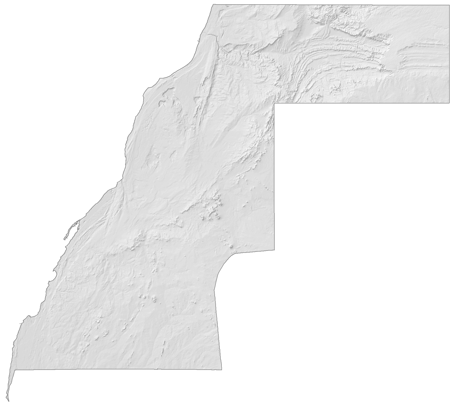
Physical Map of Western Sahara
Western Sahara Satellite Map
Elevation Map