Covering an area of only 6.7 sq. km, the British Overseas Territory of Gibraltar is located at the southern edge of the Iberian Peninsula in southwestern Europe.
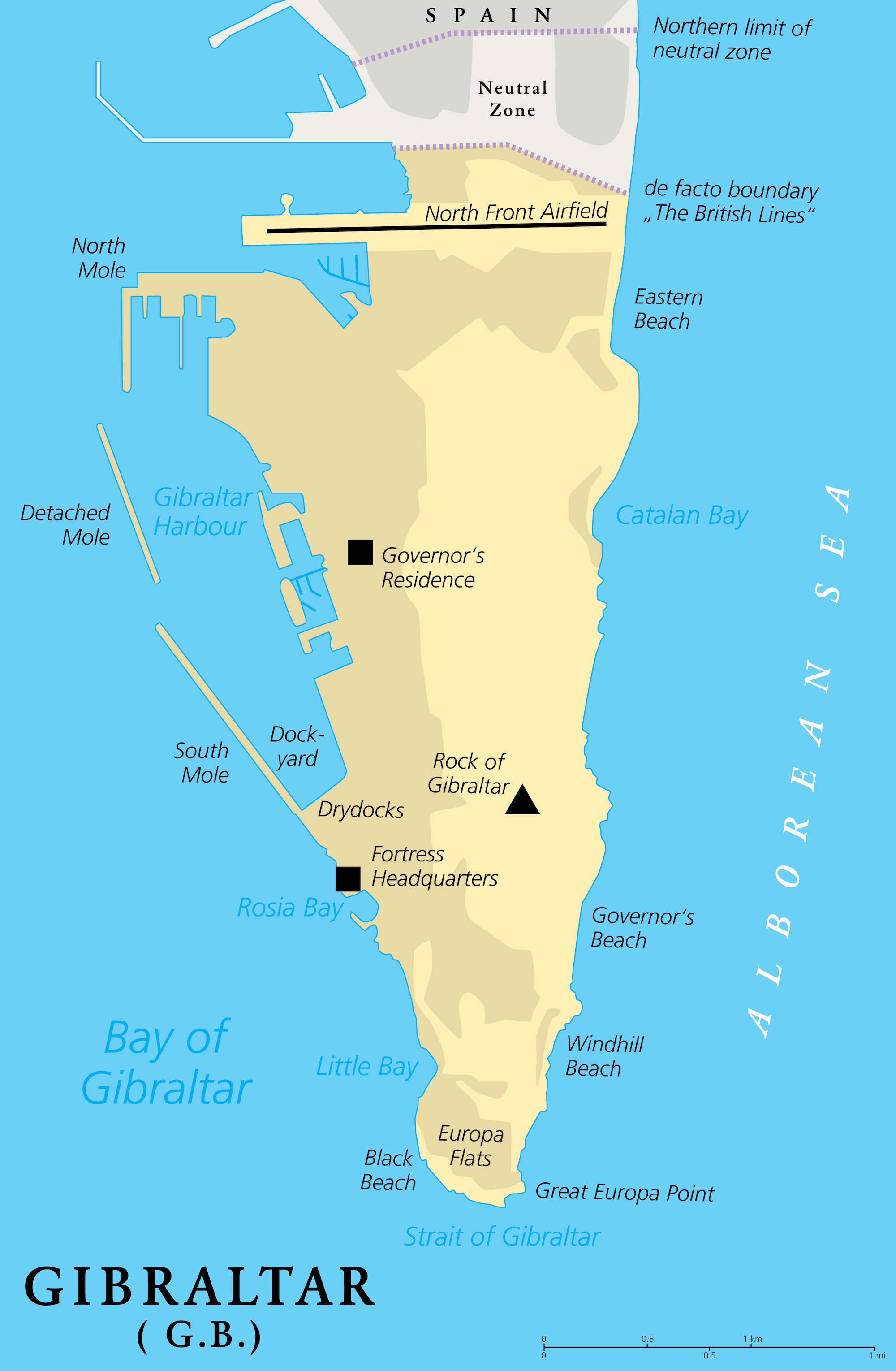
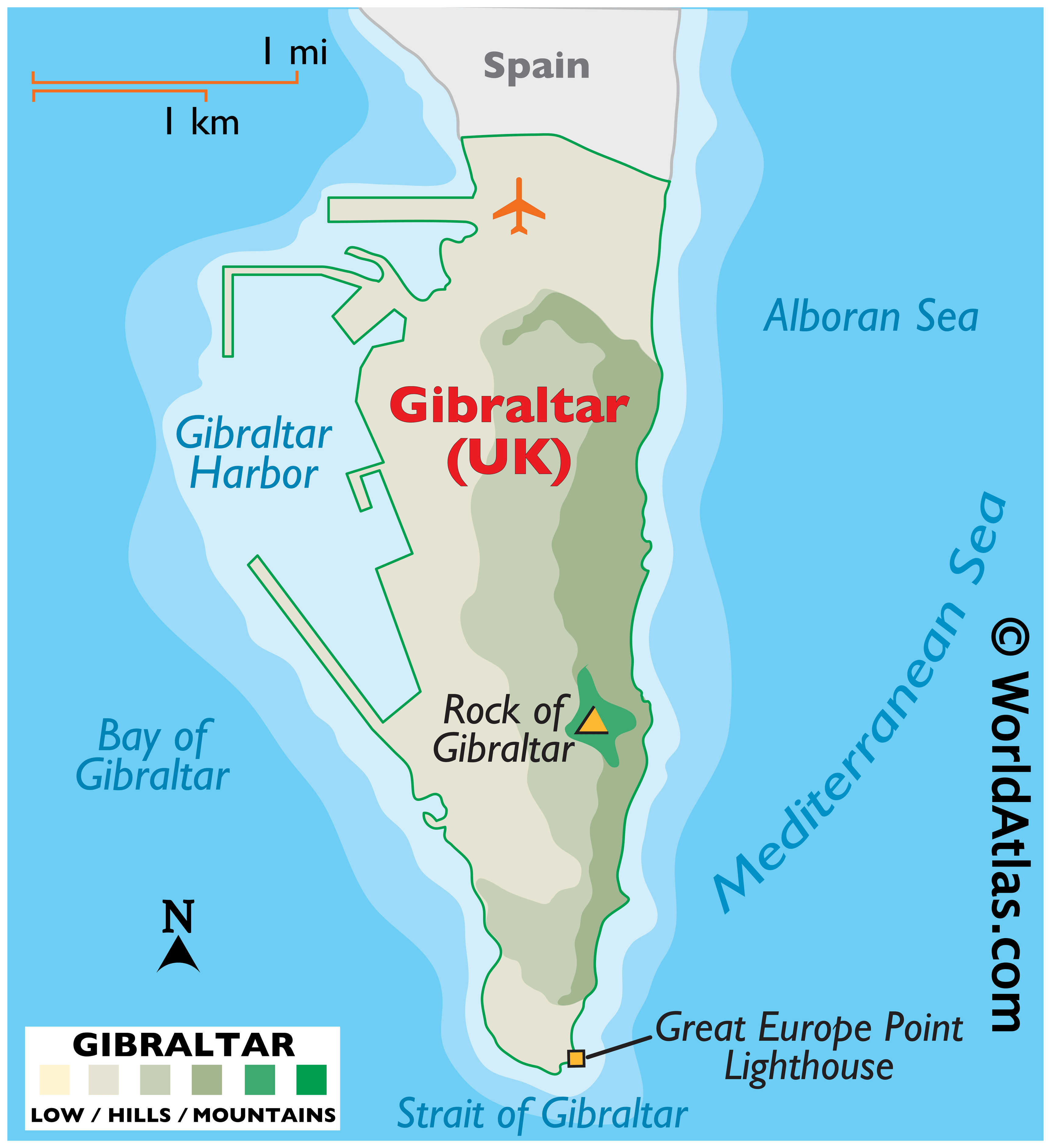
As marked on the map by an upright yellow triangle, the Rock of Gibraltar is the most significant landmark of the region. This spectacular rock monolith rises to an elevation of 1396ft (426m) and is also the territory’s highest point. The surrounding land is close to the sea level and consists of a few sandy beaches. There are no rivers in Gibraltar. The territory’s lowest point is at the Mediterranean Sea (0m).
| Legal Name: | Gibraltar |
|---|---|
| Capital Value: | Gibraltar |
| Official languages: | English |
| Demonym(s): |
|
| Government: | Devolved representative democratic parliamentary dependency under a constitutional monarchy |
| Legislature: | Parliament |
| Total Area: | 6 km² |
| Land Area: | 6 km² |
| Population: | 33,701 |
| Density: | 5,000/km (12,949.9/sq mi) |
| Currency Value: | Gibraltar pounds (GIP) |
| Driving side: | right |
| Calling code: | +350 |
| Internet TLD: | .gi |
Location Maps
Where is Gibraltar?

High Definition Political Map of Gibraltar
History
Prehistory and ancient history
Evidence of Neanderthal habitation in Gibraltar from around 50,000 years ago has been discovered at Gorham’s Cave. The caves of Gibraltar continued to be used by Homo sapiens after the final extinction of the Neanderthals. Stone tools, ancient hearths and animal bones dating from around 40,000 years ago to about 5,000 years ago have been found in deposits left in Gorham’s Cave.
Numerous potsherds dating from the Neolithic period have been found in Gibraltar’s caves, mostly of types typical of the Almerian culture found elsewhere in Andalusia, especially around the town of Almería, from which it takes its name. There is little evidence of habitation in the Bronze Age when people had largely stopped living in caves.
During ancient times, Gibraltar was regarded by the peoples of the Mediterranean as a place of religious and symbolic importance. The Phoenicians were present for several centuries since around 950 BC, apparently using Gorham’s Cave as a shrine to the genius loci, as did the Carthaginians and Romans after them. Gibraltar was known as Mons Calpe, a name perhaps of Phoenician origin. Mons Calpe was considered by the ancient Greeks and Romans as one of the Pillars of Hercules, after the Greek legend of the creation of the Strait of Gibraltar by Heracles. There is no known archaeological evidence of permanent settlements from the ancient period. They settled at the head of the bay in what is today known as the Campo (hinterland) of Gibraltar. The town of Carteia, near the location of the modern Spanish town of San Roque, was founded by the Phoenicians around 950 BC on the site of an early settlement of the native Turdetani people.
Middle Ages
After the collapse of the Western Roman Empire, Gibraltar came briefly under the control of the Vandals, who crossed into Africa at the invitation of Boniface, the Count (or commander) of the territory.
The area later formed part of the Visigothic Kingdom of Hispania for almost 300 years, from 414 until 711 AD.
Following a raid in 710, a predominantly Berber army under the command of Tariq ibn Ziyad crossed from North Africa in April 711 and landed somewhere in the vicinity of Gibraltar (though most likely not in the bay or at the Rock itself). Tariq’s expedition led to the Islamic conquest of most of the Iberian peninsula. Mons Calpe was renamed Jabal Ṭāriq (جبل طارق), “the Mount of Tariq”, subsequently corrupted into Gibraltar.
In 1160 the Almohad Sultan Abd al-Mu’min ordered that a permanent settlement, including a castle, be built. It received the name of Medinat al-Fath (City of the Victory). The Tower of Homage of the Moorish Castle remains standing today.
From 1274 onwards, the town was fought over and captured by the Nasrids of Granada (in 1237 and 1374), the Marinids of Morocco (in 1274 and 1333) and the kings of Castile (in 1309).
Modern era
In 1462, Gibraltar was captured by Juan Alonso de Guzmán, 1st Duke of Medina Sidonia, from the Emirate of Granada.
After the conquest, Henry IV of Castile assumed the additional title of King of Gibraltar, establishing it as part of the comarca of the Campo Llano de Gibraltar. Six years later, Gibraltar was restored to the Duke of Medina Sidonia, who sold it in 1474 to a group of 4,350 conversos (Christian converts from Judaism) from Cordova and Seville and in exchange for maintaining the garrison of the town for two years, after which time they were expelled, returning to their home towns or moving on to other parts of Spain. In 1501, Gibraltar passed back to the Spanish Crown, and Isabella I of Castile issued a Royal Warrant granting Gibraltar the coat of arms that it still uses.
In 1704, during the War of the Spanish Succession, a combined Anglo-Dutch fleet, representing the Grand Alliance, captured the town of Gibraltar on behalf of the Archduke Charles of Austria in his campaign to become King of Spain. Subsequently, most of the population left the town, with many settling nearby. As the Alliance’s campaign faltered, the 1713 Treaty of Utrecht was negotiated, which ceded control of Gibraltar to Britain to secure Britain’s withdrawal from the war. Unsuccessful attempts by Spanish monarchs to regain Gibraltar were made, with the siege of 1727, and again with the Great Siege of Gibraltar (1779 to 1783), during the American War of Independence.
After the destructive Great Siege, the town was almost entirely rebuilt. Giovanni Maria Boschetti, who arrived in Gibraltar in 1784 as a 25-year-old from Milan, where he is thought to have been a stonemason or engineer, built the Victualling Yard (completed in 1812) and many other buildings. Boschetti is regarded as having been responsible for setting the old town’s style, described by Claire Montado, chief executive of the Gibraltar Heritage Trust, as “military-ordnance-style arched doorways, Italianate stucco relief, Genoese shutters, English Regency ironwork balconies, Spanish stained glass and Georgian sash and casement windows.”
During the Napoleonic Wars, Gibraltar became a key base for the Royal Navy and played an important role leading up to the Battle of Trafalgar (21 October 1805). Designated one of four Imperial fortresses (along with Halifax, Nova Scotia, Bermuda, and Malta), its strategic location made it a key base during the Crimean War of 1854–1856. In the 18th century, the peacetime military garrison fluctuated in numbers from a minimum of 1,100 to a maximum of 5,000. The first half of the 19th century saw a significant increase of population to more than 17,000 in 1860, as people from Britain and all around the Mediterranean – Italian, Portuguese, Maltese, Jewish and French – took up residence in the town.
Its strategic value increased with the opening of the Suez Canal, as it lay on the sea route between the UK and the British Empire east of Suez. In the later 19th century, major investments were made to improve the fortifications and the port.
Contemporary history
During the Second World War, most of Gibraltar’s civilian population was evacuated, mainly to London, but also to parts of Morocco and Madeira and to Gibraltar Camp in Jamaica. The Rock was strengthened as a fortress. On 18 July 1940, the Vichy French air force attacked Gibraltar in retaliation for the British bombing of the Vichy navy. The naval base and the ships based there played a key role in the provisioning and supply of the island of Malta during its long siege. As well as frequent short runs, known as “Club Runs”, towards Malta to fly off aircraft reinforcements (initially Hurricanes, but later, notably from the USN aircraft carrier Wasp, Spitfires), the critical Operation Pedestal convoy was run from Gibraltar in August 1942. This resupplied the island at a critical time in the face of concentrated air attacks from German and Italian forces. Spanish dictator Francisco Franco’s reluctance to allow the German Army onto Spanish soil frustrated a German plan to capture the Rock, codenamed Operation Felix.
In the 1950s, Franco renewed Spain’s claim to sovereignty over Gibraltar and restricted movement between Gibraltar and Spain. Gibraltarians voted overwhelmingly to remain under British sovereignty in the 1967 Gibraltar sovereignty referendum, which led to the passing of the Gibraltar Constitution Order in 1969. In response, Spain completely closed the border with Gibraltar and severed all communication links. The border with Spain was partially reopened in 1982 and fully reopened in 1985 before Spain’s accession to the European Community.
In the early 2000s, Britain and Spain were in negotiations over a potential agreement that would see them sharing sovereignty over Gibraltar. The government of Gibraltar organised a referendum on the plan, and 99% of the population voted to reject it. In 2008, the British government committed to respecting the Gibraltarians’ wishes. A new Constitution Order was approved in referendum in 2006. A process of tripartite negotiations started in 2006 between Spain, Gibraltar and the UK, ending some restrictions and dealing with disputes in some specific areas such as air movements, customs procedures, telecommunications, pensions and cultural exchange.
In the British referendum on membership of the European Union 96% of Gibraltarians voted to remain on an 84% turnout. Spain renewed calls for joint Spanish–British control of the peninsula; these were strongly rebuffed by Gibraltar’s Chief Minister. On 18 October 2018, however, Spain seemed to have reached an agreement with the United Kingdom in relation to its objections to Gibraltar leaving the EU with the UK, with Spain’s prime minister Pedro Sánchez stating, “Gibraltar will no longer be a problem in arriving at a Brexit deal.”
On 31 January 2020, the UK left the European Union and consequently so did Gibraltar. Under the terms of the transition phase in the Brexit withdrawal agreement, Gibraltar’s relationship with the EU continued unchanged until the end of 2020 when it was replaced by the EU–UK Trade and Cooperation Agreement. On 31 December 2020, the UK and Spain agreed in principle on a basis for the EU and the UK to negotiate an agreement through which Gibraltar would participate in the Schengen Area, to avoid a hard border with Spain. The arrangements have not entered into force.
In 2022 Gibraltar bid to be awarded city status as part of the Platinum Jubilee Civic Honours. The bid was refused, but when researchers looked through the National Archives, they found that it had already been recognised as a city by Queen Victoria in 1842. The status came into force on 29 August 2022.
Physical Map of Gibraltar
Geography
Gibraltar’s territory covers 6.7 km (2.6 sq mi) and shares a 1.2 km (0.75 mi) land border with Spain. The town of La Línea de la Concepción, a municipality of the province of Cádiz, lies on the Spanish side of the border. The Spanish hinterland forms the comarca of Campo de Gibraltar (literally “Countryside of Gibraltar”). The shoreline measures 12 km (7.5 mi) in length. There are two coasts (“Sides”) of Gibraltar: the East Side, which contains the settlements of Sandy Bay and Catalan Bay; and the Westside, where the vast majority of the population lives. Gibraltar has no administrative divisions but is divided into seven Major Residential Areas.
Having negligible natural resources and few natural freshwater resources, limited to natural wells in the north, until recently Gibraltar used large concrete or natural rock water catchments to collect rainwater. Fresh water from the boreholes is nowadays supplemented by two desalination plants: a reverse osmosis plant, constructed in a tunnel within the rock, and a multi-stage flash distillation plant at North Mole.
Gibraltar’s terrain consists of the 426 m-high (1,398 ft) Rock of Gibraltar made of Jurassic limestone, and the narrow coastal lowland surrounding it. It contains many tunnelled roads, most of which are still operated by the military and closed to the general public.
Climate
Gibraltar has a Mediterranean climate (Köppen climate classification Csa), with mild, rainy winters and summers that are very warm to hot and humid, but with very little rainfall. As is the case for nearby Algeciras and Tarifa, summers are significantly cooler and annual temperature more constant than other cities on the southern coast of the Iberian peninsula because of its position on the Strait of Gibraltar. Rain occurs mainly in winter, with summer being generally dry. Its average annual temperature is 21.7 °C (71.1 °F) as a daily high and 15.8 °C (60.4 °F) as the overnight low. In the coldest month, January, the high temperature averages 16.3 °C (61.3 °F) and the overnight low averages 11.2 °C (52.2 °F) and the average sea temperature is 16 °C (61 °F). In the warmest month, August, the daily high temperature averages 28.4 °C (83.1 °F), the overnight low averages 21.2 °C (70.2 °F), and the average sea temperature is 22 °C (72 °F).
Flora and fauna
Over 500 different species of flowering plants grow on the Rock. Gibraltar is the only place in Europe where the Gibraltar candytuft (Iberis gibraltarica) is found growing in the wild; the plant is otherwise native to North Africa. It is the symbol of the Upper Rock nature reserve. Olive and pine trees are among the most common of those growing around the Rock.
Most of the Rock’s upper area is covered by a nature reserve which is home to around 230 Barbary macaques, the famous “apes” of Gibraltar, which are actually monkeys. These are the only wild apes or monkeys found in Europe. This species, known scientifically as Macaca sylvanus, is listed as endangered by the IUCN Red List and is declining. Three-quarters of the world population live in the Middle Atlas mountains of Morocco. Recent genetic studies and historical documents point to their presence on the Rock before British control, having possibly been introduced during the Islamic period. A superstition analogous to that of the ravens at the Tower of London states that if the apes ever leave, so will the British. In 1944, British Prime Minister Winston Churchill was so concerned about the dwindling population of apes that he sent a message to the Colonial Secretary requesting that something be done about the situation.
Other mammals found in Gibraltar include rabbits, foxes and bats. Dolphins and whales are frequently seen in the Bay of Gibraltar. Migrating birds are very common and Gibraltar is home to the only Barbary partridges found on the European continent.
In 1991, Graham Watson, Gibraltar’s MEP, highlighted conservationists’ fears that urban development, tourism and invasive plant species were threatening Gibraltar’s own plants as well as birds and bat species.
Environment
In May 2016, a report by the World Health Organization showed that Gibraltar had the worst air quality in any British territory. The report concentrated on PM10 and PM2.5 pollutants in the air.