The landlocked Central Asian country of Turkmenistan occupies an area of 488,100 sq. km. It has a 1,786 km long border with the Caspian Sea, the world’s largest inland water body, to the west.
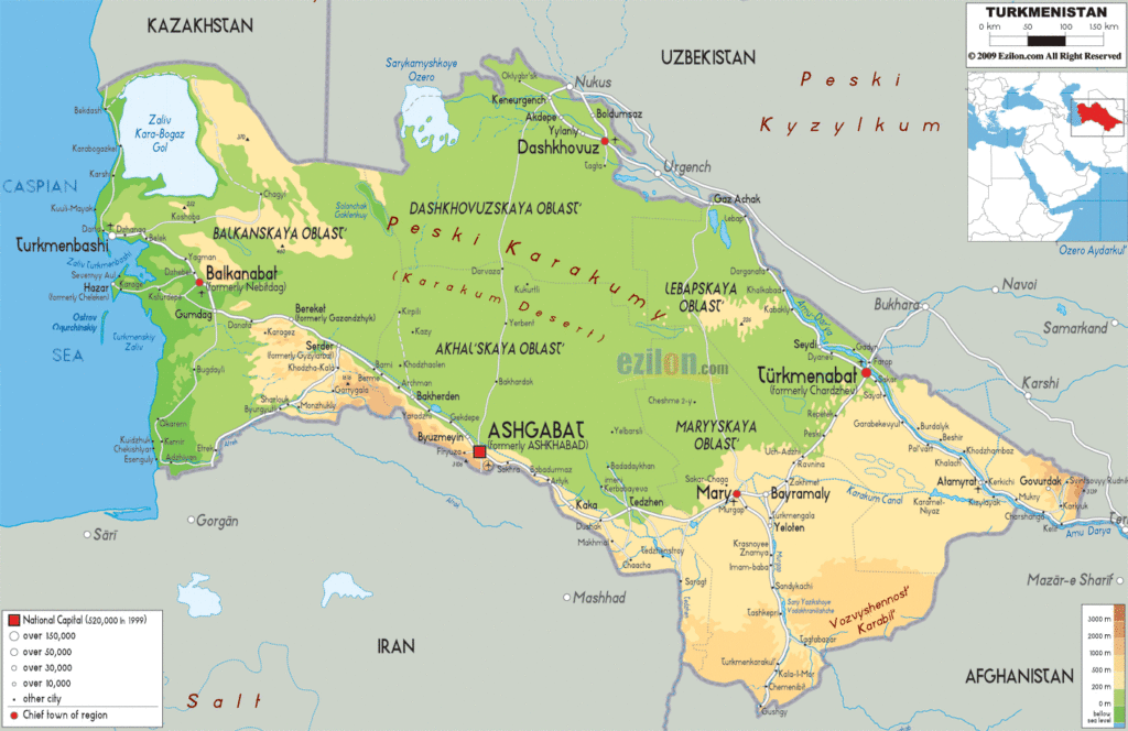
As observed on the physical map of Turkmenistan, most of the topography of the country is dominated by the flat Garagum (or Kara Kum) Desert (north to south), a sandy, scrubby, arid expanse of land, with very little agricultural potential.
The Kopetdag Mountain Range covers its south-central border with Iran, where earthquakes are quite common.
The Pamir Mountain Range extends across its far eastern border – where its highest point is located, Gora Ayribaba which peaks at 3,139 m. An upright triangle marks the position of this highest point on the map.
Along the Caspian Sea and the shorelines of Sarykamish Lake, land elevations below sea level stretch inland for many miles.
The country’s most significant river is the Amu Darya, which flows across and along its border with Uzbekistan. The course of the river in the country can be observed on the map above.
The lowest point of the country is located at the Akjagaýa Depression in the Lake Sarykamish area. It is -81 m below sea-level. An inverted triangle represents this point on the physical map above.
Explore this stunning Turkmenistan reference map and discover the diverse geography of the country. From the Caspian Sea to the vast Kara Kum Desert, the country is full of amazing physical features. See the major cities, towns, roads, lakes, and rivers. Check out the physical map, satellite imagery, and provincial map of Turkmenistan.
Online Interactive Political Map
Click on ![]() to view map in "full screen" mode.
to view map in "full screen" mode.
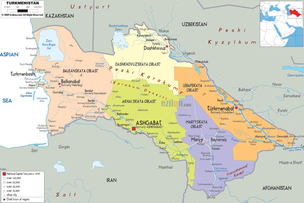
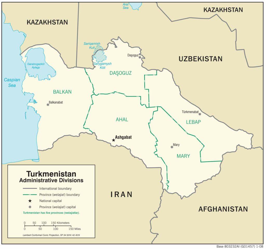
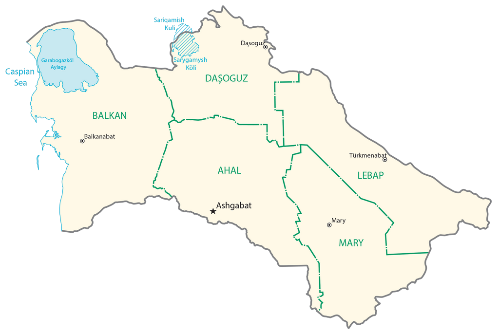
Turkmenistan is divided into 5 administrative regions and one capital city district (Saher). In alphabetical order, these regions are: Ahal, Balkan, Dashoguz, Lebap, and Mary. These regions are further subdivided into districts. The country has a total of 50 districts, 24 towns, 76 villages, 553 rural councils, and 1903 rural settlements.
With an area of 139,300 sq. km, the Balkan Region is the largest region of Afghanistan by area and the Mary Region is the most populous one.
Ashgabat is the capital and the largest city in the country.
Location Maps
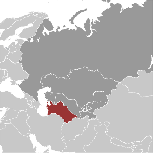
Where is Turkmenistan?
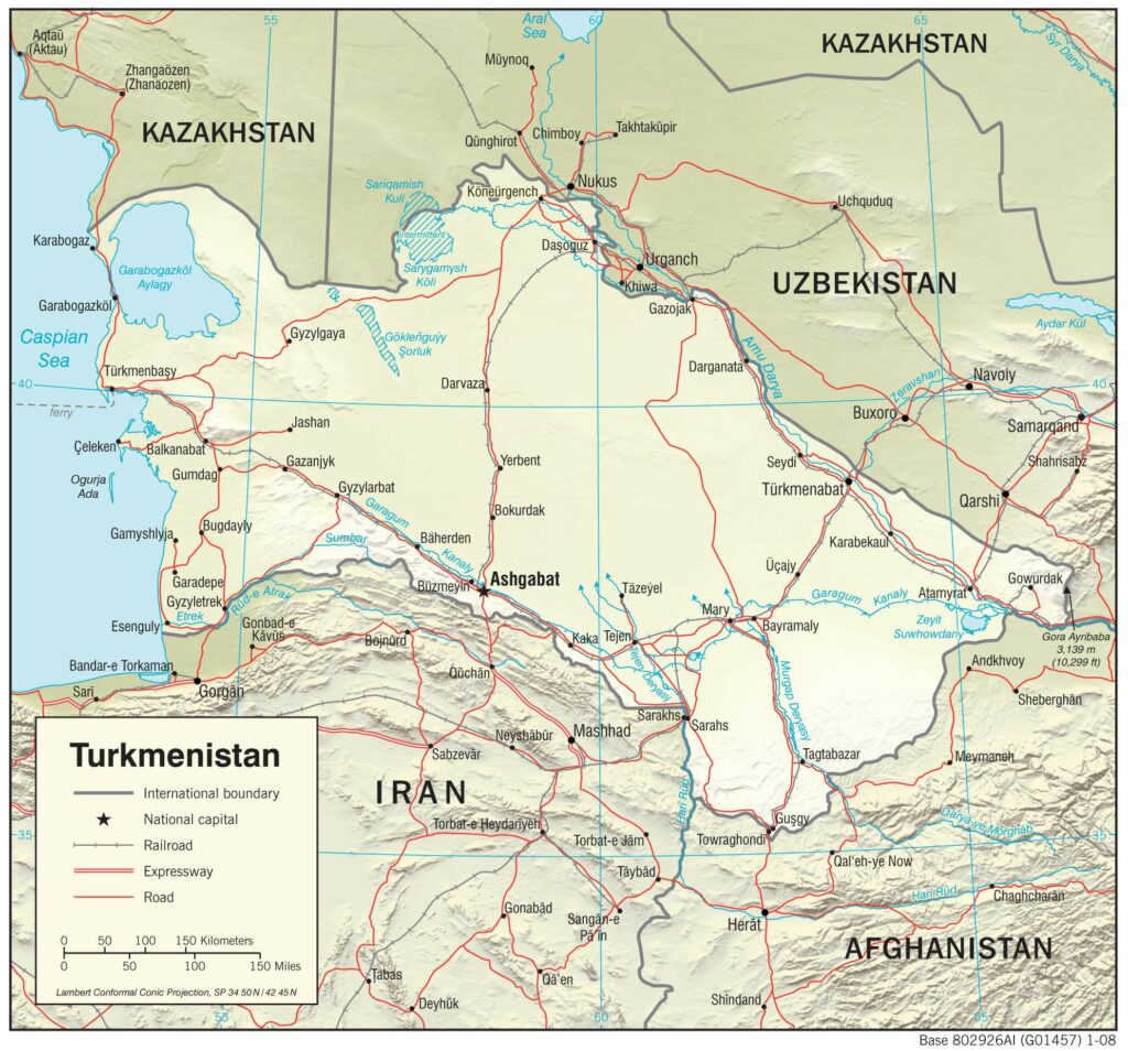
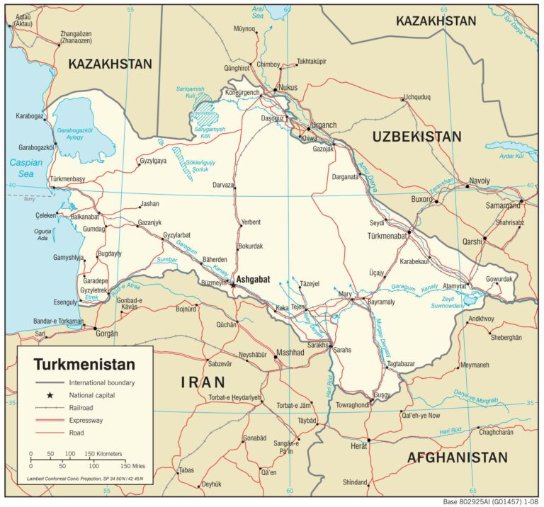
Turkmenistan is located in Central Asia, next to the Caspian Sea, the world’s largest inland body of water. It borders Kazakhstan to the north, Uzbekistan to the northeast, Afghanistan to the southeast, and Iran to the southwest. The coastline of Turkmenistan along the Caspian Sea measures 1,768 kilometers (1,100 mi).
The country is well-known for its gas reserves, underdevelopment, carpets, and horses. Additionally, it is recognized as the “crossroads of civilizations” because the historic silk road runs through Turkmenistan. The capital and largest city is Ashgabat, while the other major cities are Türkmenabat, Daşoguz, and Mary.
High Definition Political Map of Turkmenistan

Turkmenistan Administrative Map
History
Historically inhabited by the Indo-Iranians, the written history of Turkmenistan begins with its annexation by the Achaemenid Empire of Ancient Iran. Later, in the 8th century AD, Turkic-speaking Oghuz tribes moved from Mongolia into present-day Central Asia. Part of a powerful confederation of tribes, these Oghuz formed the ethnic basis of the modern Turkmen population. In the 10th century, the name “Turkmen” was first applied to Oghuz groups that accepted Islam and began to occupy present-day Turkmenistan. There they were under the dominion of the Seljuk Empire, which was composed of Oghuz groups living in present-day Iran and Turkmenistan. Oghuz groups in the service of the empire played an important role in the spreading of Turkic culture when they migrated westward into present-day Azerbaijan and eastern Turkey.
In the 12th century, Turkmen and other tribes overthrew the Seljuk Empire. In the next century, the Mongols took over the more northern lands where the Turkmens had settled, scattering the Turkmens southward and contributing to the formation of new tribal groups. The sixteenth and eighteenth centuries saw a series of splits and confederations among the nomadic Turkmen tribes, who remained staunchly independent and inspired fear in their neighbors. By the 16th century, most of those tribes were under the nominal control of two sedentary Uzbek khanates, Khiva and Bukhoro. Turkmen soldiers were an important element of the Uzbek militaries of this period. In the 19th century, raids and rebellions by the Yomud Turkmen group resulted in that group’s dispersal by the Uzbek rulers. In 1855 the Turkmen tribe of Teke led by Gowshut-Khan defeated the invading army of the Khan of Khiva Muhammad Amin Khan and in 1861 the invading Persian army of Nasreddin-Shah.
In the second half of the 19th century, northern Turkmens were the main military and political power in the Khanate of Khiva. According to Paul R. Spickard, “Prior to the Russian conquest, the Turkmen were known and feared for their involvement in the Central Asian slave trade.”
Russian forces began occupying Turkmen territory late in the 19th century. From their Caspian Sea base at Krasnovodsk (now Türkmenbaşy), the Russians eventually overcame the Uzbek khanates. In 1879, the Russian forces were defeated by the Teke Turkmens during the first attempt to conquer the Ahal area of Turkmenistan. However, in 1881, the last significant resistance in Turkmen territory was crushed at the Battle of Geok Tepe, and shortly thereafter Turkmenistan was annexed, together with adjoining Uzbek territory, into the Russian Empire. In 1916, the Russian Empire’s participation in World War I resonated in Turkmenistan, as an anticonscription revolt swept most of Russian Central Asia. Although the Russian Revolution of 1917 had little direct impact, in the 1920s Turkmen forces joined Kazakhs, Kyrgyz, and Uzbeks in the so-called Basmachi Rebellion against the rule of the newly formed Soviet Union. In 1921 the tsarist province of Transcaspia (Russian: Закаспийская область, ‘Transcaspian Oblast’) was renamed Turkmen Oblast (Russian: Туркменская область), and in 1924, the Turkmen Soviet Socialist Republic was formed from it. By the late 1930s, Soviet reorganization of agriculture had destroyed what remained of the nomadic lifestyle in Turkmenistan, and Moscow controlled political life. The Ashgabat earthquake of 1948 killed over 110,000 people, amounting to two-thirds of the city’s population.
During the next half-century, Turkmenistan played its designated economic role within the Soviet Union and remained outside the course of major world events. Even the major liberalization movement that shook Russia in the late 1980s had little impact. However, in 1990, the Supreme Soviet of Turkmenistan declared sovereignty as a nationalist response to perceived exploitation by Moscow. Although Turkmenistan was ill-prepared for independence and then-communist leader Saparmurat Niyazov preferred to preserve the Soviet Union, in October 1991, the fragmentation of that entity forced him to call a national referendum that approved independence. On 26 December 1991, the Soviet Union ceased to exist. Niyazov continued as Turkmenistan’s chief of state, replacing communism with a unique brand of independent nationalism reinforced by a pervasive cult of personality. A 1994 referendum and legislation in 1999 abolished further requirements for the president to stand for re-election (although in 1992 he completely dominated the only presidential election in which he ran, as he was the only candidate and no one else was allowed to run for the office), making him effectively president for life. During his tenure, Niyazov conducted frequent purges of public officials and abolished organizations deemed threatening. Throughout the post-Soviet era, Turkmenistan has taken a neutral position on almost all international issues. Niyazov eschewed membership in regional organizations such as the Shanghai Cooperation Organisation, and in the late 1990s he maintained relations with the Taliban and its chief opponent in Afghanistan, the Northern Alliance. He offered limited support to the military campaign against the Taliban following the 11 September 2001 attacks. In 2002 an alleged assassination attempt against Niyazov led to a new wave of security restrictions, dismissals of government officials, and restrictions placed on the media. Niyazov accused exiled former foreign minister Boris Shikhmuradov of having planned the attack.
Between 2002 and 2004, serious tension arose between Turkmenistan and Uzbekistan because of bilateral disputes and Niyazov’s implication that Uzbekistan had a role in the 2002 assassination attempt. In 2004, a series of bilateral treaties restored friendly relations. In the parliamentary elections of December 2004 and January 2005, only Niyazov’s party was represented, and no international monitors participated. In 2005, Niyazov exercised his dictatorial power by closing all hospitals outside Ashgabat and all rural libraries. The year 2006 saw intensification of the trends of arbitrary policy changes, shuffling of top officials, diminishing economic output outside the oil and gas sector, and isolation from regional and world organizations. China was among a very few nations to whom Turkmenistan made significant overtures. The sudden death of Niyazov at the end of 2006 left a complete vacuum of power, as his cult of personality, comparable to the one of eternal president Kim Il-sung of North Korea, had precluded the naming of a successor. Deputy Prime Minister Gurbanguly Berdimuhamedow, who was named interim head of government, won a non-democratic special presidential election held in early February 2007. His appointment as interim president and subsequent run for president violated the constitution. Berdimuhamedow won two additional non-democratic elections, with approximately 97% of the vote in both 2012 and 2017. His son Serdar Berdimuhamedow won a non-democratic snap presidential election in 2022, establishing a political dynasty in Turkmenistan. On 19 March 2022, Serdar Berdimuhamedov was sworn in as Turkmenistan’s new president to succeed his father.
Physical Map of Turkmenistan

Geography
At 488,100 km (188,500 sq mi), Turkmenistan is the world’s 52nd-largest country. It is slightly smaller than Spain and larger than Cameroon. It lies between latitudes 35° and 43° N, and longitudes 52° and 67° E. Over 80% of the country is covered by the Karakum Desert. The center of the country is dominated by the Turan Depression and the Karakum Desert. Topographically, Turkmenistan is bounded by the Ustyurt Plateau to the north, the Kopet Dag Range to the south, the Paropamyz Plateau, the Koytendag Range to the east, the Amu Darya Valley, and the Caspian Sea to the west. Turkmenistan includes three tectonic regions, the Epigersin platform region, the Alpine shrinkage region, and the Epiplatform orogenesis region. The Alpine tectonic region is the epicenter of earthquakes in Turkmenistan. Strong earthquakes occurred in the Kopet Dag Range in 1869, 1893, 1895, 1929, 1948, and 1994. The city of Ashgabat and surrounding villages were largely destroyed by the 1948 earthquake.
The Kopet Dag Range, along the southwestern border, reaches 2,912 metres (9,554 feet) at Kuh-e Rizeh (Mount Rizeh).
The Great Balkhan Range in the west of the country (Balkan Province) and the Köýtendag Range on the southeastern border with Uzbekistan (Lebap Province) are the only other significant elevations. The Great Balkhan Range rises to 1,880 metres (6,170 ft) at Mount Arlan and the highest summit in Turkmenistan is Ayrybaba in the Kugitangtau Range – 3,137 metres (10,292 ft). The Kopet Dag mountain range forms most of the border between Turkmenistan and Iran.
Major rivers include the Amu Darya, the Murghab River, the Tejen River, and the Atrek (Etrek) River. Tributaries of the Atrek include the Sumbar River and Chandyr River.
The Turkmen shore along the Caspian Sea is 1,748 kilometres (1,086 mi) long. The Caspian Sea is entirely landlocked, with no natural access to the ocean, although the Volga–Don Canal allows shipping access to and from the Black Sea.
Major cities include Aşgabat, Türkmenbaşy (formerly Krasnovodsk), Balkanabat, Daşoguz, Türkmenabat, and Mary.
Climate, biodiversity and environment
Turkmenistan is in a temperate desert zone with a dry continental climate. Remote from the open sea, with mountain ranges to the south and southeast, Turkmenistan’s climate is characterized by low precipitation, low cloudiness, and high evaporation. Absence of mountains to the north allows cold Arctic air to penetrate southward to the southerly mountain ranges, which in turn block warm, moist air from the Indian Ocean. Limited winter and spring rains are attributable to moist air from the west, originating in the Atlantic Ocean and Mediterranean Sea. Winters are mild and dry, with most precipitation falling between January and May. The Kopet Dag Range receives the highest level of precipitation.
The Karakum Desert is one of the driest deserts in the world; some places have an average annual precipitation of only 12 mm (0.47 in). The highest temperature recorded in Ashgabat is 48.0 °C (118.4 °F) and Kerki, an extreme inland city located on the banks of the Amu Darya river, recorded 51.7 °C (125.1 °F) in July 1983, although this value is unofficial. 50.1 °C (122 °F) is the highest temperature recorded at Repetek Reserve, recognized as the highest temperature ever recorded in the whole former Soviet Union. Turkmenistan enjoys 235–240 sunny days per year. The average number of degree days ranges from 4500 to 5000 Celsius, sufficient for production of extra long staple cotton.
Turkmenistan contains seven terrestrial ecoregions: Alai-Western Tian Shan steppe, Kopet Dag woodlands and forest steppe, Badghyz and Karabil semi-desert, Caspian lowland desert, Central Asian riparian woodlands, Central Asian southern desert, and Kopet Dag semi-desert.
Turkmenistan’s greenhouse gas emissions per person (17.5 tCO2e) are considerably higher than the OECD average: due mainly to natural gas seepage from oil and gas exploration.
Administrative divisions
Turkmenistan is divided into five provinces or welayatlar (singular welayat) and one capital city district. The provinces are subdivided into districts (etraplar, sing. etrap), which may be either counties or cities. According to the Constitution of Turkmenistan (Article 16 in the 2008 Constitution, Article 47 in the 1992 Constitution), some cities may have the status of welaýat (province) or etrap (district).
