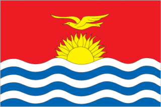
Covering a total land area of 811 sq.km (313 sq mi), the widely scattered nation of Kiribati comprises of 32 atolls and one raised coral island (Banaba), spread over 3.5 million sq.km at the heart of the Pacific Ocean. These low-lying coral atolls are the protruding tips of undersea volcanoes and extend only a few feet above sea level, being surrounded by extensive reefs.
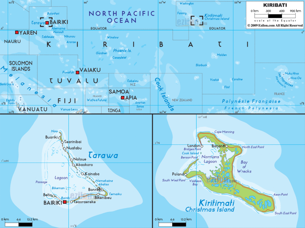
As observed on the physical map of Kiribati above, the islands are grouped into the Gilbert Islands in the west; the Phoenix Islands in the center and the Line Islands in the east. Except for the Banaba island, most of the islands and atolls have ring-shaped islands with central lagoons. One of the world’s largest coral atoll is Kiritimati (Christmas Islands) situated in the Line group and having a land area of 388 sq.km, accounting for about half of the total land area of the country. The raised limestone Banaba island at an elevation of 285ft (87m) is the highest point in Kiribati. Coconut palms are found dominating the landscape on each island.
Kiribati is an island nation located in the Pacific Ocean, consisting of 33 atolls and islands. Its three main islands are the Gilbert Islands, Line Islands, and the Phoenix Islands, which are all part of the archipelago. These islands are home to many populated places, such as Abaiang, Marakei, and Butaritari. The map of Kiribati displays the various locations of the atolls and islands, as well as the populated places that are known as Kiribati.
Location Maps
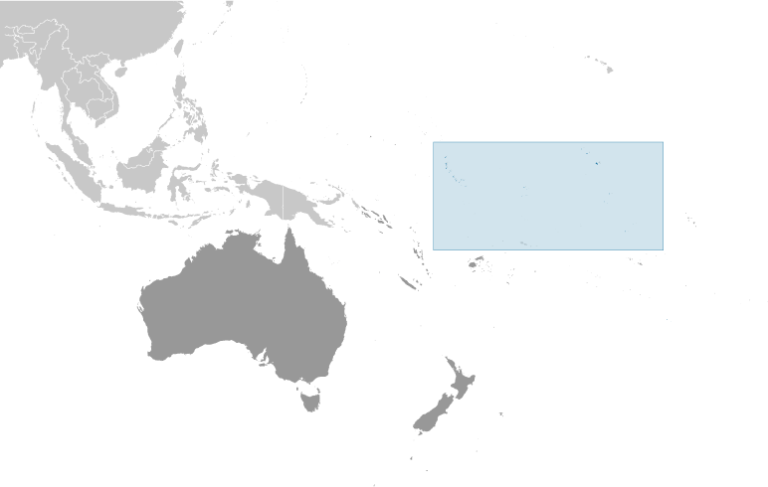
Where is Kiribati?
Kiribati is an island nation situated in the Pacific Ocean, close to the equator and the International Date Line. It is only 2,950 kilometers from Hawaii, as well as near the Marshall Islands and the Cook Islands. This country has a total land area of 811 square kilometers and a population of approximately 120,000 people, the majority of whom reside in the capital city of Tarawa, located to the west.
Kiribati is unique in that it is spread across four hemispheres and its largest coral atoll is the largest in the world. As it is located at the International Date Line, it is the first country in the world to bring in the new year.
High Definition Political Map of Kiribati
History
Early history
The area now called Kiribati, mainly the 16 Gilbert Islands, has been inhabited by Austronesian peoples speaking the same Oceanic language, from north to south, including the southernmost Nui, since sometime between 3000 BCE and 1300 CE. The area was not completely isolated; later, voyagers from Samoa, Tonga, and Fiji introduced some Polynesian and Melanesian cultural aspects, respectively. Intermarriage and intense navigation between the islands tended to blur cultural differences and resulted in a significant degree of cultural homogenization. Local oral historians chiefly in the form of lore keepers suggest that the area was first inhabited by a group of seafaring people from Melanesia, who were described as being dark-skinned, frizzy-haired, and short in stature. These indigenous peoples were then visited by early Austronesian seafarers from the west, a place called Matang, orally described as being tall and fair-skinned. Eventually, both groups intermittently clashed and intermingled until they slowly became a uniform population.
Around 1300 CE, a mass exodus occurred from Samoa at the same time that cannibalism was forcefully abolished there, leading to the addition of Polynesian ancestry into the mix of most Gilbertese people. These Samoans later brought strong features of Polynesian languages and culture, creating clans based on their own Samoan traditions and slowly intertwining with the indigenous clans and powers already dominant in Kiribati. Around the 15th century, starkly contrasting systems of governance arose between the northern islands, primarily under chiefly rule (uea), and the central and southern islands, primarily under the rule of their council of elders (unimwaane). Tabiteuea could be an exception as the sole island that is known as maintaining a traditional egalitarian society. The name Tabiteuea stems from the root phrase Tabu-te-Uea, meaning “chiefs are forbidden”. Civil war soon became a factor, with acquisition of land being the main form of conquest. Clans and chiefs began fighting over resources, fueled by hatred and reignited blood feuds, which may have started months, years, or even decades before.
The turmoil lasted well into the European visitation and colonial era, which led to certain islands decimating their foes with the help of guns and cannon-equipped ships that some Europeans were coerced into using by the more cunning and persuasive among the I-Kiribati leaders. The typical military arms of the I-Kiribati at this time were shark tooth-embedded wooden spears, knives, and swords, and garbs of armour fashioned from dense coconut fibre. They chiefly used these instead of the gunpowder and weapons of steel available at the time, because of the strong sentimental value of the equipment handed down through generations. Ranged weapons, such as bows, slings, and javelins, were seldom used; hand-to-hand combat was a prominent skill still practised today, though seldom mentioned because of various taboos associated with it, secrecy being the primary one. Abemama’s High Chief Tembinok’ was the last of the dozens of expansionist chiefs of Gilbert Islands of this period, despite Abemama historically conforming to the traditional southern islands’ governance of their respective unimwaane. He was immortalised in Robert Louis Stevenson’s book In the South Seas, which delved into the high chief’s character and method of rule during Stevenson’s stay in Abemama. The 90th anniversary of his arrival in the Gilbert Islands was chosen to celebrate the independence of Kiribati on 12 July 1979.
Colonial era
Chance visits by European ships occurred in the 17th and 18th centuries, while those ships attempted circumnavigations of the world, or sought sailing routes from the south to north Pacific Ocean. A passing trade, whaling the On-The-Line grounds, and labour ships associated with blackbirding of Kanakas workers, visited the islands in large numbers during the 19th century, with social, economic, political, religious and cultural consequences. More than 9,000 workers were sent abroad from 1845 to 1895, most of them not returning.
The passing trade gave rise to European, Chinese, Samoan, and other residents from the 1830s; they included beachcombers, castaways, traders, and missionaries.
In 1886, an Anglo-German agreement partitioned the “unclaimed” central Pacific, leaving Nauru in the German sphere of influence, while Ocean Island and the future GEIC wound up in the British sphere of influence. In 1892, local Gilbertese authorities (an uea, a chief from the Northern Gilbert Group, and atun te boti or head of clan) on each of the Gilbert Islands agreed to Captain E.H.M. Davis commanding HMS Royalist of the Royal Navy declaring them part of a British protectorate, along with the nearby Ellice Islands. They were administered by a resident commissioner based first on Makin Islands (1893–95), then in Betio, Tarawa (1896–1908) and Ocean Island (1908–1942), protectorate who was under the Western Pacific High Commission based in Fiji. Banaba, known to Europeans as Ocean Island, was added to the protectorate in 1900, because of the phosphate rock of its soil (discovered in 1900). This discovery and the mining ended the contracting of Kanakas workers to farm plantations in Queensland, German Samoa or Central America, with all the needed workers being used in Ocean Island extraction.
The conduct of William Telfer Campbell, the second resident commissioner of the Gilberts and Ellice Islands of 1896 to 1908, was criticised as to his legislative, judicial and administrative management (including allegations of forced labour exacted from islanders) and became the subject of the 1909 report by Arthur Mahaffy. In 1913, an anonymous correspondent to The New Age newspaper described the maladministration of W. Telfer Campbell and questioned the partiality of Arthur Mahaffy, because he was a former colonial official in the Gilberts. The anonymous correspondent also criticised the operations of the Pacific Phosphate Company on Ocean Island.
The islands became the crown colony of the Gilbert and Ellice Islands in 1916. The Northern Line Islands, including Christmas Island (Kiritimati), were added to the colony in 1919, and the Phoenix Islands were added in 1937 with the purpose of a Phoenix Islands Settlement Scheme. On 12 July 1940, Pan Am Airways’ American Clipper landed at Canton Island for the first time during a flight from Honolulu to Auckland.
Sir Arthur Grimble was a cadet administrative officer based at Tarawa (1913–1919) and became Resident Commissioner of the Gilbert and Ellice Islands colony in 1926.
In 1902, the Pacific Cable Board laid the first trans-Pacific telegraph cable from Bamfield, British Columbia to Fanning Island (Tabuaeran) in the Line Islands, and from Fiji to Fanning Island, thus completing the All Red Line, a series of telegraph lines circumnavigating the globe completely within the British Empire. The location of Fanning Island, one of the closest formations to Hawaii, led to its annexation by the British Empire in 1888. Nearby candidates including Palmyra Island were not favoured due to the lack of adequate landing sites.
The United States eventually incorporated the Northern Line Islands into its territories, and did the same with the Phoenix Islands, which lie between Gilberts and the Line Islands, including Howland, Jarvis, and Baker islands, thus causing a territorial dispute. That was eventually resolved and they finally became part of Kiribati under the Treaty of Tarawa.
After the attack on Pearl Harbor, during World War II, Butaritari and Tarawa, and others of the Northern Gilbert group, were occupied by Japan from 1941 to 1943. Betio became an airfield and supply base. The expulsion of the Japanese military in late 1943 involved one of the bloodiest battles in US Marine Corps history. Marines landed in November 1943 and the Battle of Tarawa ensued. Ocean Island, the headquarters of the colony, was bombed, evacuated and occupied by Japan in 1942 and only freed in 1945, after the massacre of all but one of the Gilbertese on the island by the Japanese forces. Funafuti hosted then the provisional headquarters of the colony from 1942 to 1946, when Tarawa returned to host the headquarters, replacing Ocean Island.
At the end of 1945, most of the remaining inhabitants of Banaba, repatriated from Kosrae, Nauru and Tarawa, were relocated to Rabi Island, a land of Fiji that the British government had acquired in 1942 for this purpose.
On 1 January 1953, the British Western Pacific High Commissioner of the colony was transferred from Fiji to the new capital of Honiara, to the British Solomon Islands, with the Gilberts’ Resident Commissioner still headquartered in Tarawa.
Further military operations in the colony occurred in the late 1950s and early 1960s when Christmas Island was used by the United States and United Kingdom for nuclear weapons testing including hydrogen bombs.
Institutions of internal self-rule were established on Tarawa from about 1967. The Ellice Islands asked for separation from the rest of the colony in 1974 and granted their own internal self-rule institutions. The separation entered into force on 1 January 1976. In 1978, the Ellice Islands became the independent nation of Tuvalu.
Independence
The Gilbert Islands gained independence as the Republic of Kiribati on 12 July 1979. Then, in September, the United States relinquished all claims to the sparsely inhabited Phoenix and Line Islands, in a 1979 treaty of friendship with Kiribati (ratified in 1983). Although the indigenous Gilbertese name for the Gilbert Islands proper is “Tungaru”, the new state chose the name “Kiribati”, the Gilbertese spelling of “Gilberts”, because it was more modern and as an equivalent of the former colony to acknowledge the inclusion of Banaba, the Line Islands, and the Phoenix Islands. The last two archipelagoes were never initially occupied by Gilbertese until the British authorities, and later the Republic Government, resettled Gilbertese there under resettlement schemes. In 1982, the first elections since independence were held. A no confidence vote provoked the 1983 new election. In the post-independence era, overcrowding has been an issue, at least in British and aid organisations’ eyes. In 1988, an announcement was made that 4,700 residents of the main island group would be resettled onto less-populated islands. In September 1994, Teburoro Tito from the opposition was elected president.
In 1995, Kiribati unilaterally moved the international date line far to the east to encompass the Line Islands group, so that the nation would no longer be divided by the date line. The move, which fulfilled one of President Tito’s campaign promises, was intended to allow businesses across the expansive nation to keep the same business week. This also enabled Kiribati to become the first country to see the dawn of the third millennium, an event of significance for tourism. Tito was re-elected in 1998. In 1999, Kiribati became a full member of the United Nations, 20 years after independence. In 2002, Kiribati passed a controversial law that enabled the government to shut down newspaper publishers. The legislation followed the launching of Kiribati’s first successful non-government-run newspaper. President Tito was re-elected in 2003 but was removed from office in March 2003 by a no-confidence vote and replaced by a Council of State. Anote Tong of the opposition party Boutokaan Te Koaua was elected to succeed Tito in July 2003. He was re-elected in 2007 and in 2011.
In June 2008, Kiribati officials asked Australia and New Zealand to accept Kiribati citizens as permanent refugees. Kiribati is expected to be the first country to lose all its land territory to climate change. In June 2008, the Kiribati President Anote Tong said that the country had reached “the point of no return.” He added, “To plan for the day when you no longer have a country is indeed painful but I think we have to do that.”
In January 2012, Anote Tong was re-elected for a third and last successive term. In early 2012, the government of Kiribati purchased the 2,200-hectare Natoavatu Estate on the second largest island of Fiji, Vanua Levu. At the time it was widely reported that the government planned to evacuate the entire population of Kiribati to Fiji. In April 2013, President Tong began urging citizens to evacuate the islands and migrate elsewhere. In May 2014, the Office of the President confirmed the purchase of some 5,460 acres of land on Vanua Levu at a cost of 9.3 million Australian dollars.
In March 2016, Taneti Maamau was elected as the new President of Kiribati. He was the fifth president since the country became independent in 1979. In June 2020, President Maamau won re-election for second four-year term. President Maamau was considered pro-China and he supported closer ties with Beijing. On 16 November 2021, the Kiribati government announced it would expand the world’s largest marine protected area to economic benefits of commercial fishing. The 2022 Kiribati constitutional crisis started with the suspension of all 5 major Justices of the judiciary of Kiribati.


