North Korea covers an area of 120,540 sq. km in the northern half of the Korean Peninsula.
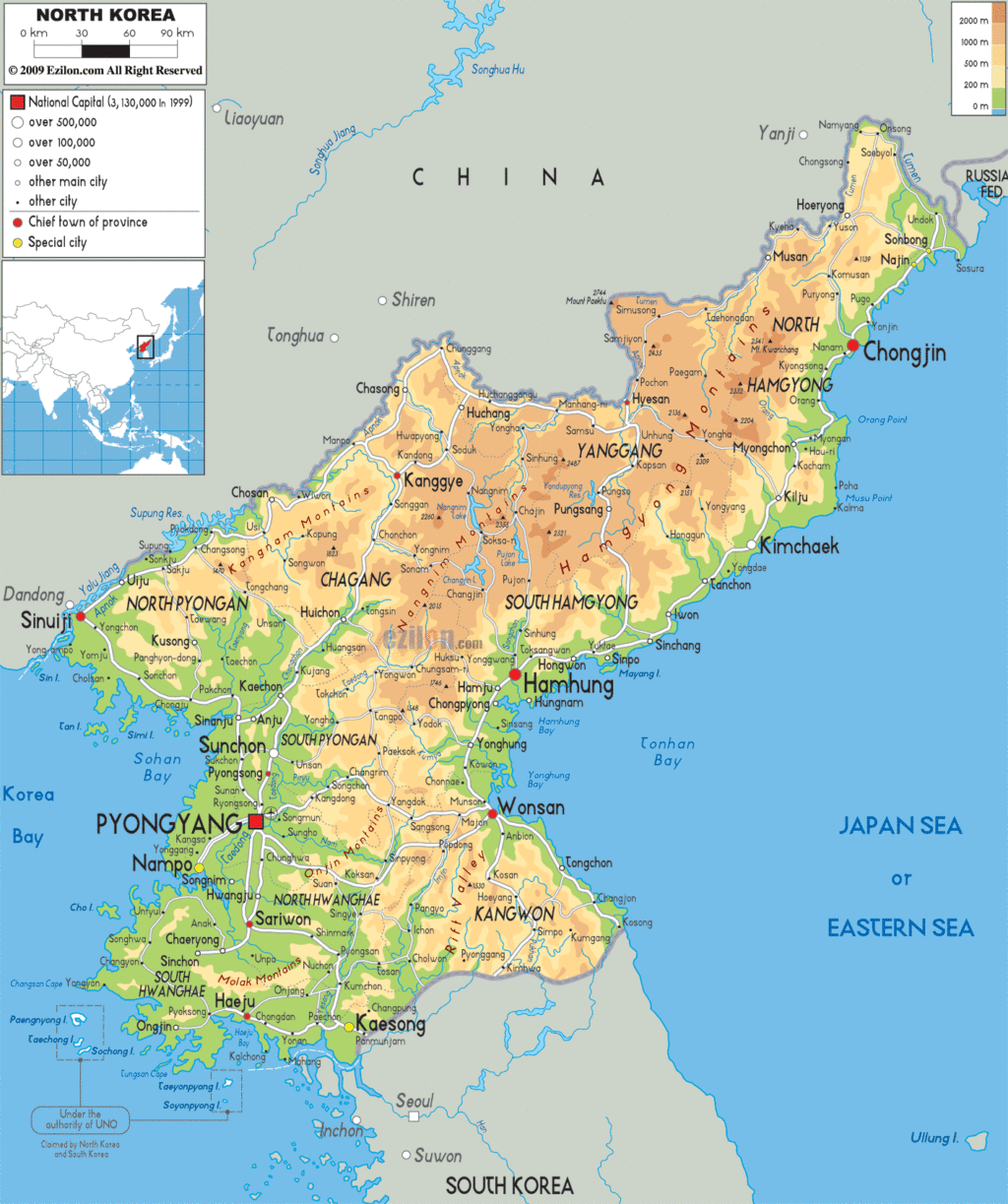
As observed on the physical map of North Korea above, the country is very mountainous. Several mountain ranges and uplands area crisscross the country separated by deep narrow valleys.
As marked on the map by a yellow upright triangle, the highest peak, Paektu-san on the volcanic Baekdu Mountain, is located on its northern border with China, and rises 9,002 ft. (2,744 m). Important mountains found in the country include the Hamgyong, Rangrim, and Kangnam Ranges.
Along the west coast there are wide coastal plains, while along the Sea of Japan (East Sea) coastline (North Korea’s lowest point at 0 m), narrow plains rise into mountains. Similar to South Korea, dozens of small islands dot the western coastline.
North Korea’s longest river is the Yulu (Yalu). Other large rivers include the Tumen, Taedang, and Imjin.
The lowest point in North Korea is the Sea of Japan at sea level.
Explore the fascinating geography of the Democratic People’s Republic of Korea with this detailed map. Discover its cities, towns, highways, roads, lakes, and rivers, as well as satellite imagery and an elevation map.
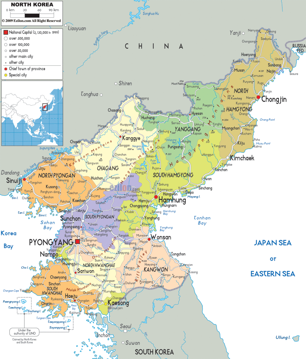
Online Interactive Political Map
Click on ![]() to view map in "full screen" mode.
to view map in "full screen" mode.
North Korea (officially, Democratic People’s Republic of Korea) is divided into 9 administrative provinces and 3 cities. In alphabetical order, these provinces are: Chagang, Hambuk (North Hamgyong), Hamnam (South Hamgyong), Hwangbuk (North Hwanghae), Hwangnam (South Hwanghae), Kangwon, P’yongbuk (North Pyongan), P’yongnam (South Pyongan) and Ryanggang. The cities are: Namp’o, P’yongyang and Rason. These administrative divisions are further subdivided into a number of smaller subdivisions.
Located in the west-central part of North Korea along the banks of the Taedong River is P’yongyang – the capital and largest city of North Korea.
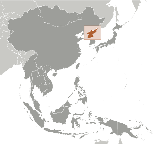
Location Maps
Where is North Korea?
North Korea: An Isolated Country Tightly Controlled by Totalitarian Leaders
North Korea, also known as the Democratic People’s Republic of Korea (DPRK), is a country located in Eastern Asia, along the East Sea (Sea of Japan). It is an isolated country and is tightly controlled by its totalitarian leaders. It borders both China and Russia to the north, and is separated from South Korea to the south by a 250-kilometer-long Demilitarized Zone (DMZ) that crosses the 38th parallel.
The capital and largest city of North Korea is Pyongyang, with other major cities including Hamhung, Namp’o, and Sunch’ŏn.
High Definition Political Map of North Korea

History
Founding
After the First Sino-Japanese War and the Russo-Japanese War, Korea was ruled by Japan from 1910 to 1945. Korean resistance groups known as Dongnipgun (Liberation Army) operated along the Sino-Korean border, fighting guerrilla warfare against Japanese forces. Some of them took part in allied action in China and parts of South East Asia. One of the guerrilla leaders was the communist Kim Il-sung, who later became the first leader of North Korea.
After the Japanese surrender at the end of World War II in 1945, the Korean Peninsula was divided into two zones along the 38th parallel, with the northern half of the peninsula occupied by the Soviet Union and the southern half by the United States. Negotiations on reunification failed. Soviet general Terentii Shtykov recommended the establishment of the Soviet Civil Authority in October 1945, and supported Kim Il-sung as chairman of the Provisional People’s Committee for North Korea, established in February 1946. In September 1946, South Korean citizens rose up against the Allied Military Government. In April 1948, an uprising of the Jeju islanders was violently crushed. The South declared its statehood in May 1948 and two months later the ardent anti-communist Syngman Rhee became its ruler. The Democratic People’s Republic of Korea was established in the North on 9 September 1948. Shtykov served as the first Soviet ambassador, while Kim Il-sung became premier.
Soviet forces withdrew from the North in 1948, and most American forces withdrew from the South in 1949. Ambassador Shtykov suspected Rhee was planning to invade the North and was sympathetic to Kim’s goal of Korean unification under socialism. The two successfully lobbied Joseph Stalin to support a quick war against the South, which culminated in the outbreak of the Korean War.
Korean War
The military of North Korea invaded the South on 25 June 1950, and swiftly overran most of the country. The United Nations Command (UNC) was subsequently established following the UN Security Council’s recognition of North Korean aggression against South Korea. The motion passed because the Soviet Union, a close ally of North Korea and a member of the UN Security Council, was boycotting the UN over its recognition of the Republic of China rather than the People’s Republic of China. The UNC, led by the United States, intervened to defend the South, and rapidly advanced into North Korea. As they neared the border with China, Chinese forces intervened on behalf of North Korea, shifting the balance of the war again. Fighting ended on 27 July 1953, with an armistice that approximately restored the original boundaries between North and South Korea, but no peace treaty was signed. Approximately 3 million people died in the Korean War, with a higher proportional civilian death toll than World War II or the Vietnam War. In both per capita and absolute terms, North Korea was the country most devastated by the war, which resulted in the death of an estimated 12–15% of the North Korean population (c. 10 million), “a figure close to or surpassing the proportion of Soviet citizens killed in World War II,” according to Charles K. Armstrong. As a result of the war, almost every substantial building in North Korea was destroyed. Some have referred to the conflict as a civil war, with other factors involved.
A heavily guarded demilitarized zone (DMZ) still divides the peninsula, and an anti-communist and anti-North Korea sentiment remains in South Korea. Since the war, the United States has maintained a strong military presence in the South which is depicted by the North Korean government as an imperialist occupation force. It claims that the Korean War was caused by the United States and South Korea.
Post-war developments
The post-war 1950s and 1960s saw an ideologicial shift in North Korea, as Kim Il-sung sought to consolidate his power. Kim Il-sung was highly critical of Soviet premier Nikita Khrushchev and his de-Stalinization policies, and echoed Chinese critiques of Khrushchev as “revisionist”. During the 1956 August Faction Incident, Kim Il-sung successfully resisted efforts by the Soviet Union and China to depose him in favor of Soviet Koreans or the pro-Chinese Yan’an faction. Some scholars believe that the 1956 August incident was an example of North Korea demonstrating political independence. However, most scholars consider the final withdrawal of Chinese troops from North Korea in October 1958 to be the latest date when North Korea became effectively independent. In the late 1950s and early 1960s, North Korea sought to distinguish itself internationally by becoming a leader of the Non-Aligned Movement and promoting the ideology of Juche. In United States policymaking, North Korea was considered among the Captive Nations. Despite its efforts to break out of the Soviet and Chinese spheres of influence, North Korea remained closely aligned with both countries throughout the Cold War.
Industry was the favored sector in North Korea. Industrial production returned to pre-war levels by 1957. In 1959, relations with Japan had improved somewhat, and North Korea began allowing the repatriation of Japanese citizens in the country. The same year, North Korea revalued the North Korean won, which held greater value than its South Korean counterpart. Until the 1960s, economic growth was higher than in South Korea, and North Korean GDP per capita was equal to that of its southern neighbor as late as 1976. However, by the 1980s, the economy had begun to stagnate; it started its long decline in 1987 and almost completely collapsed after the dissolution of the Soviet Union in 1991, when all Soviet aid was suddenly halted.
An internal CIA study acknowledged various achievements of the North Korean government post-war: compassionate care for war orphans and children in general, a radical improvement in the status of women, free housing, free healthcare, and health statistics particularly in life expectancy and infant mortality that were comparable to even the most advanced nations up until the North Korean famine. Life expectancy in the North was 72 before the famine which was only marginally lower than in the South. The country once boasted a comparatively developed healthcare system; pre-famine North Korea had a network of nearly 45,000 family practitioners with some 800 hospitals and 1,000 clinics.
The relative peace between the North and South following the armistice was interrupted by border skirmishes, celebrity abductions, and assassination attempts. The North failed in several assassination attempts on South Korean leaders, such as in 1968, 1974, and the Rangoon bombing in 1983; tunnels were found under the DMZ and tensions flared over the axe murder incident at Panmunjom in 1976. For almost two decades after the war, the two states did not seek to negotiate with one another. In 1971, secret, high-level contacts began to be conducted culminating in the 1972 July 4th North–South Joint Statement that established principles of working toward peaceful reunification. The talks ultimately failed because in 1973, South Korea declared its preference that the two Koreas should seek separate memberships in international organizations.
Post Cold War
In 1992, as Kim Il-sung’s health began deteriorating, Kim Jong-il slowly began taking over various state tasks. Kim Il-sung died of a heart attack in 1994, with Kim Jong-il declaring a three-year period of national mourning before officially announcing his position as the new leader afterwards.
North Korea promised to halt its development of nuclear weapons under the Agreed Framework, negotiated with U.S. president Bill Clinton and signed in 1994. Building on Nordpolitik, South Korea began to engage with the North as part of its Sunshine Policy. Kim Jong-il instituted a policy called Songun, or “military first”.
Flooding in the mid-1990s exacerbated the economic crisis, severely damaging crops and infrastructure and led to widespread famine which the government proved incapable of curtailing, resulting in the deaths of between 240,000 and 420,000 people. In 1996, the government accepted UN food aid.
21st century
The international environment changed once George W. Bush became U.S. President in 2001. His administration rejected South Korea’s Sunshine Policy and the Agreed Framework. Bush included North Korea in his axis of evil in his 2002 State of the Union address. The U.S. government accordingly treated North Korea as a rogue state, while North Korea redoubled its efforts to acquire nuclear weapons. On 9 October 2006, North Korea announced it had conducted its first nuclear weapons test.
U.S. President Barack Obama adopted a policy of “strategic patience”, resisting making deals with North Korea. Tensions with South Korea and the United States increased in 2010 with the sinking of the South Korean warship Cheonan and North Korea’s shelling of Yeonpyeong Island.
On 17 December 2011, Kim Jong-il died from a heart attack. His youngest son Kim Jong-un was announced as his successor. In the face of international condemnation, North Korea continued to develop its nuclear arsenal, possibly including a hydrogen bomb and a missile capable of reaching the United States.
Throughout 2017, following Donald Trump’s ascension to the US presidency, tensions between the United States and North Korea increased, and there was heightened rhetoric between the two, with Trump threatening “fire and fury” if North Korea ever attacked U.S. territory amid North Korean threats to test missiles that would land near Guam. The tensions substantially decreased in 2018, and a détente developed. A series of summits took place between Kim Jong-un of North Korea, President Moon Jae-in of South Korea, and President Trump.
On 10 January 2021, Kim Jong-un was formally elected as the General Secretary in 8th Congress of the Workers’ Party of Korea, a title previously held by Kim Jong-il. On 24 March 2022, North Korea conducted a successful ICBM test launch for the first time since the 2017 crisis. In September 2022, North Korea passed a law that declared itself a nuclear state.
Physical Map of North Korea

Geography
North Korea occupies the northern portion of the Korean Peninsula, lying between latitudes 37° and 43°N, and longitudes 124° and 131°E. It covers an area of 120,540 square kilometers (46,541 sq mi). To its west are the Yellow Sea and Korea Bay, and to its east lies Japan across the Sea of Japan.
Early European visitors to Korea remarked that the country resembled “a sea in a heavy gale” because of the many successive mountain ranges that crisscross the peninsula. Some 80 percent of North Korea is composed of mountains and uplands, separated by deep and narrow valleys. All of the Korean Peninsula’s mountains with elevations of 2,000 meters (6,600 ft) or more are located in North Korea. The highest point in North Korea is Paektu Mountain, a volcanic mountain with an elevation of 2,744 meters (9,003 ft) above sea level. Considered a sacred place by North Koreans, Mount Paektu holds significance in Korean culture and has been incorporated in the elaborate folklore and personality cult around the Kim family. For example, the song, “We Will Go To Mount Paektu” sings in praise of Kim Jong-un and describes a symbolic trek to the mountain. Other prominent ranges are the Hamgyong Range in the extreme northeast and the Rangrim Mountains, which are located in the north-central part of North Korea. Mount Kumgang in the Taebaek Range, which extends into South Korea, is famous for its scenic beauty.
The coastal plains are wide in the west and discontinuous in the east. A great majority of the population lives in the plains and lowlands. According to a United Nations Environmental Programme report in 2003, forest covers over 70 percent of the country, mostly on steep slopes. North Korea had a 2019 Forest Landscape Integrity Index mean score of 8.02/10, ranking it 28th globally out of 172 countries. The longest river is the Amnok (Yalu) River which flows for 790 kilometers (491 mi). The country contains three terrestrial ecoregions: Central Korean deciduous forests, Changbai Mountains mixed forests, and Manchurian mixed forests.
Climate
North Korea experiences a combination of continental climate and an oceanic climate, but most of the country experiences a humid continental climate within the Köppen climate classification scheme. Winters bring clear weather interspersed with snow storms as a result of northern and northwestern winds that blow from Siberia. Summer tends to be by far the hottest, most humid, and rainiest time of year because of the southern and southeastern monsoon winds that carry moist air from the Pacific Ocean. Approximately 60 percent of all precipitation occurs from June to September. Spring and autumn are transitional seasons between summer and winter. The daily average high and low temperatures for Pyongyang are −3 and −13 °C (27 and 9 °F) in January and 29 and 20 °C (84 and 68 °F) in August.


