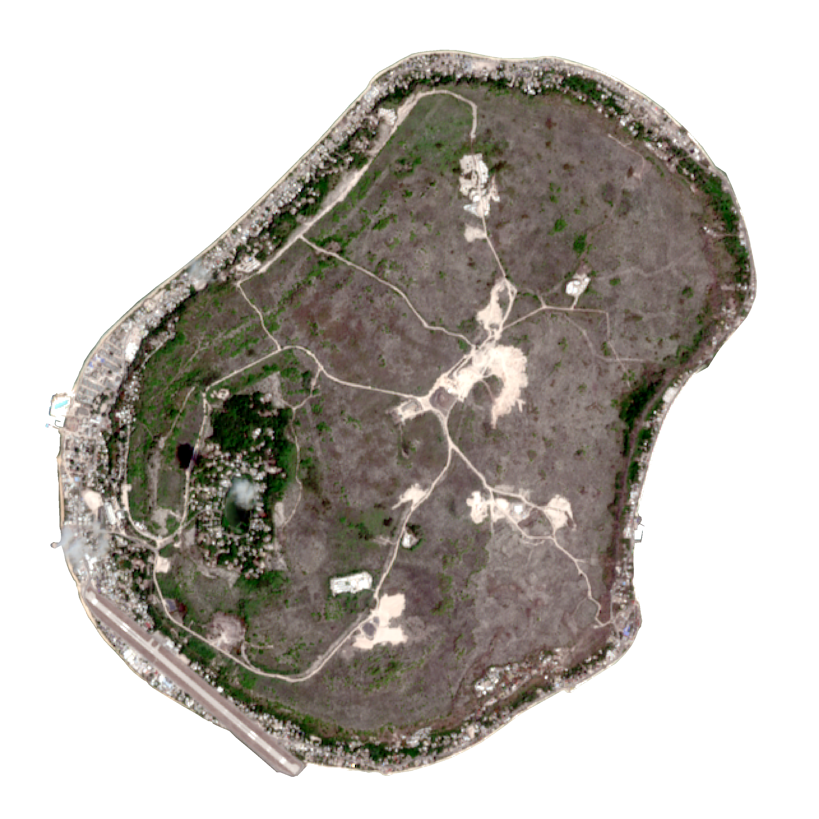
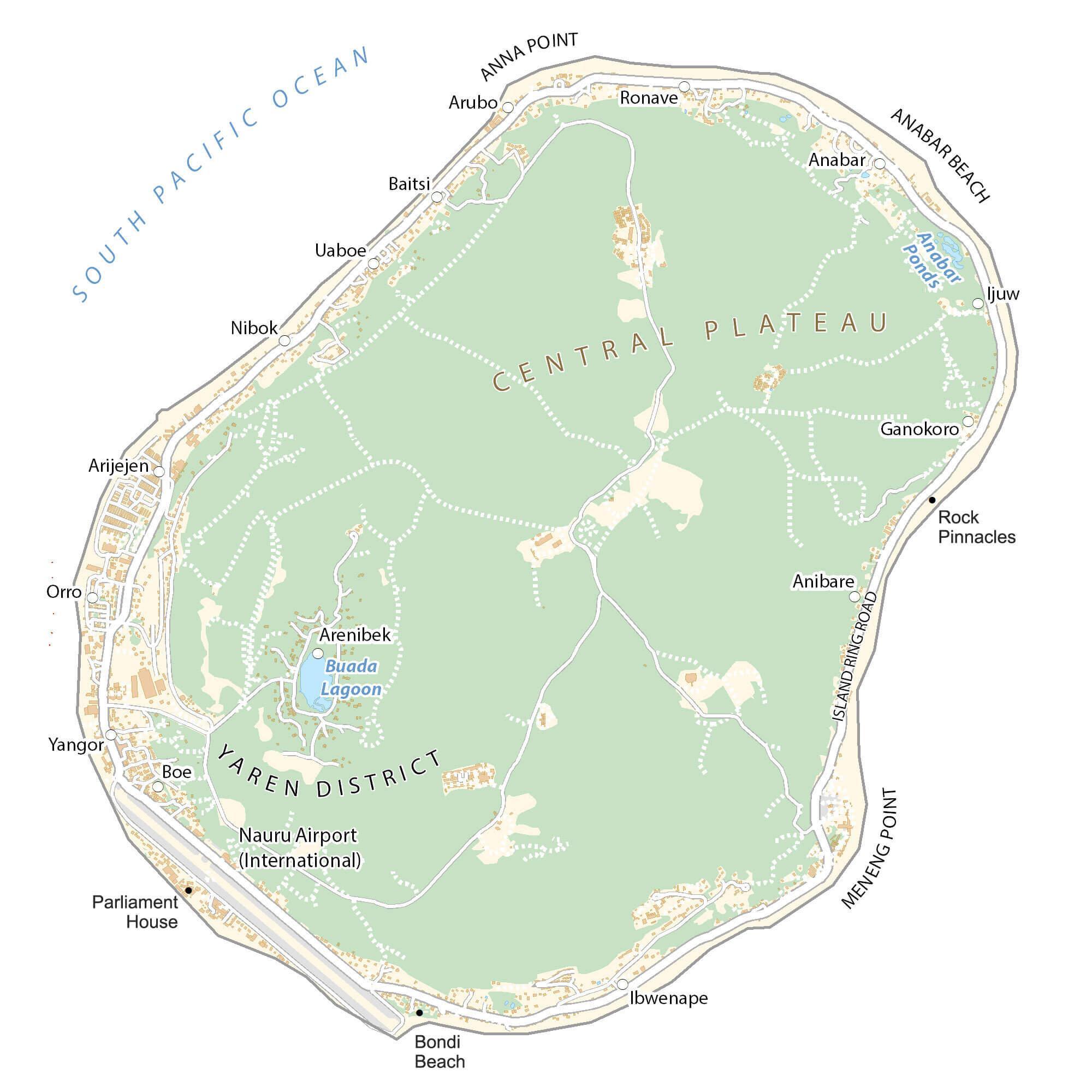
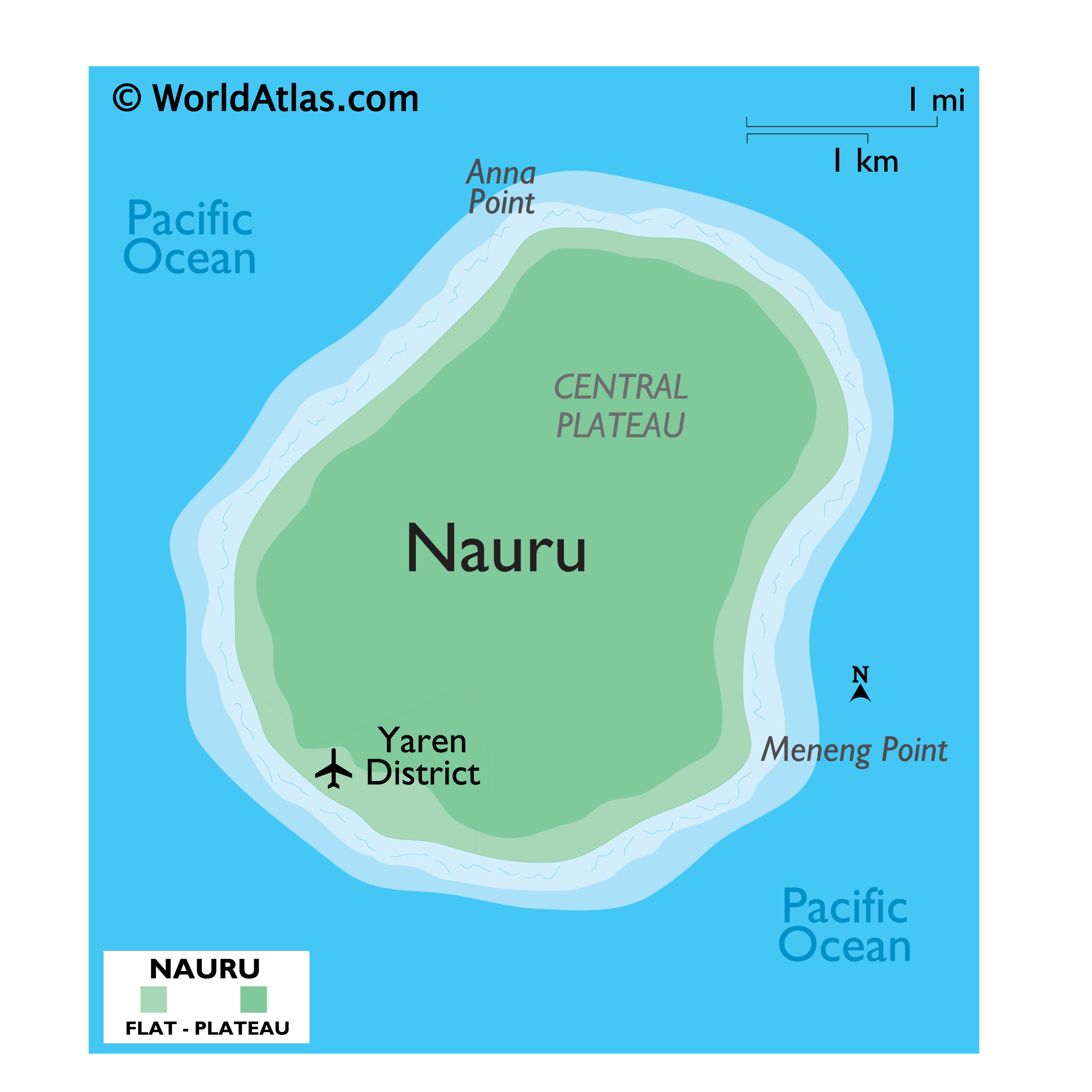
Covering an area of only 21 sq.km (8.1 sq mi), Nauru is an island nation and a microstate in Oceania, located in southwestern Pacific Ocean. Nauru is a raised, fossilized coral atoll and is one of the three great phosphate rock islands in the Pacific Ocean. The island is dominated by a central phosphate plateau which is surrounded by coral cliffs. A century of phosphate mining has stripped four-fifths of the total land area and has left behind a barren terrain.
Coral reefs surround the island and are exposed at low tide being dotted with pinnacles. The island is ringed by windswept palm trees and a sandy beach. Inward from the beach lies a wide fertile coastal strip of 150-300m. The highest point of the plateau is Command Ridge at an elevation of 233ft (71m). Due to presence of reefs, there are no harbors or protected anchorages.
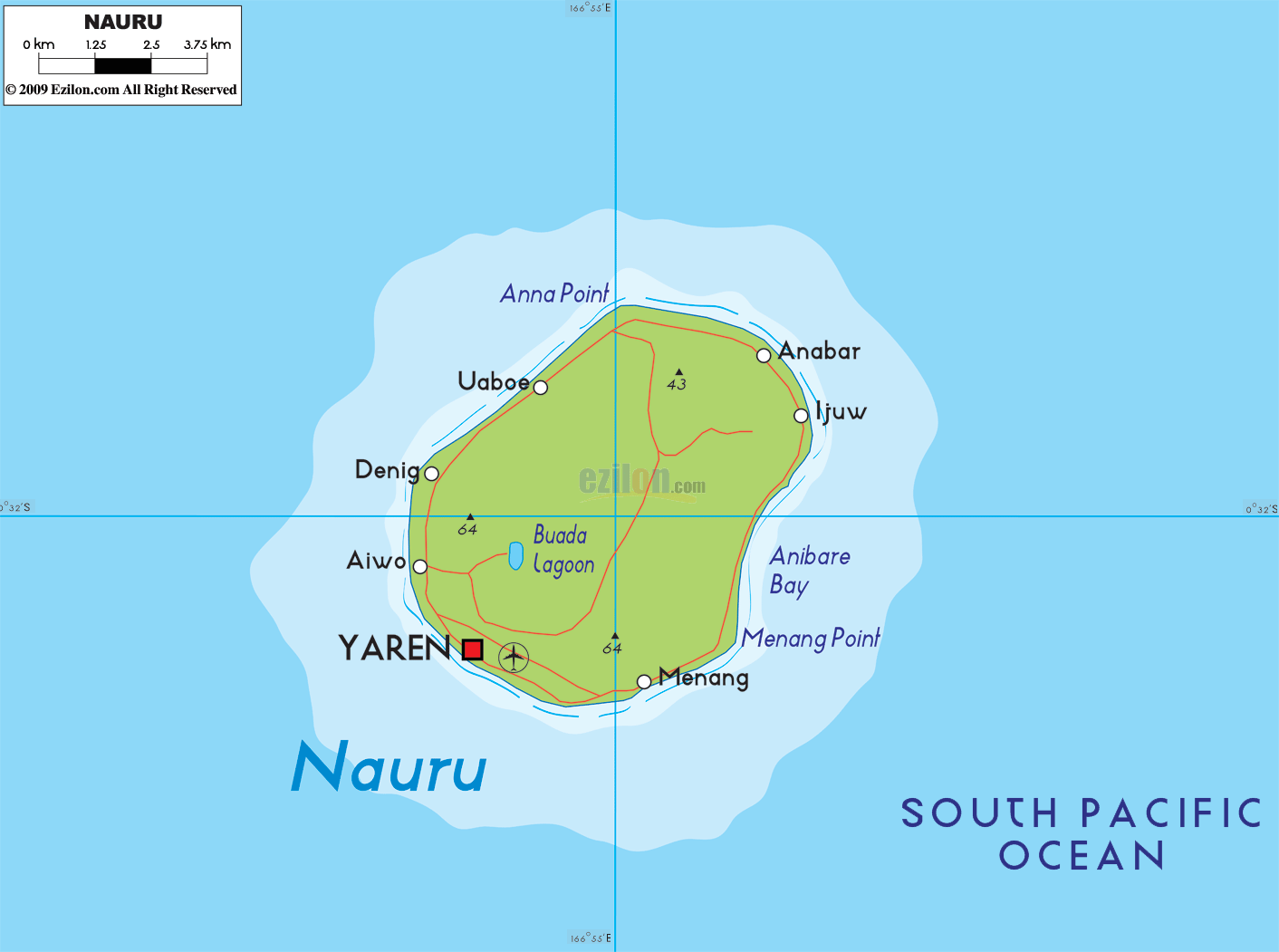
There are no rivers and lakes on the Island; only a landlocked, freshwater lake – Buada Lagoon is found in the Buada district of the Island. The lowest point is the South Pacific Ocean (0m).
| Flag: |  |
|---|---|
| Legal Name: | Republic of Nauru |
| Capital Value: | no official capital; government offices in the Yaren District |
| Official languages: | Nauruan, English
|
| Demonym(s): | Nauruan |
| Government: | Unitary parliamentary republic with an executive presidency under a non-partisan democracy |
| Legislature: | Parliament |
| Total Area: | 21 km² |
| Land Area: | 21 km² |
| Population: | 12,581 |
| Density: | 480/km (1,243.2/sq mi) (25th) |
| GDP: | $118.22 Million |
| GDP Per Capita: | $9,396.98 |
| Currency Value: | Australian dollars (AUD) |
| Driving side: | left |
| Calling code: | +674 |
| Internet TLD: | .nr |
Nestled in the heart of the Pacific Ocean, Nauru is the world’s smallest island country. This beautiful island is home to a variety of villages, roads, and stunning satellite imagery. Explore the map of Nauru to discover the beauty and culture of this remarkable country.
Online Interactive Political Map
Click on ![]() to view map in "full screen" mode.
to view map in "full screen" mode.
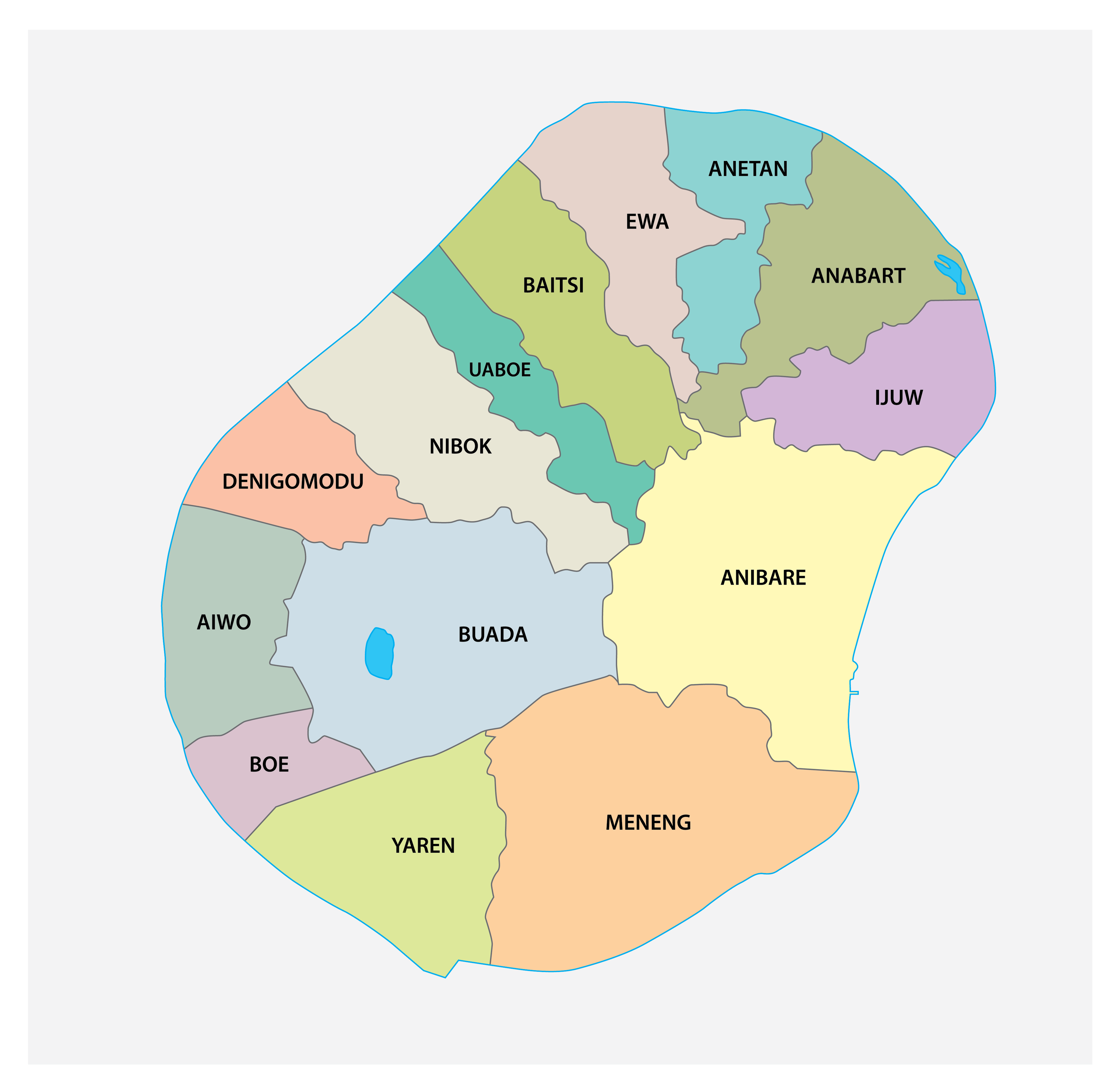
Nauru (officially, the Republic of Nauru) is divided into 14 administrative districts. These districts are: Aiwo, Anabar, Anetan, Anibare, Baitsi, Boe, Buada, Denigomodu, Ewa, Ijuw, Meneng, Nibok, Uaboe and Yaren. These districts are further divided into villages.
Covering an area of only 21 sq.km, the Micronesian island nation of Nauru is the world’s smallest republic and a microstate in Oceania, located in southwestern Pacific Ocean. The island nation has the world’s 3rd smallest land area and has no official capital city. Located on the southern coast of the island country is, the district of Yaren – the de facto capital of Nauru. It houses the legislature and a number of government offices. Situated in the western part of the island nation is, Denigomodu – the largest and the most populous district of Nauru.
Location Maps
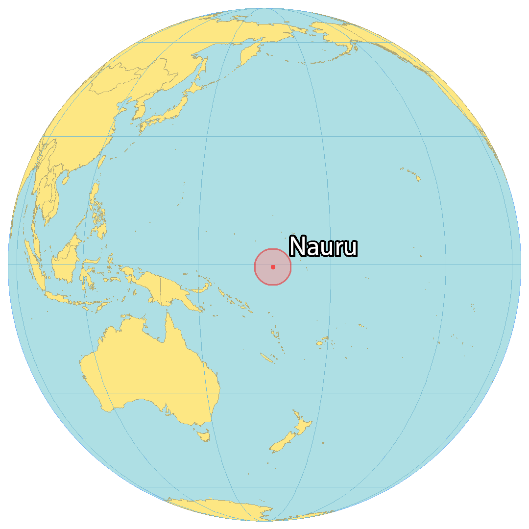
Where is Nauru?
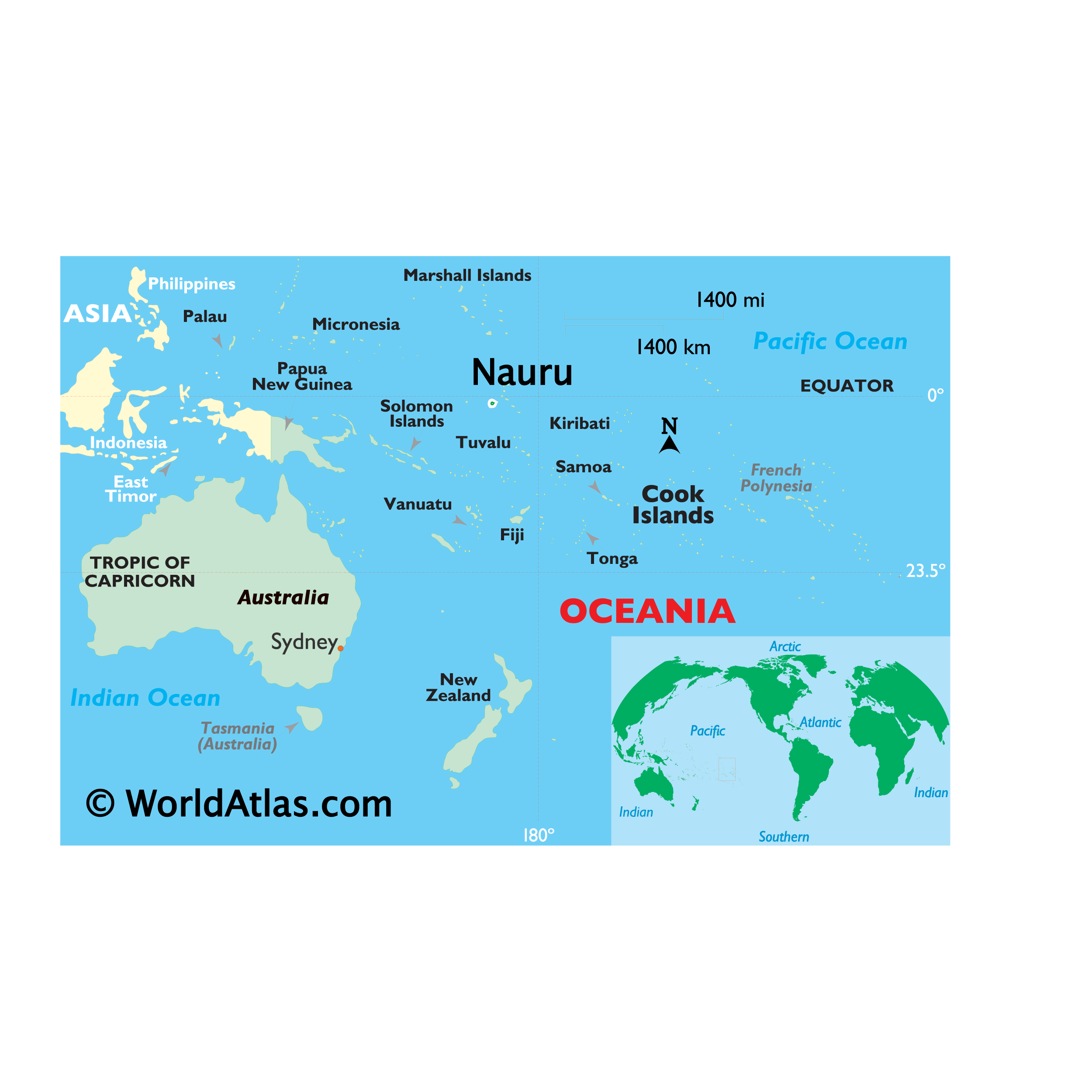
Nauru is a small island country and microstate located in Micronesia. Its coastline measures just 30 kilometers (19 mi) in the South Pacific Ocean. Nauru is near the Marshall Islands to the north, Tuvalu to the southeast, as well as the Solomon Islands and Papua New Guinea to the southwest.
It occupies an area of just 21 square kilometers (8.1 sq mi) which makes it the smallest island country. Additionally, this makes it the smallest country that is not a city-state. The (de facto) capital is Yaren, which is a district in the southwest of the island.

High Definition Political Map of Nauru
History
Nauru was first settled by Micronesians at least 3,000 years ago, and there is evidence of possible Polynesian influence. Comparatively little is known of Nauruan prehistory, although the island is believed to have had a long period of isolation, which accounts for the distinct language that developed among the inhabitants. There were traditionally 12 clans or tribes on Nauru, which are represented in the twelve-pointed star on the country’s flag. Traditionally, Nauruans traced their descent matrilineally. Inhabitants practised aquaculture: they caught juvenile milkfish (known as ibija in Nauruan), acclimatised them to freshwater, and raised them in the Buada Lagoon, providing a reliable food source. The other locally grown components of their diet included coconuts and pandanus fruit. The name “Nauru” may derive from the Nauruan word Anáoero, which means ‘I go to the beach.’
In 1798, the British sea captain John Fearn, on his trading ship Hunter (300 tons), became the first Westerner to report sighting Nauru, calling it “Pleasant Island”, because of its attractive appearance. From at least 1826, Nauruans had regular contact with Europeans on whaling and trading ships who called for provisions and fresh drinking water. The last whaler to call during the age of sail visited in 1904.
Around this time, deserters from European ships began to live on the island. The islanders traded food for alcoholic palm wine and firearms. The firearms were used during the 10-year Nauruan Civil War that began in 1878.
After an agreement with Great Britain, Nauru was annexed by Germany in 1888 and incorporated into Germany’s Marshall Islands Protectorate for administrative purposes. The arrival of the Germans ended the civil war, and kings were established as rulers of the island. The most widely known of these was King Auweyida. Christian missionaries from the Gilbert Islands arrived in 1888. The German settlers called the island “Nawodo” or “Onawero”. The Germans ruled Nauru for almost three decades. Robert Rasch, a German trader who married a Nauruan woman, was the first administrator, appointed in 1890.
Phosphate was discovered on Nauru in 1900 by the prospector Albert Fuller Ellis. The Pacific Phosphate Company began to exploit the reserves in 1906 by agreement with Germany, exporting its first shipment in 1907. In 1914, following the outbreak of World War I, Nauru was captured by Australian troops. In 1919, it was agreed by the Allied and Associated Powers that His Britannic Majesty should be the administering authority under a League of Nations mandate. The Nauru Island Agreement forged in 1919 between the governments of the United Kingdom, Australia, and New Zealand provided for the administration of the island and extraction of the phosphate deposits by an intergovernmental British Phosphate Commission (BPC). The terms of the League of Nations mandate were drawn up in 1920.
The island experienced an influenza epidemic and ongoing colonial strife through the early 20th century, with a mortality rate of 18 per cent among native Nauruans. In 1923, the League of Nations gave Australia a trustee mandate over Nauru, with the United Kingdom and New Zealand as co-trustees. On 6 and 7 December 1940, the German auxiliary cruisers Komet and Orion sank five supply ships in the vicinity of Nauru. Komet then shelled Nauru’s phosphate mining areas, oil storage depots, and the shiploading cantilever.
Japanese troops occupied Nauru on 25 August 1942. The Japanese built 2 airfields which were bombed for the first time on 25 March 1943, preventing food supplies from being flown to Nauru. The Japanese deported 1,200 Nauruans to work as labourers in the Chuuk Islands, which was also occupied by Japan. As part of the Allied strategy of island hopping from the Pacific islands towards the main islands of Japan, Nauru was bypassed and left to “wither on the vine”. Nauru was finally liberated on 13 September 1945, when commander Hisayaki Soeda surrendered the island to the Australian Army and the Royal Australian Navy. The surrender was accepted by Brigadier J. R. Stevenson, who represented Lieutenant General Vernon Sturdee, the commander of the First Australian Army, aboard the warship HMAS Diamantina. Arrangements were made to repatriate from Chuuk the 745 Nauruans who survived Japanese captivity there. They were returned to Nauru by the BPC ship Trienza in January 1946.
In 1947, a trusteeship was established by the United Nations, with Australia, New Zealand, and the United Kingdom as trustees. Under those arrangements, the UK, Australia, and New Zealand were a joint administering authority. The Nauru Island Agreement provided for the first administrator to be appointed by Australia for five years, leaving subsequent appointments to be decided by the three governments. However, in practice, administrative power was exercised by Australia alone.
The 1948 Nauru riots occurred when Chinese guano mining workers went on strike over pay and conditions. The Australian administration imposed a state of emergency with Native Police and armed volunteers of locals and Australian officials being mobilised. This force, using sub-machine guns and other firearms, opened fire on the Chinese workers killing two and wounding sixteen. Around 50 of the workers were arrested and two of these were bayoneted to death while in custody. The trooper who bayoneted the prisoners was charged but later acquitted on grounds that the wounds were “accidentally received.” The governments of the Soviet Union and China made official complaints against Australia at the United Nations over this incident.
In 1964, it was proposed to relocate the population of Nauru to Curtis Island off the coast of Queensland, Australia. By that time, Nauru had been extensively mined for phosphate by companies from Australia, Britain, and New Zealand, damaging the landscape so much that it was thought the island would be uninhabitable by the 1990s. Rehabilitating the island was seen as financially impossible. In 1962, Australian Prime Minister Robert Menzies said that the three countries involved in the mining had an obligation to provide a solution for the Nauruan people, and proposed finding a new island for them. In 1963, the Australian Government proposed to acquire all the land on Curtis Island (which was considerably larger than Nauru) and then offer the Nauruans freehold title over the island and that the Nauruans would become Australian citizens. The cost of resettling the Nauruans on Curtis Island was estimated to be £10 million (A$288 million in 2018), which included housing and infrastructure and the establishment of pastoral, agricultural, and fishing industries. However, the Nauruan people did not wish to become Australian citizens and wanted to be given sovereignty over Curtis Island to establish themselves as an independent nation, which Australia would not agree to. Nauru rejected the proposal to move to Curtis Island, instead choosing to become an independent nation operating their mines in Nauru.
Nauru became self-governing in January 1966, and following a two-year constitutional convention, it became independent on 31 January 1968 under founding president Hammer DeRoburt. In 1967, the people of Nauru purchased the assets of the British Phosphate Commissioners, and in June 1970 control passed to the locally-owned Nauru Phosphate Corporation (NPC). Income from the mines made Nauruans among the richest people in the world. In 1989, Nauru took legal action against Australia in the International Court of Justice over Australia’s administration of the island, in particular, Australia’s failure to remedy the environmental damage caused by phosphate mining. Certain Phosphate Lands: Nauru v. Australia led to an out-of-court settlement to rehabilitate the mined-out areas of Nauru.
In response to the COVID-19 pandemic, a state of emergency was declared in Nauru on 17 March 2020. The declaration to minimize the outbreak was signed by President Lionel Aingimea during a period of 30 days.
Physical Map of Nauru
Geography
Nauru is a 21 km (8.1 sq mi), oval-shaped island in the southwestern Pacific Ocean, 55.95 km (34.77 mi) south of the Equator. The island is surrounded by a coral reef, which is exposed at low tide and dotted with pinnacles. The presence of the reef has prevented the establishment of a seaport, although channels in the reef allow small boats access to the island. A fertile coastal strip 150 to 300 m (490 to 980 ft) wide lies inland from the beach.
Coral cliffs surround Nauru’s central plateau. The highest point of the plateau, called the Command Ridge, is 71 m (233 ft) above sea level.
The only fertile areas on Nauru are on the narrow coastal belt, where coconut palms flourish. The land around Buada Lagoon supports bananas, pineapples, vegetables, pandanus trees, and indigenous hardwoods, such as the tamanu tree.
Nauru was one of three great phosphate rock islands in the Pacific Ocean, along with Banaba (Ocean Island), in Kiribati, and Makatea, in French Polynesia. The phosphate reserves on Nauru are now almost entirely depleted. Phosphate mining in the central plateau has left a barren terrain of jagged limestone pinnacles up to 15 m (49 ft) high. Mining has stripped and devastated about 80 per cent of Nauru’s land area, leaving it uninhabitable, and has also affected the surrounding exclusive economic zone; 40 per cent of marine life is estimated to have been killed by silt and phosphate runoff.
There are limited natural sources of freshwater on Nauru. Rooftop storage tanks collect rainwater. The islanders are mostly dependent on three desalination plants housed at Nauru’s Utilities Agency.
Climate
Nauru’s climate is hot and very humid year-round because of its proximity to the equator and the ocean. Nauru is hit by monsoon rains between November and February, but rarely has cyclones. Annual rainfall is highly variable and is influenced by the El Niño–Southern Oscillation, with several significant recorded droughts. The temperature on Nauru ranges between 30 and 35 °C (86 and 95 °F) during the day and is quite stable at around 25 °C (77 °F) at night.
Streams and rivers do not exist in Nauru. Water is gathered from roof catchment systems. Water is brought to Nauru as ballast on ships returning for loads of phosphate.
Ecology
Fauna is sparse on the island because of a lack of vegetation and the consequences of phosphate mining. Many indigenous birds have disappeared or become rare owing to the destruction of their habitat. There are about 60 recorded vascular plant species native to the island, none of which are endemic. Coconut farming, mining, and introduced species have seriously disturbed the native vegetation.
There are no native land mammals, but there are native insects, land crabs, and birds, including the endemic Nauru reed warbler. The Polynesian rat, cats, dogs, pigs, and chickens have been introduced to Nauru from ships. The diversity of the reef marine life makes fishing a popular activity for tourists on the island; also popular are scuba diving and snorkelling.
Nauru Satellite Map