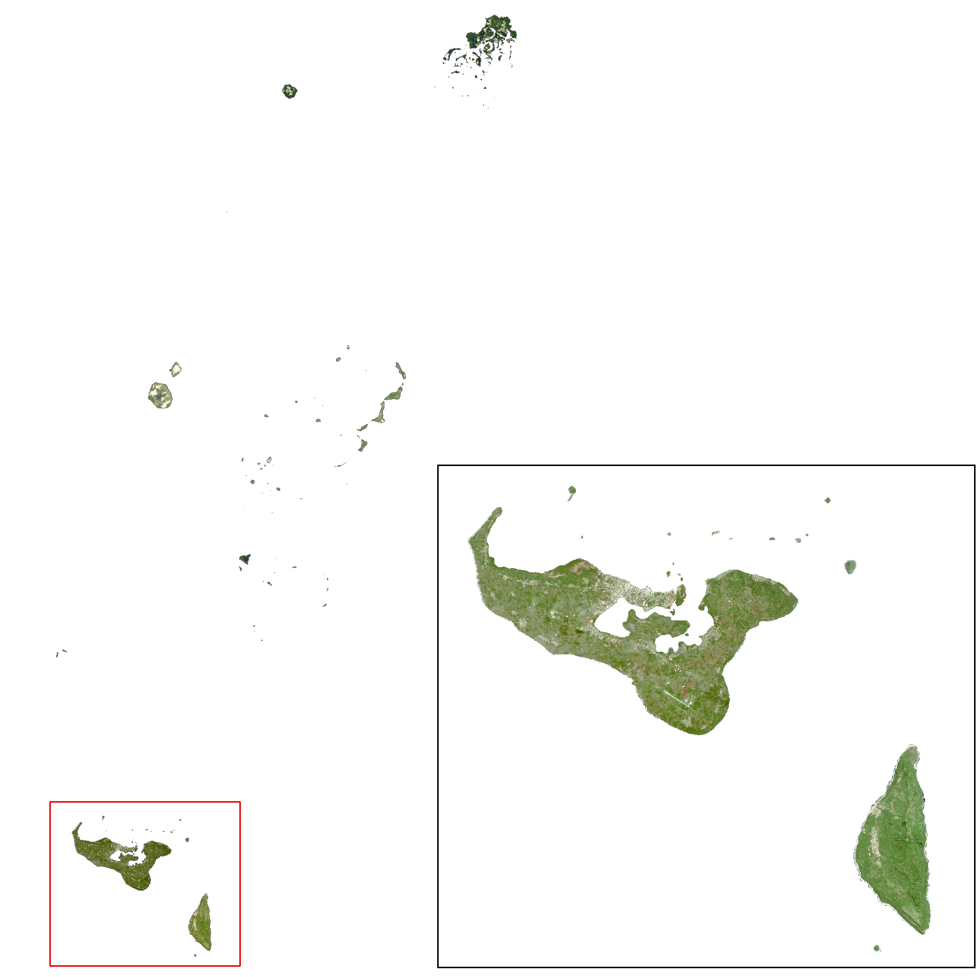
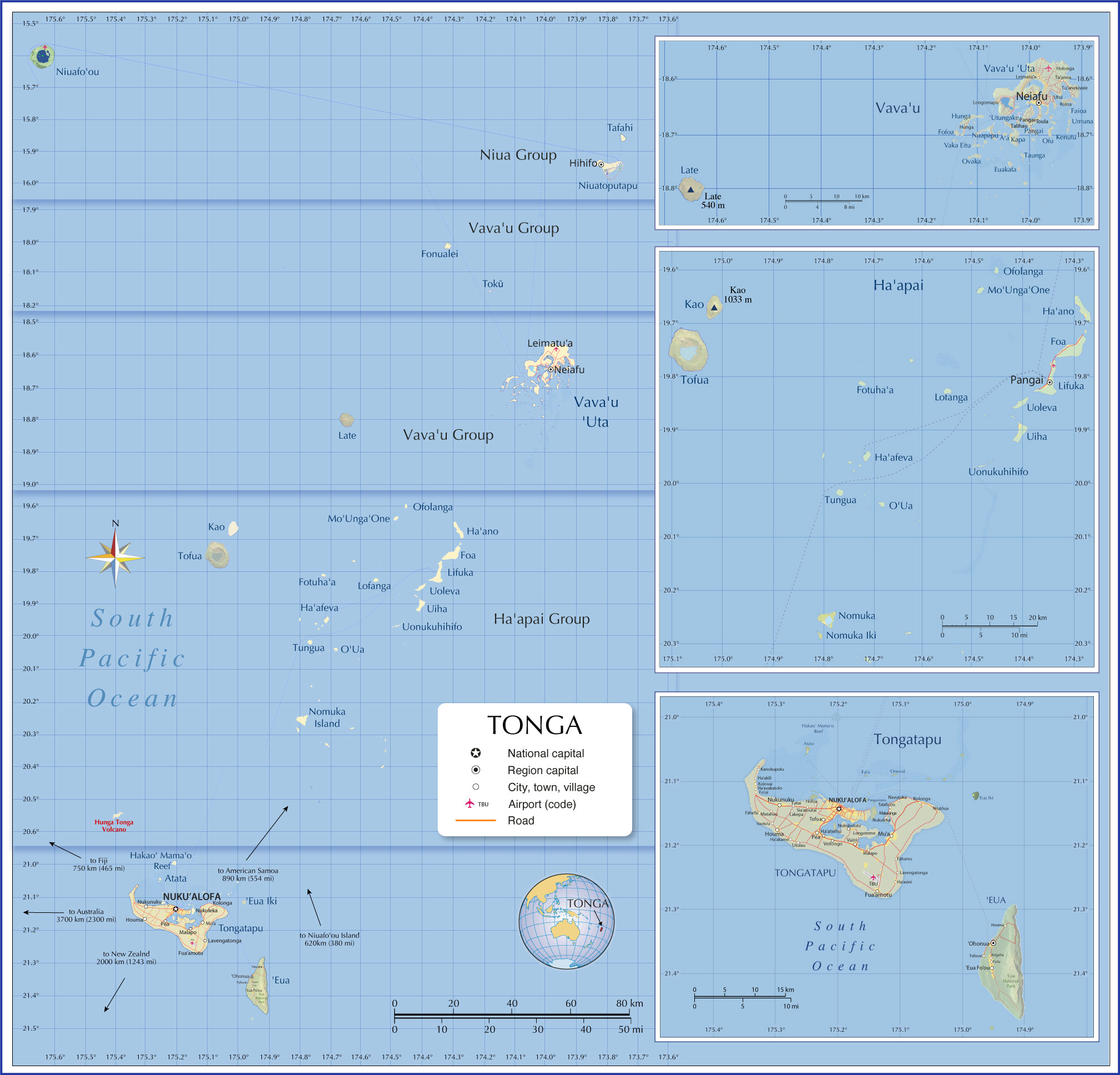
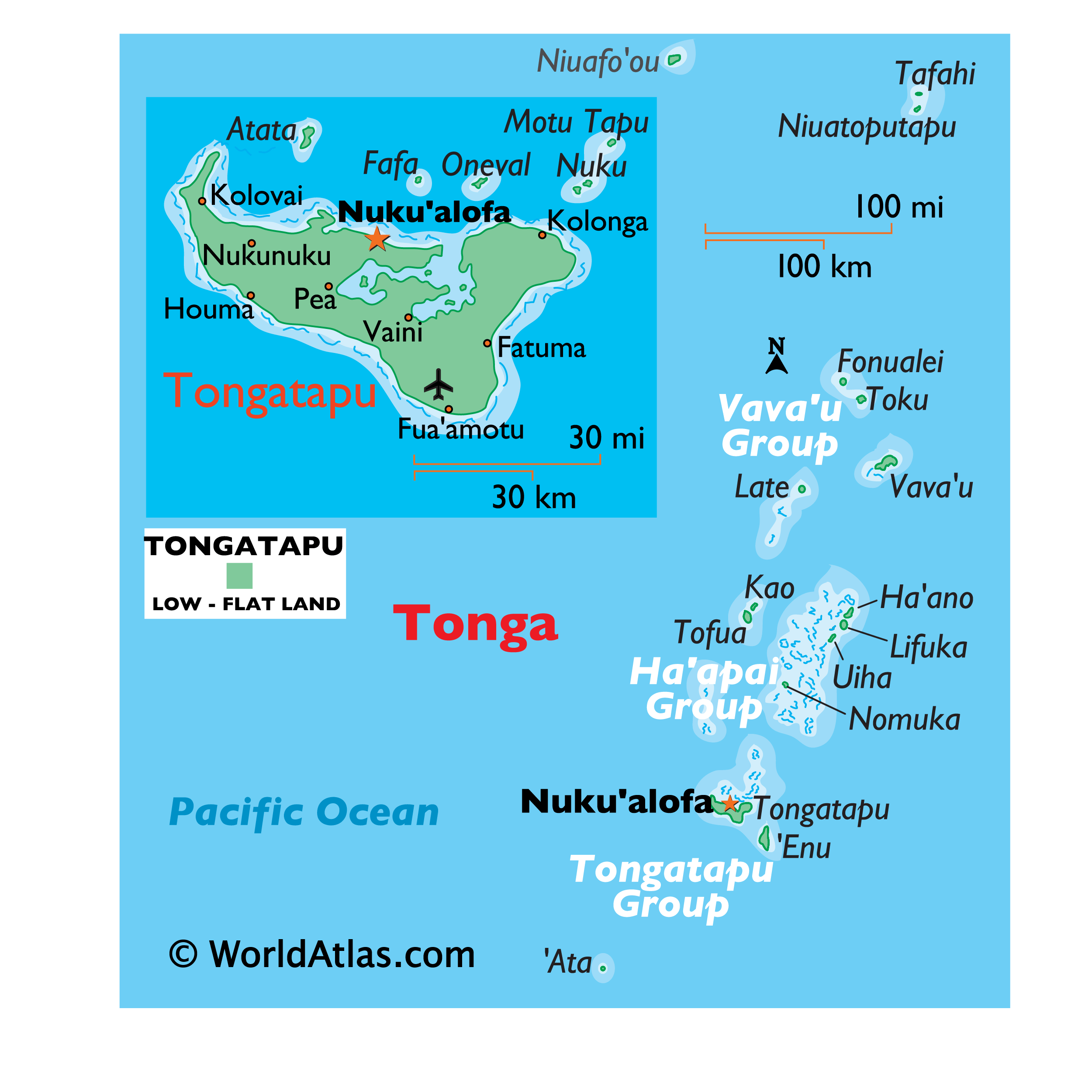
Covering a total area of 750 sq.km (289 sq mi), Tonga is an archipelago composed of 169 islands, of which only 36 islands are inhabited and is located in the South Pacific Ocean. The three largest islands are Tongatapu, Ha’apai, and Vava’u, with Tongatapu being the most populated. Due to its location within the Pacific Ring of Fire, Tonga experiences relatively frequent volcanic activity, with its last eruption occurring in 2009, near the island of Hunga Tonga – approximately 6.8 miles (11 km) north of the capital city.
Tonga’s western islands make up the Volcanic Arch, and are therefore volcanic in origin, having been formed from heated materials that rose to the surface of the ocean. The eastern Tongan islands sit above the Tonga ridge, running parallel to the Volcanic Arch, and were formed from elevated limestone and uplifted coral formations. These islands are not volcanic. Located east of Tonga, in the depths of the ocean, is the Tonga Trench – one of the deepest parts of the Pacific.
Its deepest point, known as the Horizon Deep, plunges 35,702 ft. (10,882 m) below the surface of the water. There are no significant rivers within the Tonga archipelago, however the largest lake is located on the island of Tofua, and is a steaming hot volcano crater with a depth of 1,600 ft. (500 m).
The highest point of the country is an unnamed elevation on Kao Island that peaks at 3,389 ft. (1,033 m); the lowest point is the Pacific Ocean (0m).
| Flag: |  |
|---|---|
| Legal Name: | Kingdom of Tonga |
| Capital Value: | Nuku’alofa |
| Official languages: |
|
| Demonym(s): | Tongan |
| Government: | Unitary parliamentary semi-constitutional monarchy |
| Legislature: | Legislative Assembly |
| Total Area: | 747 km² |
| Land Area: | 717 km² |
| Water Area: | 30 km² |
| Population: | 104,494 |
| Density: | 139/km (360.0/sq mi) (76th) |
| GDP: | $450.35 Million |
| GDP Per Capita: | $4,364.02 |
| Currency Value: | Pa’anga (TOP) |
| Driving side: | left |
| Calling code: | +676 |
| Internet TLD: | .to |
Explore the stunning beauty of the Kingdom of Tonga with this Tonga Map Collection! This collection includes a reference map, satellite imagery, and an elevation map. You can easily locate cities, towns, roads, highways, and even islands such as Nuku’alofa on the main island of Tongatapu. With this collection, you can explore the beauty of Tonga in all its glory!
Online Interactive Political Map
Click on ![]() to view map in "full screen" mode.
to view map in "full screen" mode.
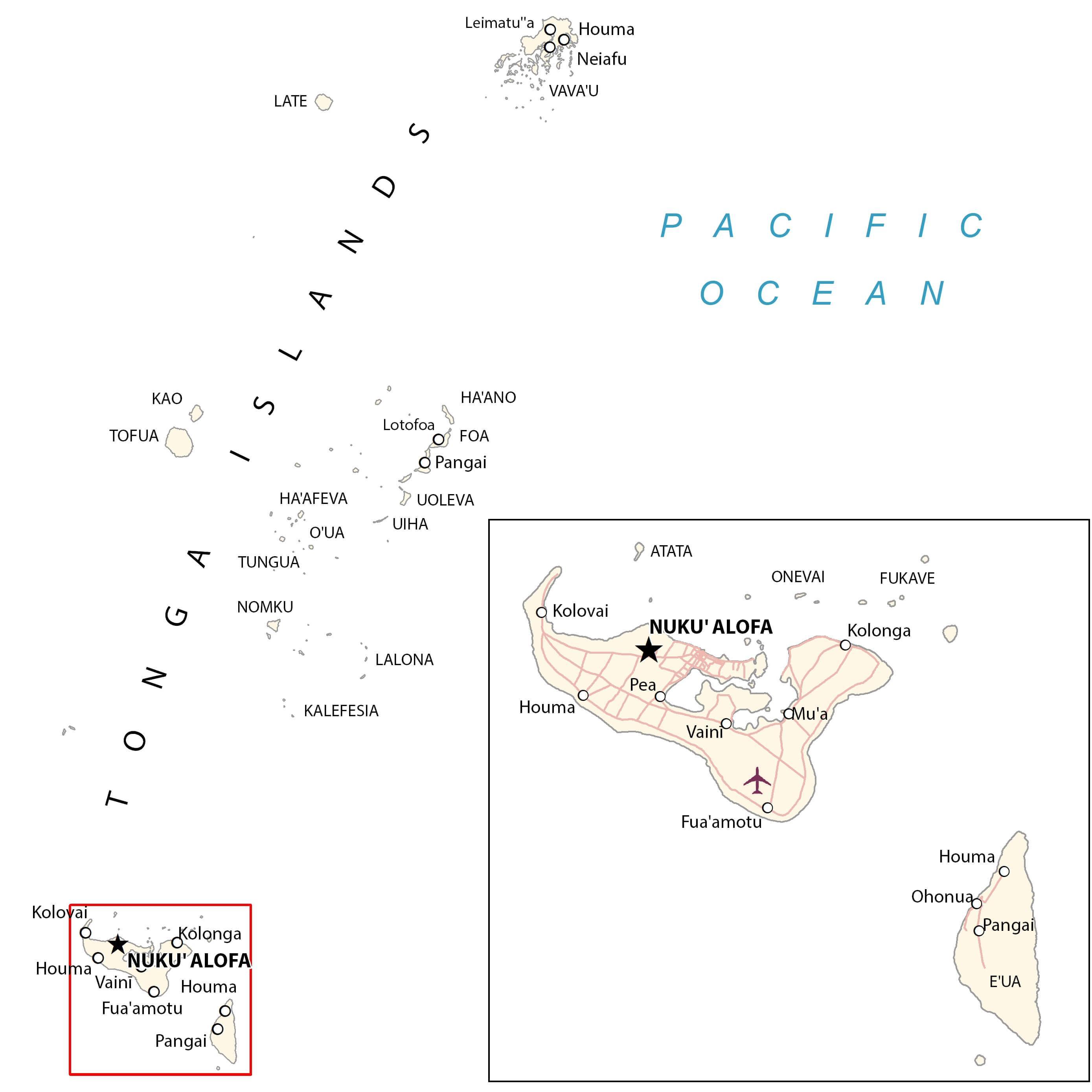
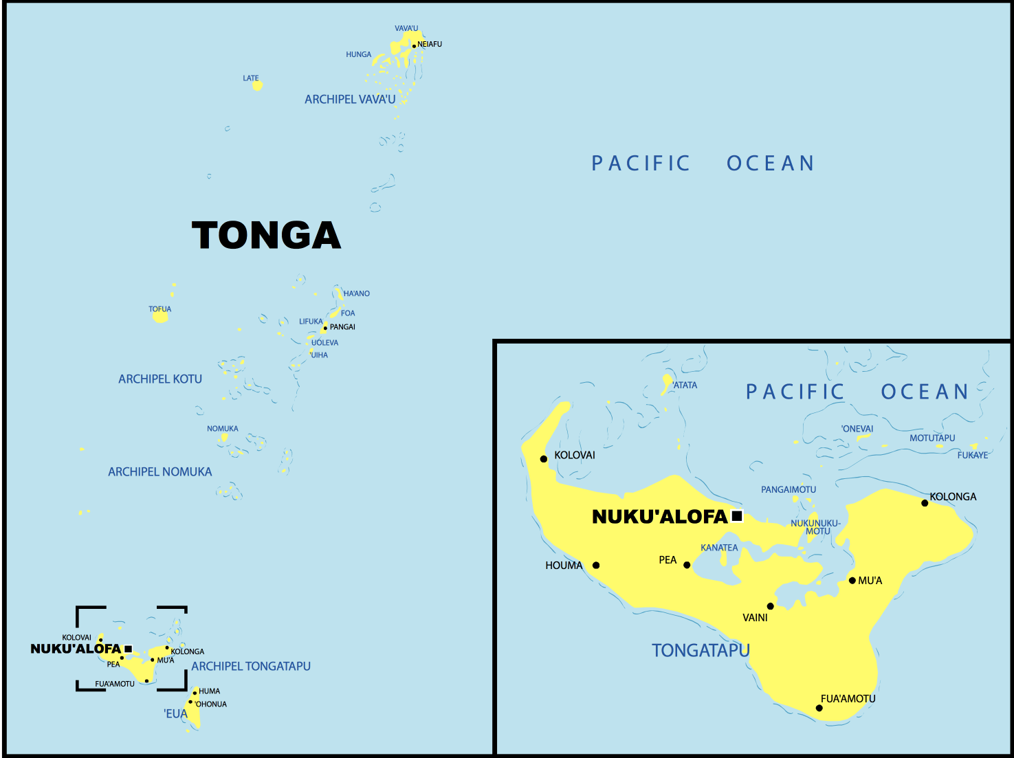
Tonga (officially, the Kingdom of Tonga) is divided into 5 island divisions. In alphabetical order, these divisions are: Éua, Ha’apai, Ongo Niua, Tongatapu and Vavaú. These administrative divisions are further subdivided into a total of 23 districts.
Covering a total area of 750 sq.km, Tonga is an archipelago composed of 169 islands, of which only 36 islands are inhabited. Located on the northern coast of Tongatapu (the archipelago’s largest island) is, Nukua’lofa– the capital and the largest city of Tonga. It is the administrative, commercial and economic center of the country. The harbor at Nukua’lofa is the chief port and one of the busiest in Tonga.
Location Maps
Where is Tonga?
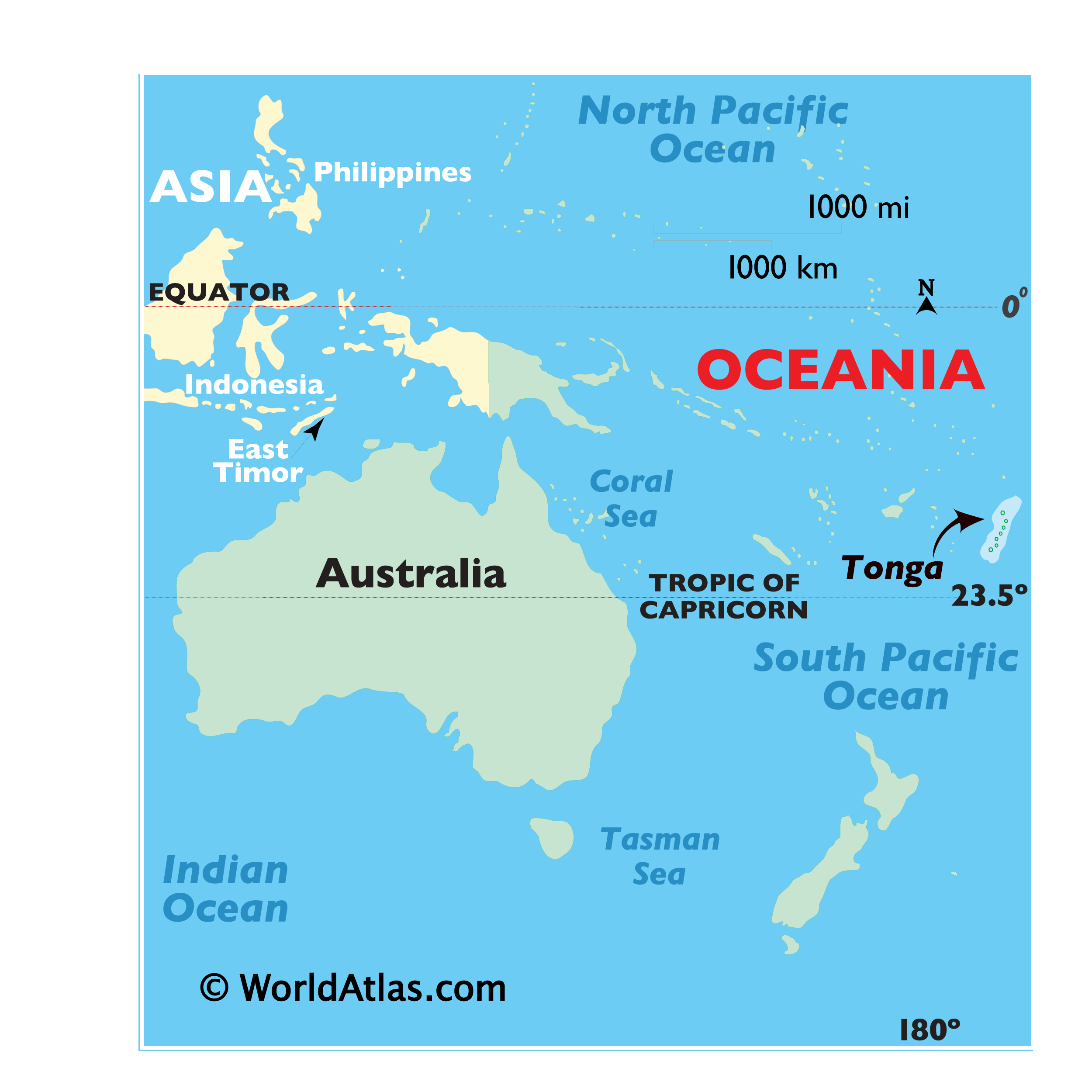
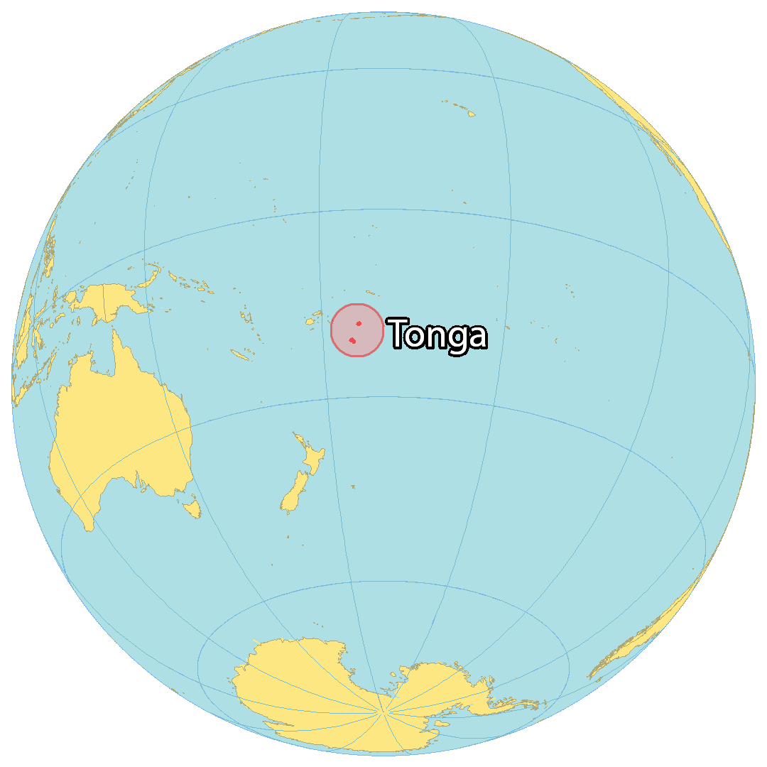
Tonga is a group of 176 islands (36 of which are inhabited) situated in the South Pacific Ocean. The nation is renowned for its stunning beaches, coral reefs, and tropical rainforests. It is located in Polynesia near American Samoa to the northeast, Samoa to the north, Fiji Islands to the west, and New Zealand to the southwest.
The capital and largest city of Tonga is Nuku’alofa on the main island, Tongatapu. Other major towns and villages are Neiafu, Mu’a, and Kolovai. It lies between 15°S and 22°S in the South Pacific Ocean, giving it a tropical rainforest climate.
Tonga extends for 800 kilometers (500 mi) in a north-south direction. Altogether, the islands of Tonga occupy an area of 750 square kilometers (290 sq mi). This makes it larger than Singapore but smaller than Kiribati. Its landscapes comprise of coral atolls, sandy beaches, and coral reefs. There are approximately 419 kilometers (260 mi) of coastline.

High Definition Political Map of Tonga

History
According to Tongan mythology, the demigod Maui drew up a group of islands from the ocean, first appearing Tongatapu, the Ha’apai Islands and Vava’u, integrating into what became modern-day Tonga.
An Austronesian-speaking group linked to what archaeologists call the Lapita culture covered from Island Melanesia to Samoa, and then on to inhabit Tonga sometime between 1500 and 1000 BC. Scholars still debate exactly when Tonga was first settled, but thorium dating confirms that settlers had arrived in the earliest known inhabited town, Nukuleka, by 888 BC, ± 8 years. Tonga’s precontact history was shared via oral history, which was passed down from generation to generation.
By the 12th century, Tongans and the Tongan monarch, the Tuʻi Tonga, had acquired a reputation across the central Pacific – from Niue, Samoa, Rotuma, Wallis and Futuna, New Caledonia to Tikopia, leading some historians to speak of a Tuʻi Tonga Empire having existed during that period. Civil wars are known to have occurred in Tonga in the 15th and 17th centuries.
The Tongan people first encountered Europeans in 1616, when the Dutch vessel Eendracht, captained by Willem Schouten, made a short visit to the islands for the purpose of engaging in trade. Later, other Dutch explorers arrived, including Jacob Le Maire (who visited the northern island of Niuatoputapu); and Abel Tasman (who visited Tongatapu and Haʻapai) in 1643. Later noteworthy European visitors included James Cook, of the British Royal Navy, in 1773, 1774, and 1777; Spanish Navy explorers Francisco Mourelle de la Rúa in 1781; Alessandro Malaspina in 1793; the first London missionaries in 1797; and a Wesleyan Methodist minister, Reverend Walter Lawry, in 1822.
Whaling vessels were among the earliest regular Western visitors. The first of these on record is the Ann and Hope, which was reported to have been seen among the islands of Tonga in June 1799. The last known whaling visitor was the Albatross in 1899. That ship arrived in Tonga seeking a resupply of water, food, and wood. The islands most regularly visited by Westerners were Ata, ‘Eua, Ha’apai, Tongatapu and Vava’u. Sometimes, Tongan men were recruited to serve as crewmen on these vessels. The United States Exploring Expedition visited Tonga in 1840.
In 1845, an ambitious young Tongan warrior, strategist, and orator named Tāufaʻāhau united Tonga into a kingdom. He held the chiefly title of Tuʻi Kanokupolu, but had been baptised by Methodist missionaries with the name Siaosi (“George”) in 1831. In 1875, with the help of missionary Shirley Waldemar Baker, he declared Tonga a constitutional monarchy; formally adopted the Western royal style; emancipated the “serfs”; enshrined a code of law, land tenure, and freedom of the press; and limited the power of the chiefs.
Tonga became a protected state under a Treaty of Friendship with Britain on 18 May 1900, when European settlers and rival Tongan chiefs unsuccessfully tried to oust the man who had succeeded Tāufaʻāhau as king. The treaty posted no higher permanent representative on Tonga than a British consul (1901–1970). Under the protection of Britain, Tonga maintained its sovereignty, and remained the only Pacific nation to retain its monarchical government. The Tongan monarchy follows an uninterrupted succession of hereditary rulers from one family.
The 1918 flu pandemic, brought to Tonga by a ship from New Zealand, killed 1,800 Tongans, a mortality rate of about 8%.
The Treaty of Friendship and Tonga’s protection status ended in 1970 under arrangements that had been established by Tonga’s Queen Salote Tupou III before her death in 1965. Owing to its British ties, Tonga joined the Commonwealth in 1970 (atypically as a country that had its own monarch, rather than having the United Kingdom’s monarch, along with Malaysia, Lesotho, and Eswatini). Tonga became a member of the United Nations in September 1999. While exposed to colonial pressures, Tonga has always governed itself, which makes it unique in the Pacific.
In January 2022, the Hunga Tonga–Hunga Haʻapai volcano, 65 km (40 mi) north of the main island of Tongatapu, erupted, causing a tsunami which inundated parts of the archipelago, including the capital Nukuʻalofa. The eruption affected the kingdom heavily, cutting off most communications and killing four people in Tonga, including a British national who ran an animal shelter and died trying to save her dogs. In Peru, two women drowned due to abnormal tsunami waves. It took around five weeks to repair a submarine fiber optic cable used in the Tonga Cable System for internet and telephone connectivity. Business magnate Elon Musk directed his company SpaceX to provide emergency internet services to households remaining under blackout via a Starlink satellite infrastructure network based in neighbouring Fiji.
Physical Map of Tonga
Geography
Located in Oceania, Tonga is an archipelago in the South Pacific Ocean, directly south of Samoa and about two-thirds of the way from Hawai’i to New Zealand. Its 171 islands, 45 of them inhabited, are divided into three main groups – Vava’u, Ha’apai, and Tongatapu – and cover an 800-kilometre (500-mile)-long north–south line.
The largest island, Tongatapu, on which the capital city of Nukuʻalofa is located, covers 257 square kilometres (99 sq mi). Geologically the Tongan islands are of two types: most have a limestone base formed from uplifted coral formations; others consist of limestone overlaying a volcanic base.
Climate
Tonga has a tropical rainforest climate (Af) with a distinct warm period (December–April), during which the temperatures rise above 32 °C (89.6 °F), and a cooler period (May–November), with temperatures rarely rising above 27 °C (80.6 °F). The temperature and rainfall range from 23 °C (73.4 °F) and 1,700 mm (66.9 in) on Tongatapu in the south to 27 °C (80.6 °F) and 2,970 mm (116.9 in) on the more northerly islands closer to the Equator.
The average wettest period is around March with on average 263 mm (10.4 in). The average daily humidity is 80%. The highest temperature recorded in Tonga was 35 °C (95 °F) on 11 February 1979 in Vava’u. The coldest temperature recorded in Tonga was 8.7 °C (47.7 °F) on 8 September 1994 in Fua’amotu. Temperatures of 15 °C (59 °F) or lower are usually measured in the dry season and are more frequent in southern Tonga than in the northern islands. The tropical cyclone season currently runs from 1 November to 30 April, though tropical cyclones can form and affect Tonga outside of the season. According to the WorldRiskReport 2021, Tonga ranks third among the countries with the highest disaster risk worldwide – mainly due to the country’s exposure to multiple natural hazards.
Ecology
Tonga contains the Tongan tropical moist forests terrestrial ecoregion.
In Tonga, dating back to Tongan legend, flying bats are considered sacred and are the property of the monarchy. Thus, they are protected and cannot be harmed or hunted. As a result, flying fox bats have thrived in many of the islands of Tonga.
The bird life of Tonga includes a total of 73 species, of which two are endemic; the Tongan whistler and the Tongan megapode. Five species have been introduced by humans, and eight are rare or accidental. Seven species are globally threatened.
Tonga Satellite Map