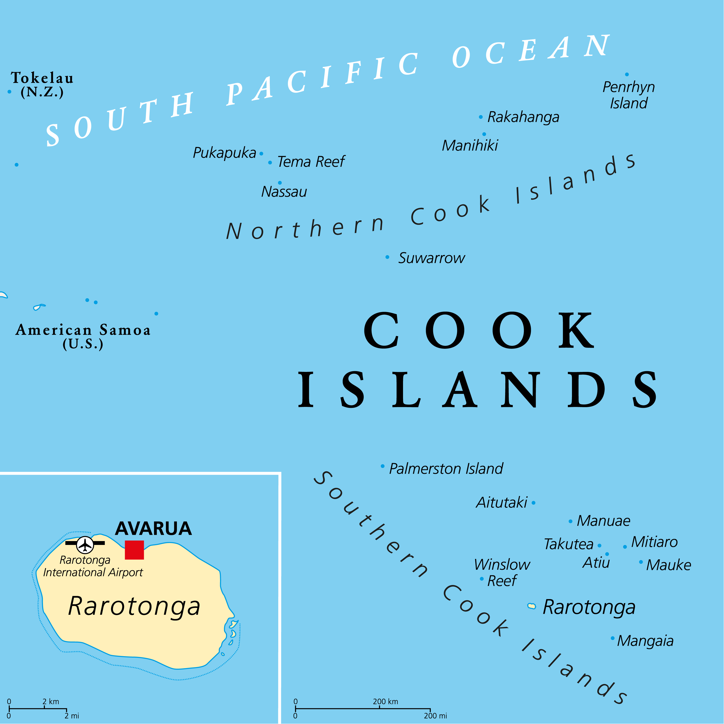
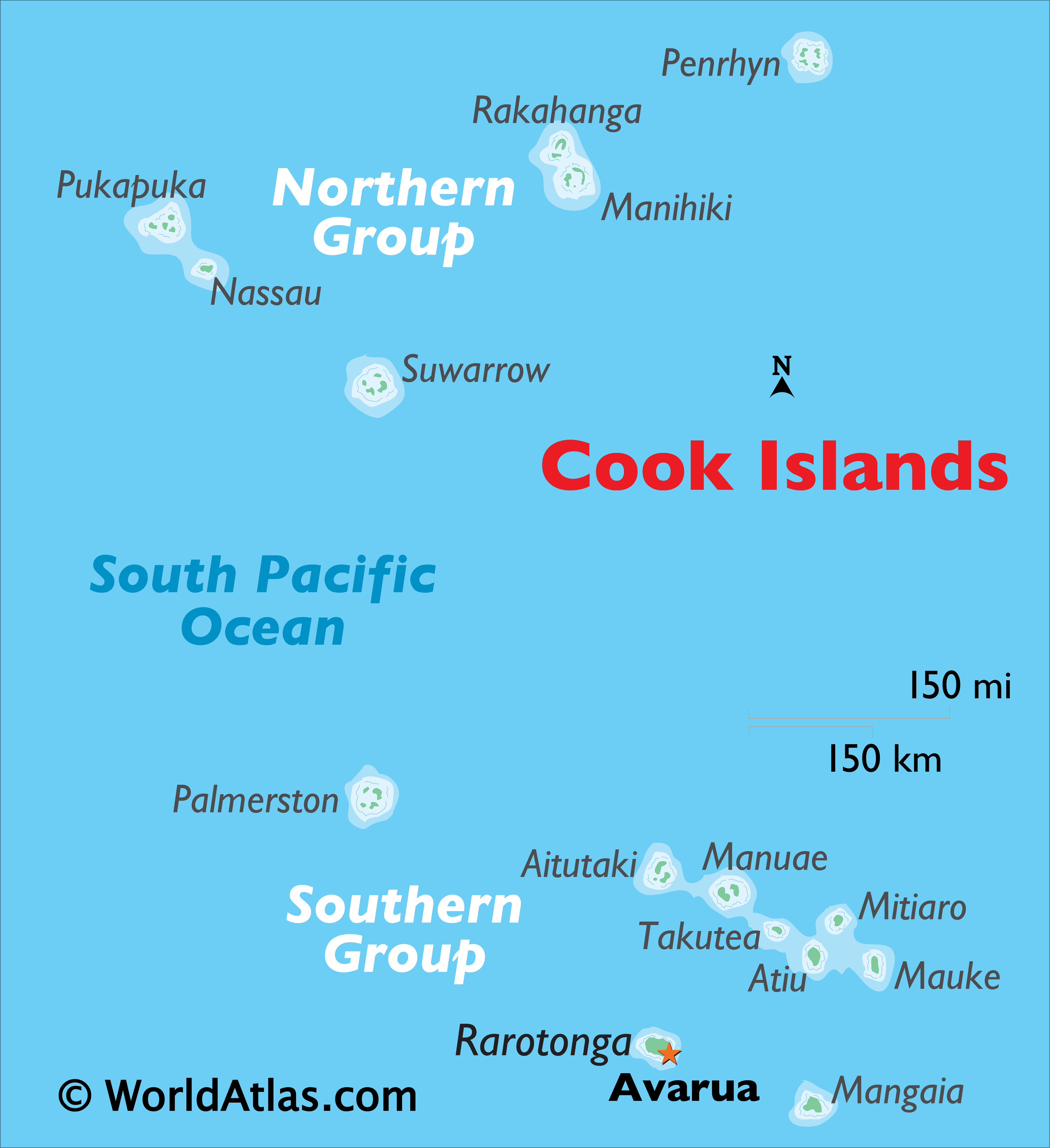
Covering a total land area of 240 sq. km, the Cook Islands are a group of 15 small islands that are spread over 2 million sq. km in the South Pacific Ocean. The 15 islands are geographically divided into the Northern and Southern island groups.
As can be observed on the map above, the northern islands are mostly low-lying and sparsely populated coral atolls; and includes the islands of Manihiki, Nassau, Penrhyn, Pukapuka, Rakahanga, and Suwarrow. The southern group generally consists of much larger higher islands that are volcanic in origin and more densely populated. The southern island group includes Rarotonga, Aitutaki, Atiu, Mangaia, Manuae, Mauke, Mitiaro, Palmerston, and Takutea. The distance between the two island groups is enormous. The highest point is Te Manga that rises to 652m on the Rarotonga island. The lowest point is the Pacific Ocean (0m).
The largest island of Rarotonga is lush green and is ringed by white-sand beaches. Along with the stunning coral atoll of Aitutaki (with its blue lagoon and rich marine life), they epitomize the beauty of the Cook Islands and the entire Polynesian group.
| Legal Name: | Cook Islands |
|---|---|
| Capital Value: | Avarua |
| Official languages: |
|
| Demonym(s): | Cook Islander |
| Government: | Unitary constitutional monarchy |
| Legislature: | Parliament |
| Total Area: | 236 km² |
| Land Area: | 236 km² |
| Population: | 9,038 |
| Density: | 63/km (163.2/sq mi) (138th) |
| Currency Value: | NZ dollars (NZD) |
| Driving side: | left |
| Calling code: | +682 |
| Internet TLD: | .ck |
Location Maps
Where is Cook Islands?
High Definition Political Map of Cook Islands
History
The Cook Islands were first settled around AD 1000 by Polynesian people who are thought to have migrated from Tahiti, an island 1,154 kilometres (717 mi) to the northeast of the main island of Rarotonga.
The first European contact with the islands took place in 1595 when the Spanish navigator Álvaro de Mendaña de Neira sighted the island of Pukapuka, which he named San Bernardo (Saint Bernard). Pedro Fernandes de Queirós, a Portuguese captain at the service of the Spanish Crown, made the first European landing in the islands when he set foot on Rakahanga in 1606, calling the island Gente Hermosa (Beautiful People).
The British navigator Captain James Cook arrived in 1773 and again in 1777 giving the island of Manuae the name Hervey Island. The Hervey Islands later came to be applied to the entire southern group. The name “Cook Islands”, in honour of Cook, first appeared on a Russian naval chart published by Adam Johann von Krusenstern in the 1820s.
In 1813 John Williams, a missionary on the colonial brig Endeavour (not the same ship as Cook’s) made the first recorded European sighting of Rarotonga. The first recorded landing on Rarotonga by Europeans was in 1814 by the Cumberland; trouble broke out between the sailors and the Islanders and many were killed on both sides. The islands saw no more Europeans until English missionaries arrived in 1821. Christianity quickly took hold in the culture and many islanders are Christians today.
The islands were a popular stop in the 19th century for whaling ships from the United States, Britain and Australia. They visited, from at least 1826, to obtain water, food, and firewood. Their favourite islands were Rarotonga, Aitutaki, Mangaia and Penrhyn.
The Cook Islands became aligned to the United Kingdom in 1890, largely because of the fear of British residents that France might occupy the islands as it already had Tahiti. On 6 September 1900, the islanders’ leaders presented a petition asking that the islands (including Niue “if possible”) should be annexed as British territory. On 8 and 9 October 1900, seven instruments of cession of Rarotonga and other islands were signed by their chiefs and people. A British Proclamation was issued, stating that the cessions were accepted and the islands declared parts of Her Britannic Majesty’s dominions. However, it did not include Aitutaki. Even though the inhabitants regarded themselves as British subjects, the Crown’s title was unclear until the island was formally annexed by that Proclamation. In 1901 the islands were included within the boundaries of the Colony of New Zealand by Order in Council under the Colonial Boundaries Act, 1895 of the United Kingdom. The boundary change became effective on 11 June 1901, and the Cook Islands have had a formal relationship with New Zealand since that time.
The Cook Islands responded to the call for service when World War I began, immediately sending five contingents, close to 500 men, to the war. The island’s young men volunteered at the outbreak of the war to reinforce the Maori Contingents and the Australian and New Zealand Mounted Rifles. A Patriotic Fund was set up very quickly, raising funds to support the war effort. The Cook Islanders were trained at Narrow Neck Camp in Devonport, and the first recruits departed on 13 October 1915 on the SS Te Anau. The ship arrived in Egypt just as the New Zealand units were about to be transferred to the Western Front. In September, 1916, the Pioneer Battalion, a combination of Cook Islanders, Maori and Pakeha soldiers, saw heavy action in the Allied attack on Flers, the first battle of the Somme. Three Cook Islanders from this first contingent died from enemy action and at least ten died of disease as they struggled to adapt to the conditions in Europe. The 2nd and 3rd Cook Island Contingents were part of the Sinai-Palestine campaign, first in a logistical role for the Australian and New Zealand Mounted Rifles at their Moascar base and later in ammunition supply for the Royal Artillery. After the war, the men returned to the outbreak of the influenza epidemic in New Zealand, and this, along with European diseases meant that a large number did not survive and died in New Zealand or on their return home over the coming years.
When the British Nationality and New Zealand Citizenship Act 1948 came into effect on 1 January 1949, Cook Islanders who were British subjects automatically gained New Zealand citizenship. The islands remained a New Zealand dependent territory until the New Zealand Government decided to grant them self-governing status. On 4 August 1965, a constitution was promulgated. The first Monday in August is celebrated each year as Constitution Day. Albert Henry of the Cook Islands Party was elected as the first Premier and was knighted by Queen Elizabeth II. Henry led the nation until 1978, when he was accused of vote-rigging and resigned. He was stripped of his knighthood in 1979. He was succeeded by Tom Davis of the Democratic Party who held that position until March 1983.
On 13 July 2017, the Cook Islands established Marae Moana, making it become the world’s largest protected area by size.
In March 2019, it was reported that the Cook Islands had plans to change its name and remove the reference to Captain James Cook in favour of “a title that reflects its ‘Polynesian nature'”. It was later reported in May 2019 that the proposed name change had been poorly received by the Cook Islands diaspora. As a compromise, it was decided that the English name of the islands would not be altered, but that a new Cook Islands Māori name would be adopted to replace the current name, a transliteration from English. Discussions over the name continued in 2020.
Physical Map of Cook Islands
Geography
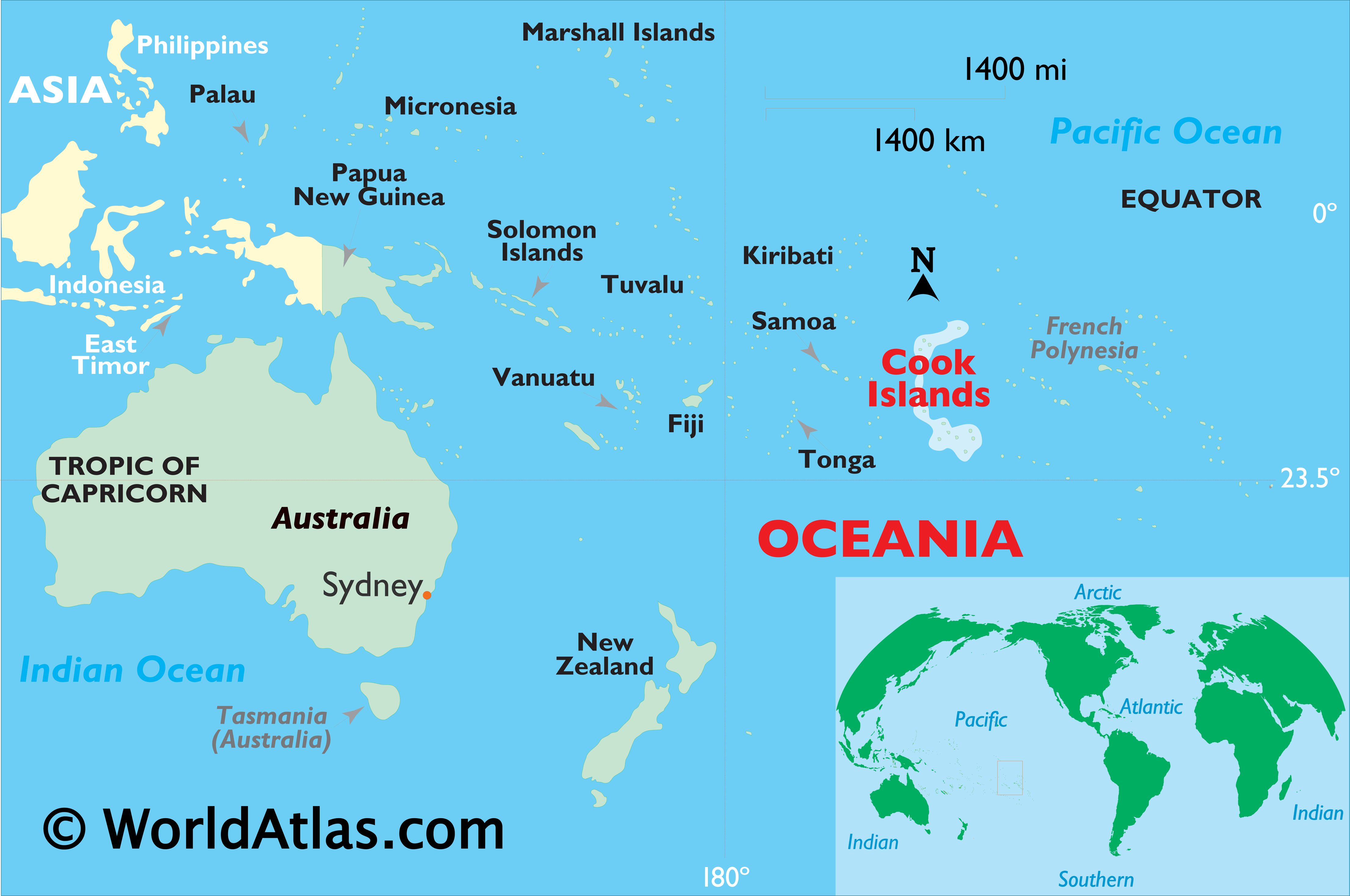
The Cook Islands are in the South Pacific Ocean, north-east of New Zealand, between American Samoa and French Polynesia. There are 15 major islands spread over 2,200,000 km (850,000 sq mi) of ocean, divided into two distinct groups: the Southern Cook Islands and the Northern Cook Islands of coral atolls.
The islands were formed by volcanic activity; the northern group is older and consists of six atolls, which are sunken volcanoes topped by coral growth. The climate is moderate to tropical. The Cook Islands consist of 15 islands and two reefs. From March to December, the Cook Islands are in the path of tropical cyclones, the most notable of which were the cyclones Martin and Percy. Two terrestrial ecoregions lie within the islands’ territory: the Central Polynesian tropical moist forests and the Cook Islands tropical moist forests.
Note: The table is ordered from north to south. Population figures from the 2016 census.