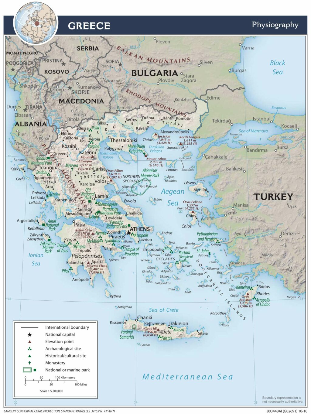
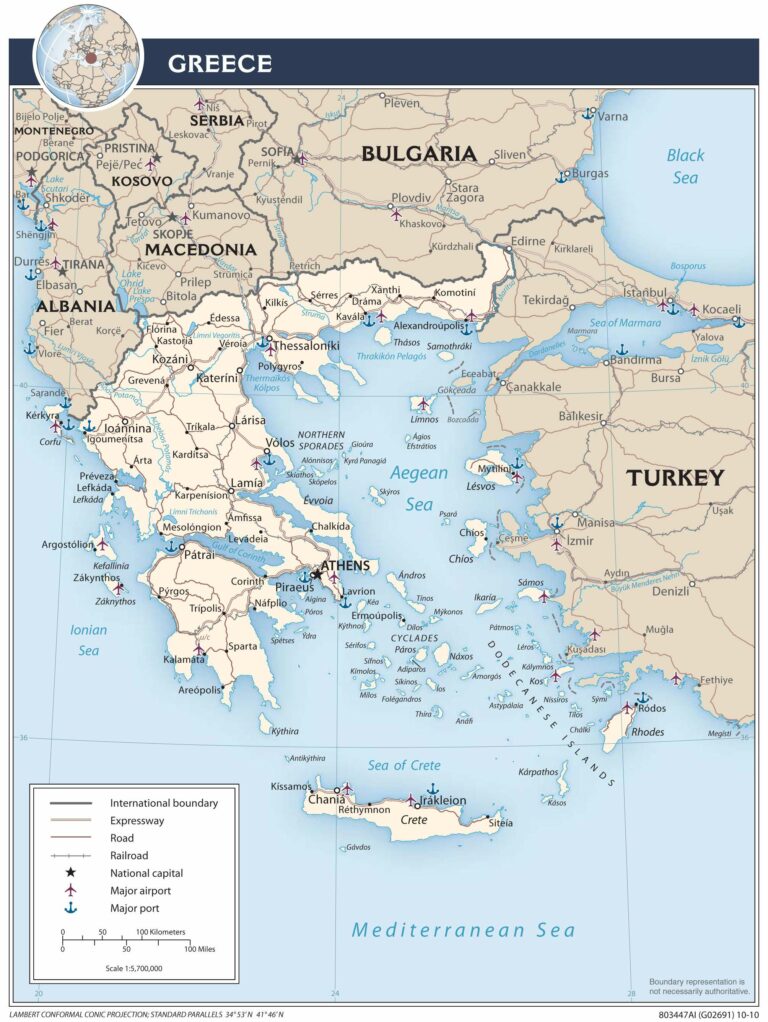
Occupying the southern most part of the Balkan Peninsula, Greece and its many islands (almost 1,500) extend southward from the European continent into the Aegean, Cretan, Ionian, Mediterranean and Thracian seas.
Crete and Evia are its two largest islands and major island groups include the Argo-Saronic, Cyclades, Dodecanese, Ionian, Northeast Aegean and Sporades.
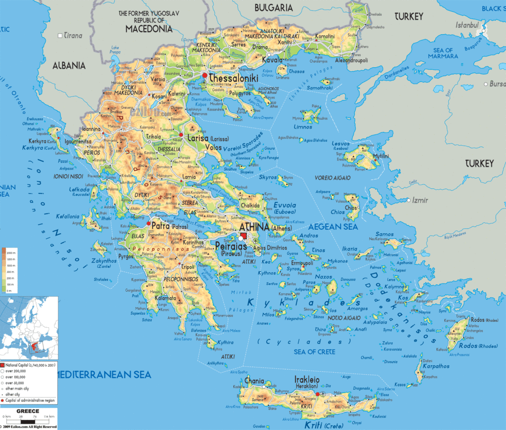
With the vast percentage of its land comprised of hills and rugged mountains, Greece is one of the most mountainous countries in Europe. Its 13,676 km toothy-edged shoreline is deeply indented by dozens of gulfs.
The western half of the country is dominated by the steep peaks of the Pindus mountains, a range of the Dinaric Alps that stretch south from Albania and Macedonia. Typical elevations here exceed 2,500 meters, and those mountains are punctuated by numerous lakes, rivers and wetlands.
The highest Greek mountain is Mount Olympus, rising to 2,918 meters (9,570 ft). To its immediate southwest stand the massive Meteora rock formations; gigantic pillars of stones worn smooth by wind and water over thousands of years.
In the far-north along its border with Bulgaria, the heavily-forested Southern Rhodope Mountain range spreads across the land.
Greece is home to a series of ancient volcanoes, including those on the islands of Kos, Methana, Milos, Nisyros, Poros and Santorini. None are currently erupting, and the last recorded significant eruptions occurred on the island of Nisyros in 1887/1888, and on the island of Santorini in 1950.
The Peloponnese Peninsula is slightly separated from the mainland by the Corinth Canal, a 4-mile long man-made canal through the Isthmus of Corinth. This narrow canal is used primarily for shipping purposes.
While most of the smaller rivers in Greece dry up in the heat of summer, rivers of note include the Acheloos, Aliacmon, Evros and Pinios. Lakes of size include Trichonis, Vegoritis and Volvi.
Explore Greece’s diverse landscape with this interactive map! From its renowned cities to its rugged mountain peaks, its islands to its lakes, rivers, and regions, this map of Greece provides an in-depth look at the country’s topographical features. Satellite imagery and a physical map view of Greece’s national parks and Mount Olympus is also included. Whether you’re planning a trip or simply curious about this beautiful Mediterranean country, this map of Greece will provide you with a comprehensive view of the region.
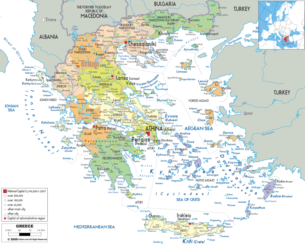
Online Interactive Political Map
Click on ![]() to view map in "full screen" mode.
to view map in "full screen" mode.
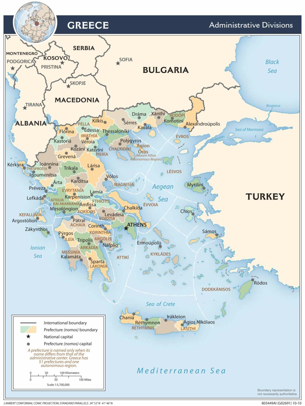
Greece (officially, the Hellenic Republic) is divided into 13 administrative regions (perifereies, singular – perifereia) and 1 autonomous monastic state(aftonomi monastiki politeia). In alphabetical order, the regions are: Anatoliki Makedonia kai Thraki (East Macedonia and Thrace), Attiki (Attica), Dytiki Ellada (West Greece), Dytiki Makedonia (West Macedonia), Ionia Nisia (Ionian Islands), Ipeiros (Epirus), Kentriki Makedonia (Central Macedonia), Kriti (Crete), Notio Aigaio (South Aegean), Peloponnisos (Peloponnese), Sterea Ellada (Central Greece), Thessalia (Thessaly) and Voreio Aigaio (North Aegean). Situated in north eastern Greece, Agion Oros (Mount Athos) is a monastic community and an autonomous region under Greek sovereignty.
Located in the Attica Region, on a peninsula that extends into the Aegean Sea is, Athens – the capital and the largest city in Greece. Athens is one of the oldest continuously inhabited cities in the world. Athens serves as the administrative, cultural, industrial and economic centers of Greece. It is also one of the biggest economic centers in South Eastern Europe. Port Piraeus in Athens is the 2nd largest port in the world and also the largest passenger port in Europe.
Location Maps
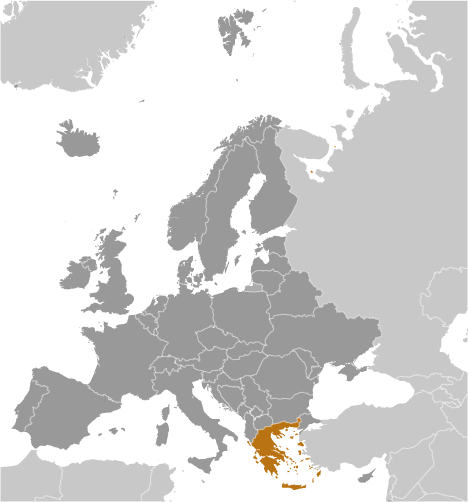
Where is Greece?
Greece is located in southern Europe along the Aegean Sea, Ionian Sea, and Mediterranean Sea. It is categorized as an archipelago because it consists of about 6,000 islands, although only 227 of them are inhabited by human settlements or visited by tourists.
Athens is the capital and largest city of Greece. It borders several European countries, including Albania, North Macedonia, and Bulgaria to the north, as well as Turkey to the northeast.
The country is nicknamed “the cradle of modern Western civilization” due to its lasting influences in the alphabet, libraries, democracy, law, and the Olympics.
High Definition Political Map of Greece

Greece Administrative Map
Physical Map of Greece


