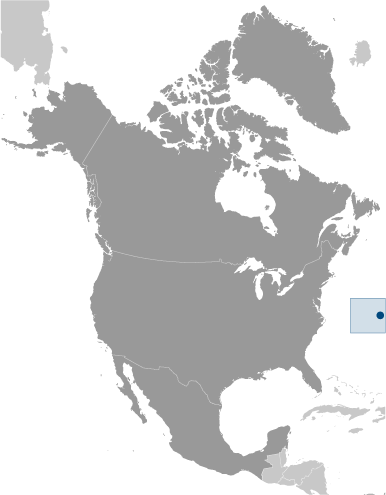
Covering a total area of 53.3 sq. km, the British Overseas Territory of Bermuda (generally referred to as a singular territory) actually consists of 181 islands, of which the Main Island is the largest. Bermuda is located 918 km (570 miles) east-southeast of Cape Hatteras, North Carolina and 1,250km (775 miles) southeast of New York City in the North Atlantic Ocean.
The 8 largest islands are connected by bridges and causeways and form a fishhook-shaped landmass, stretching 22 miles in length and about a mile across. Of all the other small islands, only about a dozen are inhabited. All the islands are volcanic in origin, originating from a mountain mass that rose from the sea floor millions of years ago. The highest point is a hill only 76m (249 ft) high. Its position has been marked by a yellow upright triangle on the physical map of Bermuda seen above.
Also, as observed on the map, the land is generally flat, rising to low hills separated by depressions. The land in these depressions is very fertile and home to most of the agricultural production in Bermuda. The layers of limestone are covered with a red soil, high in iron, low in magnesium. Although there are no freshwater lakes or rivers in Bermuda, the area is lush and green, due to the consistently high levels of rain. Bermuda is one of the most northerly places where coral is found. The reefs, which protect the limestone coastlines from erosion, are protected by law. The reefs are very healthy and are biological hotspots, supporting a diversity of marine law. The important beaches of Bermuda have also been marked on the map.
Experience the beauty of Bermuda with this detailed map showcasing its location in the Atlantic Ocean. This reference map includes settlements, seaports, bays, islands, points, harbors, and its international airport, all of which can be seen in the satellite imagery.
Online Interactive Political Map
Click on ![]() to view map in "full screen" mode.
to view map in "full screen" mode.
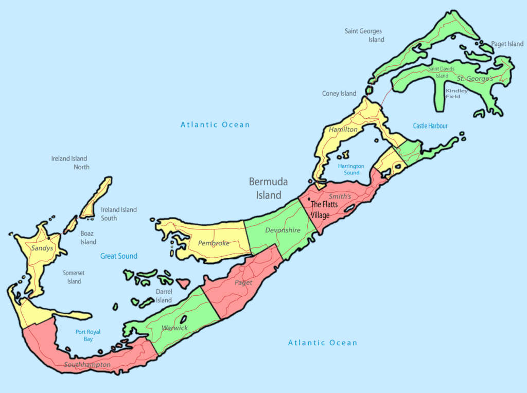
Bermuda is divided into 9 parishes and 2 municipalities. In alphabetical order, the 9 parishes are Devonshire, Hamilton, Paget, Pembroke, Sandys, Smith’s, Southampton, St. George’s and Warwick. The 2 municipalities are: Hamilton and St. George’s.
Covering a total area of 53.3 sq. km, the British Overseas Territory of Bermuda is an archipelago comprising of 181 islands; of which the Main Island is the largest. Located on the northern part of Hamilton Harbour is, Hamilton – the capital city of Bermuda. It is the chief administrative and financial center, an important tourist destination and a major port of the island territory. Situated in the north-eastern part of Bermuda within the St. George’s parish is St. George’s – the largest city of Bermuda.
Location Maps
Where is Bermuda ?
Bermuda is a British Overseas Territory located in the Atlantic Ocean at a distance of approximately 1,035 kilometers (643 mi) from North Carolina in the United States. Comprising seven main islands and 181 islands in total, most of them are uninhabited. With a population of over 65,000 people, it is one of the most populous British territories. Hamilton is the capital and largest city of Bermuda. It is renowned for its pink sandy beaches, coral reefs, and the historic town of St. George.
There is a mysterious history related to the Bermuda Triangle, associated with a number of ships and aircrafts that have disappeared inexplicably. Even today, we are making efforts to uncover the secrets of the Bermuda Triangle Myth with sea dives and understand why those ships and aircrafts never made it to land.
High Definition Political Map of Bermuda

History
Discovery
Bermuda was discovered in the early 1500s by Spanish explorer Juan de Bermúdez. Bermuda had no indigenous population when it was discovered, nor during initial British settlement a century later. It was mentioned in Legatio Babylonica, published in 1511 by historian Pedro Mártir de Anglería, and was included on Spanish charts of that year. Both Spanish and Portuguese ships used the islands as a replenishment spot to take on fresh meat and water. Shipwrecked Portuguese mariners are now thought to have been responsible for the 1543 inscription on Portuguese Rock, previously called Spanish Rock. Legends arose of spirits and devils, now thought to have stemmed from the calls of raucous birds (most likely the Bermuda petrel, or cahow) and loud nocturnal noises from wild hogs. With its frequent storm-racked conditions and dangerous reefs, the archipelago became known as the “Isle of Devils”. Neither Spain nor Portugal attempted to settle it.
Settlement by the English
For the next century, the island was frequently visited but not settled. The English began to focus on the New World, initially settling in Virginia, starting British colonization in North America, establishing a colony at Jamestown, Virginia in 1607. Two years later, a flotilla of seven ships left England with several hundred settlers, food, and supplies to relieve the Jamestown colony. However, the flotilla was broken up by a storm and the flagship, the Sea Venture, drove onto Bermuda’s reef to prevent her sinking, resulting in the survival of all her passengers and crew. The settlers were unwilling to move on, having now heard about the true conditions in Jamestown from the sailors, and made multiple attempts to rebel and stay in Bermuda. They argued that they had a right to stay and establish their own government. The new settlement became a prison labour camp, and built two ships, the Deliverance, and the Patience. Bermuda was now claimed for the English Crown.
In 1612, the English began settlement of the archipelago, officially named Virgineola, with arrival of the ship the Plough. New London (renamed St. George’s Town) was settled that year and designated as the colony’s first capital. It is the oldest continually inhabited English town in the New World.
In 1615, the colony, which had been renamed the Somers Isles in commemoration of Sir George Somers, was passed on to the Somers Isles Company. As Bermudians settled the Carolina Colony and contributed to establishing other English colonies in the Americas, several other locations were named after the archipelago. During this period the first slaves were held and trafficked to the islands. These were a mixture of native Africans who were trafficked to the Americas via the African slave trade and Native Americans who were enslaved from the Thirteen Colonies.
The archipelago’s limited land area and resources led to the creation of what may be the earliest conservation laws of the New World. In 1616 and 1620 acts were passed banning the hunting of certain birds and young tortoises.
Civil War
In 1649, the English Civil War was taking place and King Charles I was beheaded in Whitehall, London. The conflict spilled over into Bermuda, where most of the colonists developed a strong sense of devotion to the Crown. The royalists ousted the Somers Isles Company’s Governor, and elected John Trimingham as their leader (see Governor of Bermuda). Bermuda’s civil war was ended by militias, and dissenters were pushed to settle The Bahamas under William Sayle.
The rebellious royalist colonies of Bermuda, Virginia, Barbados and Antigua, were the subjects of an Act of the Rump Parliament of England. The royalist colonies were also threatened with invasion. The Government of Bermuda eventually reached an agreement with the Parliament of England which retained the status quo in Bermuda.
Later 17th century
In the 17th century, the Somers Isles Company suppressed shipbuilding, as it needed Bermudians to farm in order to generate income from the land. The Virginia colony, however, far surpassed Bermuda in both quality and quantity of tobacco produced. Bermudians began to turn to maritime trades relatively early in the 17th century, but the Somers Isles Company used all its authority to suppress turning away from agriculture. This interference led to islanders demanding, and receiving, revocation of the company’s charter in 1684, and the company was dissolved.
Bermudians rapidly abandoned agriculture for shipbuilding, replanting farmland with the native juniper trees (Juniperus bermudiana, called Bermuda cedar). Establishing effective control over the Turks Islands, Bermudians deforested their landscape to begin the salt trade. It became the world’s largest and remained the cornerstone of Bermuda’s economy for the next century. Bermudians also vigorously pursued whaling, privateering, and the merchant trade.
The American War of Independence
Bermuda’s ambivalence towards the American rebellion changed in September 1774, when the Continental Congress resolved to ban trade with Great Britain, Ireland, and the West Indies after 10 September 1775. Such an embargo would mean the collapse of their inter-colonial commerce, famine and civil unrest. Lacking political channels with Great Britain, the Tucker Family met in May 1775 with eight other parishioners, and resolved to send delegates to the Continental Congress in July, aiming for an exemption from the ban. Henry Tucker noted a clause in the ban which allowed the exchange of American goods for military supplies. The clause was confirmed by Benjamin Franklin when Tucker met with the Pennsylvania Committee of Safety. Independently, others confirmed this business arrangement with Peyton Randolph, the Charlestown Committee of Safety, and George Washington.
Three American boats, operating from Charlestown, Philadelphia and Newport, sailed to Bermuda, and on 14 August 1775, 100 barrels of gunpowder were taken from the Bermudian magazine while Governor George James Bruere slept, and loaded onto these boats. As a consequence, on 2 October the Continental Congress exempted Bermuda from their trade ban, and Bermuda acquired a reputation for disloyalty. Later that year, the British Parliament passed the Prohibitory Act to prohibit trade with the American rebelling colonies, and sent HMS Scorpion to keep watch over the island. The island’s forts were stripped of cannons. Yet, wartime trade of contraband continued along well-established family connections. With 120 boats by 1775, Bermuda continued to trade with St. Eustatius until 1781, and provided salt to North American ports.
In June 1776, HMS Nautilus secured the island, followed by HMS Galatea in September. Yet, the two British captains seemed more intent on capturing prize money, causing a severe food shortage on the island until the departure of Nautilus in October. After France’s entry into the war in 1778, Henry Clinton refortified the island under the command of Major William Sutherland. As a result, 91 French and American ships were captured in the winter of 1778–1779, bringing the population once again to the brink of starvation. Bermudian trade was severely hampered by the combined efforts of the Royal Navy, the British garrison and loyalist privateers, such that famine struck the island in 1779.
Upon the death of George Bruere in 1780, the governorship passed to his son, George Jr., an active loyalist. Under his leadership, smuggling was stopped, and the Bermudian colonial government was populated with like-minded loyalists. Even Henry Tucker abandoned trading with the United States, because of the presence of many privateers.
The Bermuda Gazette, Bermuda’s first newspaper, began publishing in 1784. The editor, Joseph Stockdale, had been given financial incentive to move to Bermuda with his family and establish the newspaper. He also provided other printing services and operated Bermuda’s first local postal service. The Bermuda Gazette was sold by subscription and delivered to subscribers, with Stockdale’s employee also delivering mail for a fee.
19th century
After the American Revolution, the Royal Navy began improving the harbours on the Bermudas. In 1811, work began on the large Royal Naval Dockyard on Ireland Island, which was to serve as the islands’ principal naval base guarding the western Atlantic Ocean shipping lanes. To guard the dockyard, the British Army built the Bermuda Garrison, and heavily fortified the archipelago.
During the War of 1812 between Britain and the United States, the British attacks on Washington, D.C. and the Chesapeake were planned and launched from Bermuda, where the headquarters of the Royal Navy’s North American Station had recently been moved from Halifax, Nova Scotia.
In 1816, James Arnold, the son of Benedict Arnold, fortified Bermuda’s Royal Naval Dockyard against possible US attacks. Today, the National Museum of Bermuda, which incorporates Bermuda’s Maritime Museum, occupies the Keep of the Royal Naval Dockyard.
Due to its proximity to the southeastern US coast, Bermuda was frequently used during the American Civil War as a stopping point base for the Confederate States’ blockade runners on their runs to and from the Southern states, and England, to evade Union naval vessels on blockade patrol. The blockade runners were then able to transport essential war goods from England and deliver valuable cotton back to England. The old Globe Hotel in St. George’s, which was a centre of intrigue for Confederate agents, is preserved as a public museum.
During the Anglo-Boer War (1899–1902), 5,000 Boer prisoners of war were housed on five islands of Bermuda. They were located according to their views of the war. “Bitterenders” (Afrikaans: Bittereinders), who refused to pledge allegiance to the British Crown, were interned on Darrell’s Island and closely guarded. Other islands such as Morgan’s Island held 884 men, including 27 officers; Tucker’s Island held 809 Boer prisoners, Burt’s Island 607, and Port’s Island held 35. Hinson’s Island housed underage prisoners. The camp cemetery is on Long Island.
The New York Times reported an attempted mutiny by Boer prisoners of war en route to Bermuda and that martial law was enacted on Darrell’s Island.
The most famous escapee was the Boer prisoner of war Captain Fritz Joubert Duquesne, who was serving a life sentence for “conspiracy against the British government and on (the charge of) espionage”. On the night of 25 June 1902, Duquesne slipped out of his tent, worked his way over a barbed-wire fence, swam 1.5 miles (2.4 km) past patrol boats and bright spotlights, through storm-swept waters, using the distant Gibbs Hill Lighthouse for navigation until he arrived ashore on the main island. He settled in the U.S. and later became a spy for Germany in both World Wars. In 1942, Col. Duquesne was arrested by the FBI for leading the Duquesne Spy Ring, which to this day remains the largest espionage case in the history of the United States.
20th and 21st centuries
In the early 20th century Bermuda became a popular destination for American, Canadian and British tourists arriving by sea. The US Smoot–Hawley Tariff Act of 1930, which enacted protectionist trade tariffs on goods imported into the US, led to the demise of Bermuda’s once-thriving agricultural export trade to America and encouraged development of tourism as an alternative source of income. The island was one of the centres for illegal alcohol smuggling during the era of Prohibition in the United States (1920–1933).
A rail line was constructed in Bermuda in the 1920s, opening in 1931 as the Bermuda Railway, which was abandoned in 1948. The right of way is now the Bermuda Railway Trail.
In 1930, after several failed attempts, a Stinson Detroiter seaplane flew to Bermuda from New York City: It was the first aeroplane ever to reach the islands. In 1936, Deutsche Luft Hansa began to experiment with seaplane flights from Berlin via the Azores with continuation flights to New York City.
In 1937, Imperial Airways and Pan American Airways began operating scheduled flying boat airline services from New York and Baltimore to Darrell’s Island, Bermuda. In World War II, the Hamilton Princess Hotel became a censorship centre. All mail, radio and telegraphic traffic bound for Europe, the US and the Far East was intercepted and analysed by 1,200 censors, of British Imperial Censorship, part of British Security Coordination (BSC), before being routed to their destination. With BSC working closely with the FBI, the censors were responsible for the discovery and arrest of a number of Axis spies operating in the US, including the Joe K ring.
In 1948, a regularly scheduled commercial airline service began to operate, using land-based aeroplanes landing at Kindley Field (now L.F. Wade International Airport), helping tourism to reach a peak in the 1960s and 1970s. By the end of the 1970s, however, international business had supplanted tourism as the dominant sector of Bermuda’s economy.
The Royal Naval Dockyard and its attendant military garrison remained important to Bermuda’s economy until the mid-20th century. In addition to considerable building work, the armed forces needed to source food and other materials from local vendors. Beginning in World War II, US military installations were also located in Bermuda, including a naval air station, and submarine base. The American military presence lasted until 1995.
Universal adult suffrage and development of a two-party political system took place in the 1960s. Universal suffrage was adopted as part of Bermuda’s Constitution in 1967; voting had previously been dependent on a certain level of property ownership.
On 10 March 1973, the governor of Bermuda, Richard Sharples, was assassinated by local Black Power militants during a period of civil unrest. Some moves were made towards possible independence for the islands, however, this was decisively rejected in a referendum in 1995.
At the 2020 Summer Olympics, Bermuda became the smallest overseas territory to earn a gold medal, as Flora Duffy won Bermuda’s first ever olympic gold medal in the women’s triathlon.
Physical Map of Bermuda


